Fayl:MazandaranDamavand.PNG
Naviqasiyaya keçin
Axtarışa keçin
Sınaq göstərişi ölçüsü: 800 × 293 piksel. Digər ölçülər: 320 × 117 piksel | 931 × 341 piksel.
Faylın orijinalı (931 × 341 piksel, fayl həcmi: 34 KB, MIME növü: image/png)
| Bu fayl "Vikimedia Commons"dadır və digər layihələrdə istifadə edilə bilər. |
 |
Faylın təsvir səhifəsinə get |
| İzah |
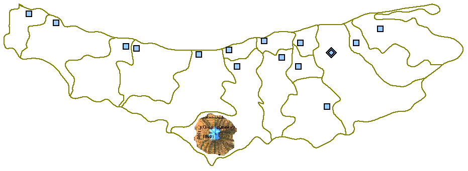
English: Map of Māzandarān Province showing the location of Mount Damāvand in the south of Amol County. |
| Tarix | |
| Mənbə |
This file was derived from: MazandaranPlainMap.PNG |
| Müəllif | Siamax |
| |
This work has been released into the public domain by its author, Siamax, at the ingilis Vikipediya project. This applies worldwide. In case this is not legally possible: |
Orijinal yükləmə gündəliyi
The original description page was here. All following user names refer to en.wikipedia.
- 2006-09-06 14:55 Siamax (Author: http://en.wikipedia.org/wiki/User:Siamax Source: http://en.wikipedia.org/wiki/Image:MazandaranPlainMap.PNG Tag: Damavand location in Mazandaran)
Faylın tarixçəsi
Faylın əvvəlki versiyasını görmək üçün gün/tarix bölməsindəki tarixlərə klikləyin.
| Tarix/Vaxt | Kiçik şəkil | Ölçülər | İstifadəçi | Şərh | |
|---|---|---|---|---|---|
| indiki | 22:52, 27 avqust 2007 | 931 × 341 (34 KB) | Hessam | From en:Image:MazandaranDamavand.PNG {{PD-user-w|en|English Wikipedia|Siamax}} {{Information |Description= Map of Māzandarān province showing the location of mount Damāvand in the south. |Source= http://en.wikipedia.org/wiki/Image:MazandaranPla |
Fayl keçidləri
Aşağıdakı səhifə bu faylı istifadə edir:
Faylın qlobal istifadəsi
Bu fayl aşağıdakı vikilərdə istifadə olunur:
- ar.wikipedia.org layihəsində istifadəsi
- ast.wikipedia.org layihəsində istifadəsi
- ca.wikipedia.org layihəsində istifadəsi
- cs.wikipedia.org layihəsində istifadəsi
- cv.wikipedia.org layihəsində istifadəsi
- en.wikipedia.org layihəsində istifadəsi
- es.wikipedia.org layihəsində istifadəsi
- fa.wikipedia.org layihəsində istifadəsi
- fi.wikipedia.org layihəsində istifadəsi
- kk.wikipedia.org layihəsində istifadəsi
- mzn.wikipedia.org layihəsində istifadəsi
- ru.wikipedia.org layihəsində istifadəsi
- uk.wikipedia.org layihəsində istifadəsi
- uz.wikipedia.org layihəsində istifadəsi
- zh.wikipedia.org layihəsində istifadəsi