Fayl:Aegean Sea by Piri Reis.jpg
Aegean_Sea_by_Piri_Reis.jpg (724 × 562 piksel, fayl həcmi: 304 KB, MIME növü: image/jpeg)
| Bu fayl "Vikimedia Commons"dadır və digər layihələrdə istifadə edilə bilər. |
 |
Faylın təsvir səhifəsinə get |
Xülasə
| İzah |
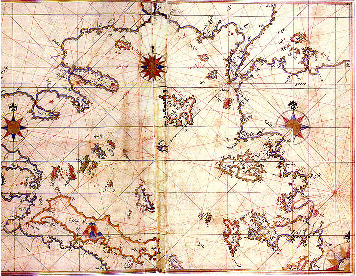
English: Aegean Sea in the Kitab-ı Bahriye (Book of Navigation) of Piri Reis
Map of Rhodes and Marmaris made by Turkish Admiral Piri Reis appearing in his maritime guide-book of 1528, Kitab-i Bahriye. Original is in Nuruosmaniye Library in Istanbul, Türkiyə. |
||||||||||||||||||||
| Tarix | 29 oktyabr 2006 (original upload date) | ||||||||||||||||||||
| Mənbə | Transferred from en.wikipedia to Commons. | ||||||||||||||||||||
| Müəllif |
|
||||||||||||||||||||

Lisenziya
|
This work is in the public domain in its country of origin and other countries and areas where the copyright term is the author's life plus 70 years or fewer.
| |
| This file has been identified as being free of known restrictions under copyright law, including all related and neighboring rights. | |
| Bu təsvirin redaktəsi, orijinala əsaslanaraq rəqəmsal qaydadadır. Dəyişiklik: central vertical part flattened (stretched). Redaktə etdi PawełMM.
|
Orijinal yükləmə gündəliyi
- 2006-10-29 23:03 Shuppiluliuma 795×567× (280442 bytes) [[Aegean Sea]] in the Kitab-ı Bahriye (Book of Navigation) of [[Piri Reis]] {{PD-old}}
Faylın tarixçəsi
Faylın əvvəlki versiyasını görmək üçün gün/tarix bölməsindəki tarixlərə klikləyin.
| Tarix/Vaxt | Kiçik şəkil | Ölçülər | İstifadəçi | Şərh | |
|---|---|---|---|---|---|
| indiki | 16:48, 15 iyun 2010 | | 724 × 562 (304 KB) | PawełMM | vertical center part flattened |
| 09:09, 6 aprel 2008 |  | 795 × 567 (274 KB) | Marsyas | {{Information |Description=Map of Rhodes and Marmaris made by Turkish Admiral Piri Reis appearing in his maritime guide-book of 1528, Kitab-i Bahriye. Original is in Nuruosmaniye Library in Istanbul, Turkey. |Source=[http://upload.wikimedia.org/wikipedia/ |
Fayl keçidləri
Aşağıdakı 2 səhifə bu faylı istifadə edir:
Faylın qlobal istifadəsi
Bu fayl aşağıdakı vikilərdə istifadə olunur:
- ar.wikipedia.org layihəsində istifadəsi
- bn.wikipedia.org layihəsində istifadəsi
- co.wikipedia.org layihəsində istifadəsi
- en.wikipedia.org layihəsində istifadəsi
- Aegean Sea
- Camirus
- Lindus
- Saria Island
- Rineia
- Dracanum
- Ialysus
- Thasos (town)
- Wikipedia:Graphics Lab/Photography workshop/Archive/Jun 2010
- Polium
- Islands (Roman province)
- Oenoe (Icaria)
- Delphinium (Chios)
- Nysa (Naxos)
- Panormus (Skopelos)
- Polichne (Chios)
- Polichne (Naxos)
- Poeeessa
- Apollonia, Sifnos (ancient town)
- Serrheum (Samothrace)
- Arisba (Lesbos)
- Nape (Lesbos)
- Aegeirus
- Pyrrha (Lesbos)
- Hiera (Lesbos)
- Metaon
- Geren (Lesbos)
- Issa (Lesbos)
- Xanthus (Lesbos)
- Penthile
- Therma (Lesbos)
- Malea (Lesbos)
- Sigron
- Messon (Lesbos)
- Agamede (Lesbos)
- Chryse (Lesbos)
- Hyperdexion
- Minoa (Amorgos)
- Aegiale (Amorgos)
- Arcesine
- Melania (Amorgos)
- Coressia
- Lepsia
- Phora (Greece)
- Corsiae
- Therma (Icaria)
- Histoi
Bu faylın qlobal istifadəsinə baxın.