Fayl:Aerial-View-Minamitori-Island-1987.jpg
Naviqasiyaya keçin
Axtarışa keçin

Sınaq göstərişi ölçüsü: 800 × 507 piksel. Digər ölçülər: 320 × 203 piksel | 640 × 405 piksel | 1.024 × 649 piksel | 1.280 × 811 piksel | 2.824 × 1.789 piksel.
Faylın orijinalı (2.824 × 1.789 piksel, fayl həcmi: 1,09 MB, MIME növü: image/jpeg)
| Bu fayl "Vikimedia Commons"dadır və digər layihələrdə istifadə edilə bilər. |
 |
Faylın təsvir səhifəsinə get |
Xülasə
| İzah |
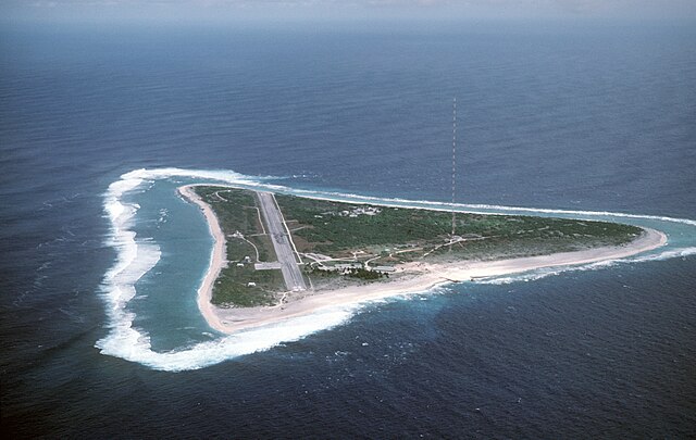
English: Aerial view of Minamitori Island (Minami-Torishima), Japan. There is a runway which supported the US Coast Guard station located there prior to 1993. Minamitori Island is the easternmost island of the Japanese archipelago.
Deutsch: Luftaufnahme der Minamitori Insel (Minami-Torishima), Japan.
日本語: 南鳥島の空中写真。 |
|||
| Tarix | ||||
| Mənbə |
|
|||
| Müəllif | Chief Master Sergeant Don Sutherland, U.S. Air Force |
Lisenziya
This image is a work of a U.S. military or Department of Defense employee, taken or made as part of that person's official duties. As a work of the U.S. federal government, the image is in the public domain in the United States.
|
 |
Faylın tarixçəsi
Faylın əvvəlki versiyasını görmək üçün gün/tarix bölməsindəki tarixlərə klikləyin.
| Tarix/Vaxt | Kiçik şəkil | Ölçülər | İstifadəçi | Şərh | |
|---|---|---|---|---|---|
| indiki | 01:38, 18 yanvar 2007 | | 2.824 × 1.789 (1,09 MB) | Balcer~commonswiki | ID: DFST8708298 Service Depicted: Coalition or Allied Forces Aerial view of Marcus Island and the runway which supports the US Coast Guard station located there. Marcus Island is the southernmost island in the Japanese chain. Camera Operator: CMSGT |
Fayl keçidləri
Aşağıdakı səhifə bu faylı istifadə edir:
Faylın qlobal istifadəsi
Bu fayl aşağıdakı vikilərdə istifadə olunur:
- ar.wikipedia.org layihəsində istifadəsi
- ast.wikipedia.org layihəsində istifadəsi
- be.wikipedia.org layihəsində istifadəsi
- ca.wikipedia.org layihəsində istifadəsi
- ceb.wikipedia.org layihəsində istifadəsi
- cs.wikipedia.org layihəsində istifadəsi
- de.wikipedia.org layihəsində istifadəsi
- el.wikipedia.org layihəsində istifadəsi
- en.wikipedia.org layihəsində istifadəsi
- es.wikipedia.org layihəsində istifadəsi
- et.wikipedia.org layihəsində istifadəsi
- eu.wikipedia.org layihəsində istifadəsi
- fa.wikipedia.org layihəsində istifadəsi
- fi.wikipedia.org layihəsində istifadəsi
- frr.wikipedia.org layihəsində istifadəsi
- fr.wikipedia.org layihəsində istifadəsi
- fr.wiktionary.org layihəsində istifadəsi
- gl.wikipedia.org layihəsində istifadəsi
- hy.wikipedia.org layihəsində istifadəsi
- it.wikipedia.org layihəsində istifadəsi
- ja.wikipedia.org layihəsində istifadəsi
- ja.wikibooks.org layihəsində istifadəsi
Bu faylın qlobal istifadəsinə baxın.