Fayl:Andorra topographic map-ca.svg

Faylın orijinalı (SVG faylı, nominal olaraq 1.625 × 1.300 piksel, faylın ölçüsü: 1,58 MB)
| Bu fayl "Vikimedia Commons"dadır və digər layihələrdə istifadə edilə bilər. |
 |
Faylın təsvir səhifəsinə get |
| Camera location | | View this and other nearby images on: OpenStreetMap |
|---|
| İzah |
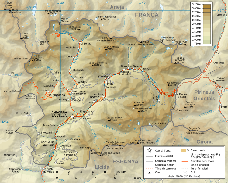
Català: Mapa topogràfic d'Andorra en versió en català English: Topographic map in Catalan of Andorra Français : Carte topographique en catalan de l'Andorre |
| Tarix | (UTC) |
| Mənbə |
Català: Traducció de Andorra_topographic_map-fr.svg
L'original té les dades topogràfiques de la Missió NASA Shuttle Radar Topography (SRTM3 v.2) (domini públic) editat amb 3DEM i dlgv32 Pro i vectoritzat amb l'Inkscape; projecció UTM; WGS84 datum; relleu ombrejat (imatge composta de posicions lluminoses de NO, O i N). Referència per les dades addicionals:
Escala aproximada de les dades topogràfiques: 1:400.000 (precisió: uns 100 m); Nota: El relleu ombrejat és una imatge rastrejada immersa en el fitxer SVG. English: Translation from Andorra_topographic_map-fr.svg
Topographic data from the NASA Shuttle Radar Topography Mission (SRTM3 v.2) (public domain) edited with 3DEM and dlgv32 Pro and vectorized with Inkscape; UTM projection; WGS84 datum; shaded relief (composite image of N-W, W and N lightning positions); Reference used for the additional data:
Approximate scale of topographic data: 1:400,000 (accuracy: about 100 m); Note : The shaded relief is a raster image embedded in the SVG file. Français : Traduction d'Andorra_topographic_map-fr.svg
Données topographiques de la NASA Shuttle Radar Topography Mission (SRTM3 v.2) (domaine public) éditées avec 3DEM et dlgv32 Pro et vectorisées avec Inkscape ; projection UTM ; WGS84 datum ; relief ombré (image composite d'éclairages du N-O, O et N) ; Références utilisées pour les données complémentaires :
Échelle approximative des données topographiques : 1:400 000 (précision : environ 100 m) ; Note : Le relief ombré est une image bitmap embarquée dans le fichier SVG. Approximate geographic limits of the map (3" close):
|
| Müəllif |
|
| Digər versiyalar |
[]
|


|
Bu sənədi GNU Azad Sənədləşdirmə Lisenziyası, Versiya 1.2 və ya Azad Proqram Fondu tərəfindən nəşr olunan hər hansı sonrakı versiya şərtlərinə əsasən dəyişməz bölmələr, ön qapaq mətnləri və arxa qapaq mətnləri olmadan köçürmək, yayımlamaq və / və ya dəyişdirmək üçün icazə verilir; Lisenziyanın bir nüsxəsi GNU Azad Sənədləşdirmə Lisenziyası adlı hissəyə daxil edilmişdir. |
- Azadsınız:
- paylaşmaq – əsəri köçürmək, paylamaq və ötürmək üçün
- remiks etmək – əsəri adaptasiya etmək
- Aşağıdakı şərtlərə riayət etməklə:
- istinad – Müvafiq kredit verməlisiniz, lisenziyaya bir keçid verməlisiniz və dəyişikliklərin olub olmadığını bildirməlisiniz. Bunu hər hansı bir ağlabatan şəkildə edə bilərsiniz, ancaq lisenziyalaşdırıcının sizi və ya istifadənizi təsdiqləməsini təklif edən bir şəkildə deyil.
- bənzər paylaşma – Əsəri remix edirsinizsə, dəyişdirirsinizsə və ya üzərində iş aparırsınızsa, öz töhfələrinizi orijinalda olduğu kimi eyni və ya uyğun lisenziya altında yayımlamalısınız.

|
This SVG file contains embedded text that can be translated into your language, using any capable SVG editor, text editor or the SVG Translate tool. For more information see: About translating SVG files. |
Orijinal yükləmə gündəliyi
This image is a derivative work of the following images:
- Image:Andorra_topographic_map-fr.svg licensed with Cc-by-sa-3.0,2.5,2.0,1.0
- 2008-06-12T20:03:47Z Sting 1625x1300 (1654623 Bytes) Correction on a name.
- 2008-03-07T14:37:41Z Sting 1625x1300 (1654334 Bytes) Improved shaded relief and other details
- 2008-02-28T04:26:38Z Sting 1625x1300 (1275242 Bytes) {{Location|42|33|00|N|01|36|00|E|scale:200000}} {{Information |Description={{en|Topographic map in French of [[:Category:Andorra|Andorra]]}}{{fr|Carte topographique en français de l'[[:Category:Andorra|Andorre]]}} |Source={
Uploaded with derivativeFX
Faylın tarixçəsi
Faylın əvvəlki versiyasını görmək üçün gün/tarix bölməsindəki tarixlərə klikləyin.
| Tarix/Vaxt | Kiçik şəkil | Ölçülər | İstifadəçi | Şərh | |
|---|---|---|---|---|---|
| indiki | 19:00, 26 oktyabr 2010 | | 1.625 × 1.300 (1,58 MB) | SMP | topònim actualitzats amb el nomenclàtor d'Andorra de 2010 |
| 11:46, 2 sentyabr 2008 |  | 1.625 × 1.300 (1,58 MB) | SMP | {{Information |Description= |Source= |Date= |Author= |Permission= |other_versions= }} | |
| 15:30, 1 sentyabr 2008 |  | 1.625 × 1.300 (1,36 MB) | SMP | {{Information |Description={{ca|Mapa topogràfic d'Andorra en versió en català}}{{en|Topographic map in Catalan of Andorra}}{{fr|Carte topographique en catalan de l'Andorre}} |Source=*[[:Image:Andorra_topographic_map- |
Fayl keçidləri
Aşağıdakı səhifə bu faylı istifadə edir:
Faylın qlobal istifadəsi
Bu fayl aşağıdakı vikilərdə istifadə olunur:
- an.wikipedia.org layihəsində istifadəsi
- ca.wikipedia.org layihəsində istifadəsi
- co.wikipedia.org layihəsində istifadəsi
- en.wikipedia.org layihəsində istifadəsi
- es.wikipedia.org layihəsində istifadəsi
- fi.wikipedia.org layihəsində istifadəsi
- fr.wikinews.org layihəsində istifadəsi
- id.wikipedia.org layihəsində istifadəsi
- ja.wikipedia.org layihəsində istifadəsi
- oc.wikipedia.org layihəsində istifadəsi
- pt.wikipedia.org layihəsində istifadəsi
- simple.wikipedia.org layihəsində istifadəsi
- sl.wikipedia.org layihəsində istifadəsi
- vi.wikipedia.org layihəsində istifadəsi
- www.wikidata.org layihəsində istifadəsi