Fayl:Austria-Hungary map with legend ES.svg
Naviqasiyaya keçin
Axtarışa keçin

Bu SVG-faylın PNG formatındakı bu görünüşünün ölçüsü: 776 × 600 piksel. Digər ölçülər: 311 × 240 piksel | 621 × 480 piksel | 994 × 768 piksel | 1.280 × 989 piksel | 2.560 × 1.978 piksel | 783 × 605 piksel.
Faylın orijinalı (SVG faylı, nominal olaraq 783 × 605 piksel, faylın ölçüsü: 344 KB)
| Bu fayl "Vikimedia Commons"dadır və digər layihələrdə istifadə edilə bilər. |
 |
Faylın təsvir səhifəsinə get |
| İzah |
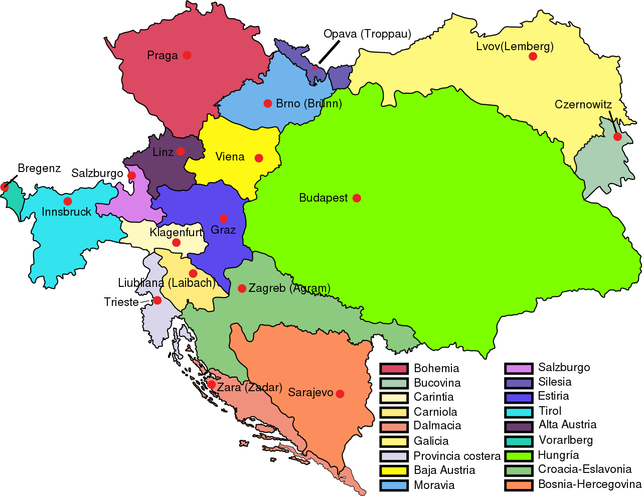
English:
Austria–Hungary: Empire of Austria (Cisleithania): 1. Bohemia, 2. Bukovina, 3. Carinthia, 4. Carniola, 5. Dalmatia, 6. Galicia, 7. Küstenland, 8. Lower Austria, 9. Moravia, 10. Salzburg, 11. Silesia, 12. Styria, 13. Tyrol, 14. Upper Austria, 15. Vorarlberg; Kingdom of Hungary (Transleithania): 16. Hungary proper 17. Croatia-Slavonia; Austrian-Hungarian Co-dominion: 18. Bosnia and Herzegovina Deutsch:
Österreich-Ungarn 1910: Cisleithanien: 1. Böhmen, 2. Bukowina, 3. Kärnten, 4. Krain, 5. Dalmatien, 6. Galizien, 7. Küstenland, 8. Österreich unter der Enns, 9. Mähren, 10. Salzburg, 11. Schlesien, 12. Steiermark, 13. Tirol, 14. Österreich ob der Enns, 15. Vorarlberg; Transleithanien: 16. Ungarn, 17. Kroatien und Slawonien; 18. Bosnien und Herzegowina Español: Austria–Hungría: Imperio Austriaco (Cisleitania): 1. Bohemia, 2. Bucovina, 3. Carintia, 4. Carniola, 5. Dalmacia, 6. Galicia, 7. Provincia costera 8. Baja Austria, 9. Moravia, 10. Salzburgo, 11. Silesia, 12. Estiria, 13. Tirol, 14. Alta Austria, 15. Vorarlberg; Reino de Hungría (Transleitania): 16. Hungría 17. Croacia-Eslavonia; Condomio austro-magiar: 18. Bosnia y Hercegovina |
| Tarix | (UTC) |
| Mənbə | |
| Müəllif |
|
| Bu təsvirin redaktəsi, orijinala əsaslanaraq rəqəmsal qaydadadır. Dəyişiklik: Spanish version in svg. New legend and colours.. İlkin təsvir buradadır: Austria-Hungary map new.svg. Redaktə etdi Rowanwindwhistler.
|
I, the copyright holder of this work, hereby publish it under the following license:
| |
This work has been released into the public domain by its author, Example, at the [[::|ingilis Vikipediya]] project. This applies worldwide. In case this is not legally possible: |
Orijinal yükləmə gündəliyi
This image is a derivative work of the following images:
- File:Austria-Hungary_map_new.svg licensed with PD-user-w
- 2009-02-20T12:28:19Z Ivh123 783x605 (250731 Bytes) {{Information |Description={{en| '''Austria–Hungary''':'''Empire of Austria (Cisleithania)''': 1. Bohemia, 2. Bukovina, 3. Carinthia, 4. Carniola, 5. Dalmatia, 6. Galicia, 7. Küstenland, 8. Lower Austria, 9. Moravia, 10. S
Uploaded with derivativeFX
Faylın tarixçəsi
Faylın əvvəlki versiyasını görmək üçün gün/tarix bölməsindəki tarixlərə klikləyin.
| Tarix/Vaxt | Kiçik şəkil | Ölçülər | İstifadəçi | Şərh | |
|---|---|---|---|---|---|
| indiki | 17:31, 11 fevral 2010 | | 783 × 605 (344 KB) | Rowanwindwhistler | {{Information |Description={{en| <br>'''<u>Austria–Hungary</u>''':<br>'''Empire of Austria (Cisleithania)''': 1. Bohemia, 2. Bukovina, 3. Carinthia, 4. Carniola, 5. Dalmatia, 6. Galicia, 7. Küstenland, 8. Lower Austria, 9. Moravia, 10. Salzburg, 11. Si |
Fayl keçidləri
Aşağıdakı səhifə bu faylı istifadə edir:
Faylın qlobal istifadəsi
Bu fayl aşağıdakı vikilərdə istifadə olunur:
- es.wikipedia.org layihəsində istifadəsi