Fayl:Band-e-Amir National Park, Afghanistan.jpg
Naviqasiyaya keçin
Axtarışa keçin

Sınaq göstərişi ölçüsü: 600 × 600 piksel. Digər ölçülər: 240 × 240 piksel | 480 × 480 piksel | 768 × 768 piksel | 1.024 × 1.024 piksel | 2.048 × 2.048 piksel | 3.500 × 3.500 piksel.
Faylın orijinalı (3.500 × 3.500 piksel, fayl həcmi: 4,14 MB, MIME növü: image/jpeg)
| Bu fayl "Vikimedia Commons"dadır və digər layihələrdə istifadə edilə bilər. |
 |
Faylın təsvir səhifəsinə get |
Xülasə
| İzah |
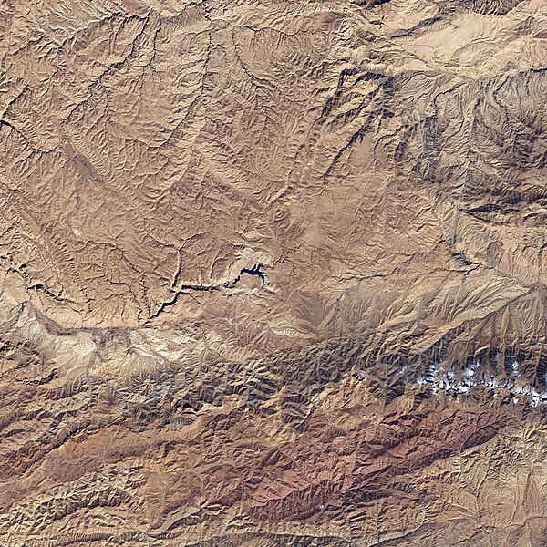
English: The starkness of the landscape highlights the ruggedness of the terrain around the lakes in this satellite image of Band-e-Amir National Park. Towering cliffs create sharp lines and shadows on the south (bottom) side of many of the lakes. The lakes range in color from faint turquoise to deep blue. |
| Tarix | |
| Mənbə | NASA Earth Observatory |
| Müəllif | NASA image created by Jesse Allen, using Landsat data provided by the United States Geological Survey. |
Landsat 7 - ETM+
Lisenziya
| This file is in the public domain in the United States because it was solely created by NASA. NASA copyright policy states that "NASA material is not protected by copyright unless noted". (See Template:PD-USGov, NASA copyright policy page or JPL Image Use Policy.) | ||
 |
Warnings:
|
Faylın tarixçəsi
Faylın əvvəlki versiyasını görmək üçün gün/tarix bölməsindəki tarixlərə klikləyin.
| Tarix/Vaxt | Kiçik şəkil | Ölçülər | İstifadəçi | Şərh | |
|---|---|---|---|---|---|
| indiki | 14:42, 26 aprel 2009 | | 3.500 × 3.500 (4,14 MB) | Originalwana | {{Information |Description={{en|1=The starkness of the landscape highlights the ruggedness of the terrain around the lakes in this satellite image of Band-e-Amir National Park. Towering cliffs create sharp lines and shadows on the south side of many of th |
Fayl keçidləri
Aşağıdakı səhifə bu faylı istifadə edir:
Faylın qlobal istifadəsi
Bu fayl aşağıdakı vikilərdə istifadə olunur:
- bg.wikipedia.org layihəsində istifadəsi
- en.wikipedia.org layihəsində istifadəsi
- fi.wikipedia.org layihəsində istifadəsi
- id.wikipedia.org layihəsində istifadəsi
- no.wikipedia.org layihəsində istifadəsi
- pa.wikipedia.org layihəsində istifadəsi
- ru.wikipedia.org layihəsində istifadəsi
- sat.wikipedia.org layihəsində istifadəsi
- sv.wikipedia.org layihəsində istifadəsi
- uk.wikipedia.org layihəsində istifadəsi