Fayl:Caledonides EN.svg
Naviqasiyaya keçin
Axtarışa keçin

Bu SVG-faylın PNG formatındakı bu görünüşünün ölçüsü: 630 × 421 piksel. Digər ölçülər: 320 × 214 piksel | 640 × 428 piksel | 1.024 × 684 piksel | 1.280 × 855 piksel | 2.560 × 1.711 piksel.
Faylın orijinalı (SVG faylı, nominal olaraq 630 × 421 piksel, faylın ölçüsü: 126 KB)
| Bu fayl "Vikimedia Commons"dadır və digər layihələrdə istifadə edilə bilər. |
 |
Faylın təsvir səhifəsinə get |
Xülasə
| İzah |
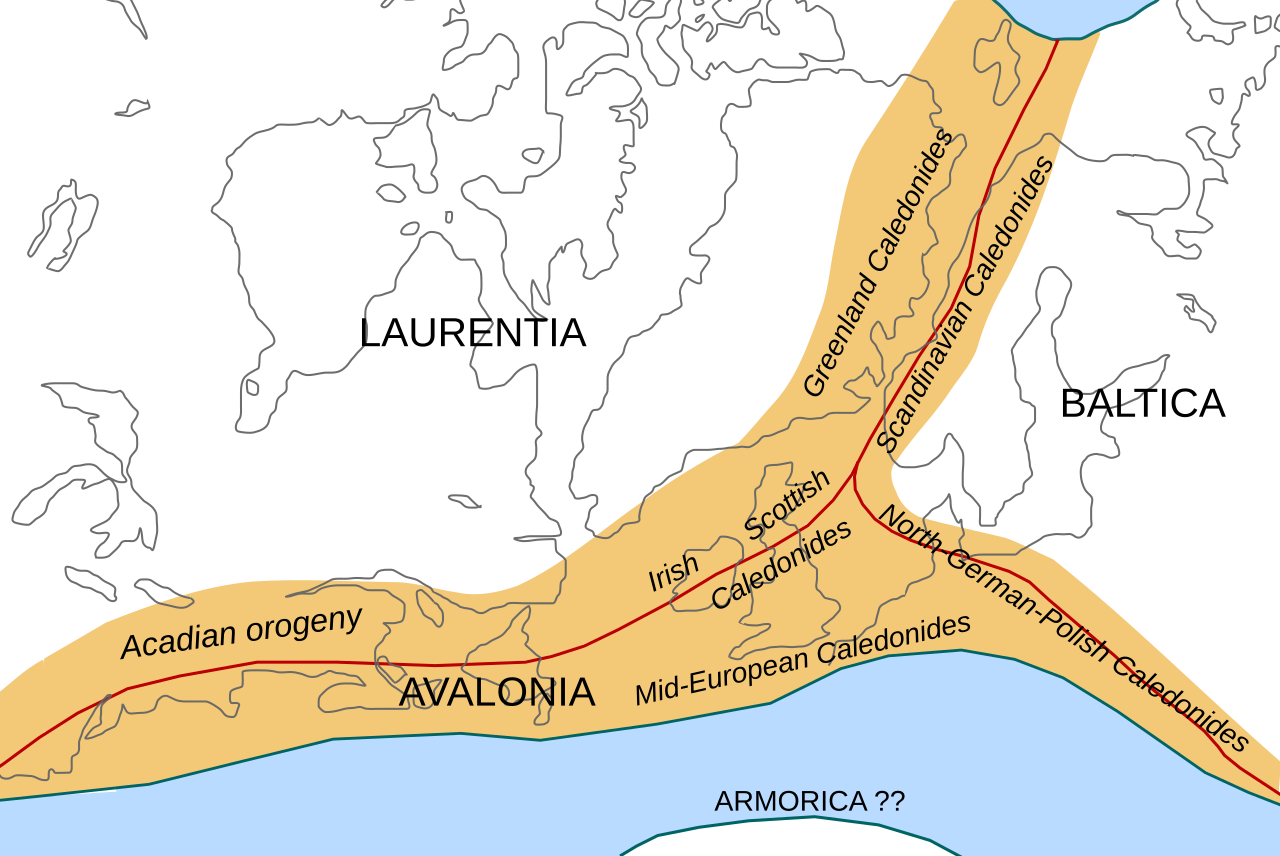
English: Location of the Caledonian/Acadian mountain chains in the Early Devonian Epoch. Present day coastlines are shown for reference. Red lines are sutures, capitalized names are the different continents/super-terranes that joined during the Caledonian orogeny. See en:Avalonia, en:Baltica, en:Laurentia.
Literature used to make this map:
|
| Tarix | |
| Mənbə | Öz işi |
| Müəllif | Woudloper |
| Digər versiyalar |
Derivative works of this file: |

|
This SVG file contains embedded text that can be translated into your language, using any capable SVG editor, text editor or the SVG Translate tool. For more information see: About translating SVG files. |
W3C-validity not checked.
Lisenziya
This file is licensed under the Creative Commons Attribution-Share Alike 1.0 Generic license.
- Azadsınız:
- paylaşmaq – əsəri köçürmək, paylamaq və ötürmək üçün
- remiks etmək – əsəri adaptasiya etmək
- Aşağıdakı şərtlərə riayət etməklə:
- istinad – Müvafiq kredit verməlisiniz, lisenziyaya bir keçid verməlisiniz və dəyişikliklərin olub olmadığını bildirməlisiniz. Bunu hər hansı bir ağlabatan şəkildə edə bilərsiniz, ancaq lisenziyalaşdırıcının sizi və ya istifadənizi təsdiqləməsini təklif edən bir şəkildə deyil.
- bənzər paylaşma – If you alter, transform, or build upon this work, you must distribute the resulting work under the same license as the original.
Faylın tarixçəsi
Faylın əvvəlki versiyasını görmək üçün gün/tarix bölməsindəki tarixlərə klikləyin.
| Tarix/Vaxt | Kiçik şəkil | Ölçülər | İstifadəçi | Şərh | |
|---|---|---|---|---|---|
| indiki | 10:45, 28 oktyabr 2008 | | 630 × 421 (126 KB) | Woudloper | == Beschreibung == {{Information |Description={{en|1=Location of the Caledonian/Acadian mountain chains in the Early Devonian Epoch. Present day coastlines are shown for reference. Red lines are sutures, capitalized names are the different continents/supe |
| 09:50, 23 oktyabr 2008 |  | 630 × 421 (132 KB) | Woudloper | == Beschreibung == {{Information |Description={{en|1=Location of the Caledonian/Acadian mountain chains in the Early Devonian Epoch. Present day coastlines are shown for reference. Red lines are sutures, capitalized names are the different continents/supe | |
| 15:17, 21 oktyabr 2008 |  | 630 × 421 (132 KB) | Woudloper | {{Information |Description={{en|1=Location of the Caledonian/Acadian mountain chains in the Early Devonian Epoch. Present day coastlines are shown for reference. Red lines are sutures, capitalized names are the different continents/super-terranes that joi |
Fayl keçidləri
Aşağıdakı səhifə bu faylı istifadə edir:
Faylın qlobal istifadəsi
Bu fayl aşağıdakı vikilərdə istifadə olunur:
- be-tarask.wikipedia.org layihəsində istifadəsi
- be.wikipedia.org layihəsində istifadəsi
- bg.wikipedia.org layihəsində istifadəsi
- ca.wikipedia.org layihəsində istifadəsi
- da.wikipedia.org layihəsində istifadəsi
- en.wikipedia.org layihəsində istifadəsi
- fa.wikipedia.org layihəsində istifadəsi
- fr.wikipedia.org layihəsində istifadəsi
- gl.wikipedia.org layihəsində istifadəsi
- hy.wikipedia.org layihəsində istifadəsi
- id.wikipedia.org layihəsində istifadəsi
- it.wikipedia.org layihəsində istifadəsi
- ja.wikipedia.org layihəsində istifadəsi
- lv.wikipedia.org layihəsində istifadəsi
- mk.wikipedia.org layihəsində istifadəsi
- nl.wikipedia.org layihəsində istifadəsi
- nn.wikipedia.org layihəsində istifadəsi
- no.wikipedia.org layihəsində istifadəsi
- pl.wikipedia.org layihəsində istifadəsi
- ro.wikipedia.org layihəsində istifadəsi
- ru.wikipedia.org layihəsində istifadəsi
- simple.wikipedia.org layihəsində istifadəsi
- sl.wikipedia.org layihəsində istifadəsi
- tr.wikipedia.org layihəsində istifadəsi
- uk.wikipedia.org layihəsində istifadəsi
- vi.wikipedia.org layihəsində istifadəsi
- zh.wikipedia.org layihəsində istifadəsi