Fayl:Climate maps of Iran (Köppen-Geiger).png
Naviqasiyaya keçin
Axtarışa keçin

Sınaq göstərişi ölçüsü: 672 × 600 piksel. Digər ölçülər: 269 × 240 piksel | 538 × 480 piksel | 861 × 768 piksel | 1.147 × 1.024 piksel | 2.000 × 1.785 piksel.
Faylın orijinalı (2.000 × 1.785 piksel, fayl həcmi: 312 KB, MIME növü: image/png)
| Bu fayl "Vikimedia Commons"dadır və digər layihələrdə istifadə edilə bilər. |
.png?uselang=az) |
Faylın təsvir səhifəsinə get |
.png)
Xülasə
| İzah |
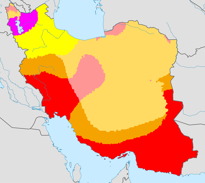
English: Climate map of Iran, using the Köppen-Geiger climate classification |
| Tarix | (UTC) |
| Mənbə |
This file was derived from: |
| Müəllif |
|
Lisenziya
Bu fayl Creative Commons Attribution-Share Alike 3.0 Unported lisenziyası altında yayımlanır.
- Azadsınız:
- paylaşmaq – əsəri köçürmək, paylamaq və ötürmək üçün
- remiks etmək – əsəri adaptasiya etmək
- Aşağıdakı şərtlərə riayət etməklə:
- istinad – Müvafiq kredit verməlisiniz, lisenziyaya bir keçid verməlisiniz və dəyişikliklərin olub olmadığını bildirməlisiniz. Bunu hər hansı bir ağlabatan şəkildə edə bilərsiniz, ancaq lisenziyalaşdırıcının sizi və ya istifadənizi təsdiqləməsini təklif edən bir şəkildə deyil.
- bənzər paylaşma – Əsəri remix edirsinizsə, dəyişdirirsinizsə və ya üzərində iş aparırsınızsa, öz töhfələrinizi orijinalda olduğu kimi eyni və ya uyğun lisenziya altında yayımlamalısınız.
Orijinal yükləmə gündəliyi
This image is a derivative work of the following images:
- File:World Köppen Map.png licensed with Cc-by-sa-3.0
- 2011-03-13T12:13:30Z Maphobbyist 4231x2804 (1168443 Bytes) Painted the Caspian Sea as white as it should have been, because the Köppen system is based on the concept that climate types are correlated with the natural vegetation. Thus with Köppen, climate zone boundaries have been s
- 2010-03-05T23:41:54Z Aiyizo 4231x2804 (344162 Bytes) Cropped white space, compressed with pngout. I've also converted the image to indexed mode with an optimal 64 color palette. This introduces minor alaising effects to the region edges, but it gives a massive reduction in fi
- 2007-10-12T22:35:59Z Jeroen 4250x2815 (2188412 Bytes)
- 2007-10-12T22:05:31Z Jeroen 6708x4443 (3366169 Bytes) Citation: '''Peel, M. C., Finlayson, B. L., and McMahon, T. A.: Updated world map of the Köppen-Geiger climate classification, Hydrol. Earth Syst. Sci., 11, 1633-1644, 2007.''' {{Information |Description= Updated world map
- File:Iran_location_map.svg licensed with Cc-by-sa-3.0, GFDL
- 2013-04-15T17:55:21Z NordNordWest 1200x1071 (306314 Bytes) according to http://images.persianblog.ir/516041_B0b76ypr.jpg + Tabas -> South Khorasan province
- 2013-04-12T17:40:10Z Yamaha5 1200x1071 (655114 Bytes) Reverted to version as of 20:08, 11 July 2010
- 2013-04-12T17:38:55Z Yamaha5 1200x1071 (655114 Bytes) Reverted to version as of 20:08, 11 July 2010 in all maps khorasan is like past!
- 2013-03-17T11:30:56Z NordNordWest 1200x1071 (301415 Bytes) upd
- 2010-07-11T20:08:23Z Uwe Dedering 1200x1071 (655114 Bytes) 31. province Alborz
- 2010-02-18T17:44:29Z Uwe Dedering 1200x1071 (721726 Bytes) Bahrain above water, no disputed countries
- 2010-02-18T13:00:48Z Uwe Dedering 1200x1071 (725716 Bytes) {{Information |Description={{en|1=Location map of Iran. Equirectangular projection. Strechted by 118.0%. Geographic limits of the map: * N: 40.0° N * S: 24.5° N * W: 43.5° E * E: 64.0° E Made with Natural Earth. Fre
Uploaded with derivativeFX
Faylın tarixçəsi
Faylın əvvəlki versiyasını görmək üçün gün/tarix bölməsindəki tarixlərə klikləyin.
| Tarix/Vaxt | Kiçik şəkil | Ölçülər | İstifadəçi | Şərh | |
|---|---|---|---|---|---|
| indiki | 20:39, 21 iyun 2013 | | 2.000 × 1.785 (312 KB) | Underlying lk | == {{int:filedesc}} == {{Information |Description={{en|1=Climate map of Iran, using the Köppen-Geiger climate classification}} |Source={{Derived from|World_Koppen_Map.png|Iran_location_map.svg|display=50}} |Date=2013-06-21 20:36 (UTC) |Author=*[[:File... |
Fayl keçidləri
Aşağıdakı səhifə bu faylı istifadə edir:
Faylın qlobal istifadəsi
Bu fayl aşağıdakı vikilərdə istifadə olunur:
- nn.wikipedia.org layihəsində istifadəsi
- te.wikipedia.org layihəsində istifadəsi
.png)