Fayl:Dipsacus fullonum MHNT.BOT.2005.0.269.jpg
Naviqasiyaya keçin
Axtarışa keçin

Sınaq göstərişi ölçüsü: 701 × 599 piksel. Digər ölçülər: 281 × 240 piksel | 562 × 480 piksel | 898 × 768 piksel | 1.198 × 1.024 piksel | 2.396 × 2.048 piksel | 4.432 × 3.789 piksel.
Faylın orijinalı (4.432 × 3.789 piksel, fayl həcmi: 6,01 MB, MIME növü: image/jpeg)
| Bu fayl "Vikimedia Commons"dadır və digər layihələrdə istifadə edilə bilər. |
 |
Faylın təsvir səhifəsinə get |
|
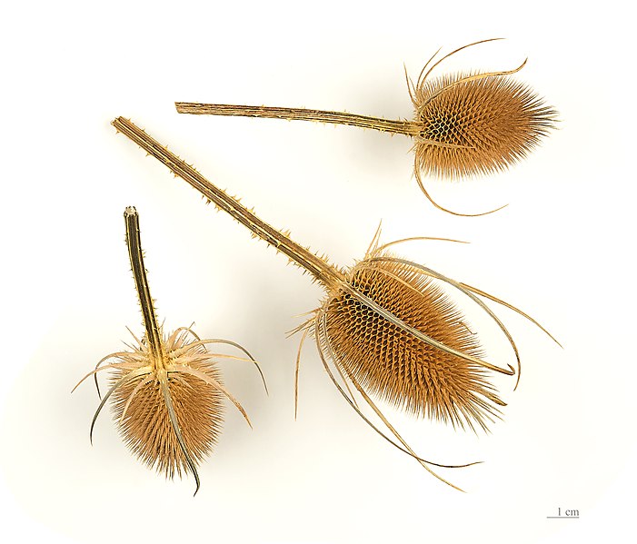
Dipsacus fullonum L., 1753 |
| Fotoqraf | ||||||||||||||||||||||||
| İzah |
Deutsch: Früchte am Ende der Laufzeit, von Wilde Karde English: Fruit at maturity, of Fuller's teasel. Français : Fruit à maturité de La Cardère sauvage. |
|||||||||||||||||||||||
| location of discovery | ||||||||||||||||||||||||
| Tarix | Taken on 24 avqust 2012 | |||||||||||||||||||||||
| Collection |
|
|||||||||||||||||||||||
| Accession number |
MHNT.BOT.2005.0.969 |
|||||||||||||||||||||||
| Mənbə | Öz işi | |||||||||||||||||||||||
| İcazə (Faylın təkrar istifadəsi) |
I, the copyright holder of this work, hereby publish it under the following license: This file is licensed under the Creative Commons Attribution-Share Alike 4.0 International license.
|
|||||||||||||||||||||||

| Camera location | | View this and other nearby images on: OpenStreetMap |
|---|

|
This document was made as part of the Projet Phoebus.
|
Assessment
|

Faylın tarixçəsi
Faylın əvvəlki versiyasını görmək üçün gün/tarix bölməsindəki tarixlərə klikləyin.
| Tarix/Vaxt | Kiçik şəkil | Ölçülər | İstifadəçi | Şərh | |
|---|---|---|---|---|---|
| indiki | 05:48, 24 avqust 2012 | | 4.432 × 3.789 (6,01 MB) | Archaeodontosaurus | {{Information |Description ={{en|1=x}} |Source ={{own}} |Author =Archaeodontosaurus |Date = |Permission = |other_versions = }} |
Fayl keçidləri
Bu faylı istifadə edən səhifə yoxdur.
Faylın qlobal istifadəsi
Bu fayl aşağıdakı vikilərdə istifadə olunur:
- ast.wikipedia.org layihəsində istifadəsi
- ca.wikipedia.org layihəsində istifadəsi
- de.wikipedia.org layihəsində istifadəsi
- el.wikipedia.org layihəsində istifadəsi
- en.wikipedia.org layihəsində istifadəsi
- en.wiktionary.org layihəsində istifadəsi
- es.wikipedia.org layihəsində istifadəsi
- es.wiktionary.org layihəsində istifadəsi
- eu.wikipedia.org layihəsində istifadəsi
- fr.wikipedia.org layihəsində istifadəsi
- fr.wiktionary.org layihəsində istifadəsi
- hsb.wikipedia.org layihəsində istifadəsi
- it.wikipedia.org layihəsində istifadəsi
- li.wikipedia.org layihəsində istifadəsi
- ml.wikipedia.org layihəsində istifadəsi
- nl.wikipedia.org layihəsində istifadəsi
- pt.wikipedia.org layihəsində istifadəsi
- ru.wikipedia.org layihəsində istifadəsi
- simple.wikipedia.org layihəsində istifadəsi
- sv.wikipedia.org layihəsində istifadəsi
- vi.wikipedia.org layihəsində istifadəsi