Fayl:France 1939.png
Naviqasiyaya keçin
Axtarışa keçin

Sınaq göstərişi ölçüsü: 800 × 351 piksel. Digər ölçülər: 320 × 140 piksel | 640 × 281 piksel | 1.425 × 625 piksel.
Faylın orijinalı (1.425 × 625 piksel, fayl həcmi: 33 KB, MIME növü: image/png)
| Bu fayl "Vikimedia Commons"dadır və digər layihələrdə istifadə edilə bilər. |
 |
Faylın təsvir səhifəsinə get |
[This Map is badly colorized : Indochina (Annam, Tonkin, Cambodia, Laos), Pacific Islands, African countries, etc. are quite invisible.]

|
File:France 1939.svg is a vector version of this file. It should be used in place of this PNG file when not inferior.
File:France 1939.png → File:France 1939.svg
For more information, see Help:SVG. |
 |
Xülasə
| İzah |
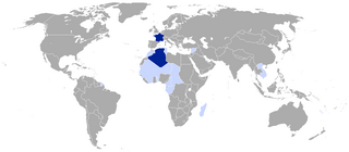
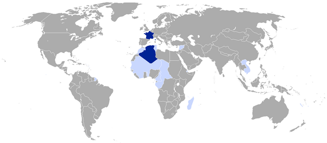
This map depicts the territorial situation of France subsequent to the 1939 en:Invasion of Poland.
|
||
| Tarix | |||
| Mənbə |
|
||
| Müəllif | VoodooIsland | ||
| İcazə (Faylın təkrar istifadəsi) |
|
Orijinal yükləmə gündəliyi
The original description page was here. All following user names refer to en.wikipedia.
Upload date | User | Bytes | Dimensions | Comment
- 2011-09-09 00:38:29 | SpencerCS | 33545 | 1425×625 | Added French India
- 2010-04-29 10:55:54 | VoodooIsland | 58986 | 1425×625 | self-made
Faylın tarixçəsi
Faylın əvvəlki versiyasını görmək üçün gün/tarix bölməsindəki tarixlərə klikləyin.
| Tarix/Vaxt | Kiçik şəkil | Ölçülər | İstifadəçi | Şərh | |
|---|---|---|---|---|---|
| indiki | 15:45, 4 iyul 2023 | | 1.425 × 625 (33 KB) | Huic2856 | Revert; Algeria was made an integral part of Metropolitan France in 1848. |
| 12:56, 8 may 2017 |  | 1.425 × 625 (33 KB) | Taketa | Reverted to version as of 06:03, 19 June 2016 (UTC) | |
| 12:52, 8 may 2017 |  | 1.425 × 625 (33 KB) | Taketa | Revert, see talk page | |
| 06:03, 19 iyun 2016 |  | 1.425 × 625 (33 KB) | Houmouvazine | Corrected Algeria to colonial departments status, per source | |
| 15:09, 30 noyabr 2011 |  | 1.425 × 625 (33 KB) | OwenBlacker | {{BotMoveToCommons|en.wikipedia|year={{subst:CURRENTYEAR}}|month={{subst:CURRENTMONTHNAME}}|day={{subst:CURRENTDAY}}}} The upload bot is User:CommonsHelper2 Bot which is called by [http://toolserver.org/~commonshelper2/index.php CommonsHelper2]. The t |
Fayl keçidləri
Bu faylı istifadə edən səhifə yoxdur.
Faylın qlobal istifadəsi
Bu fayl aşağıdakı vikilərdə istifadə olunur:
- en.wikipedia.org layihəsində istifadəsi
- fr.wikipedia.org layihəsində istifadəsi