Fayl:Geologic map of Crater Lake floor.png
Naviqasiyaya keçin
Axtarışa keçin
Daha yüksək versiyası yoxdur.
Geologic_map_of_Crater_Lake_floor.png (477 × 544 piksel, fayl həcmi: 12 KB, MIME növü: image/png)
| Bu fayl "Vikimedia Commons"dadır və digər layihələrdə istifadə edilə bilər. |
 |
Faylın təsvir səhifəsinə get |
| İzah |
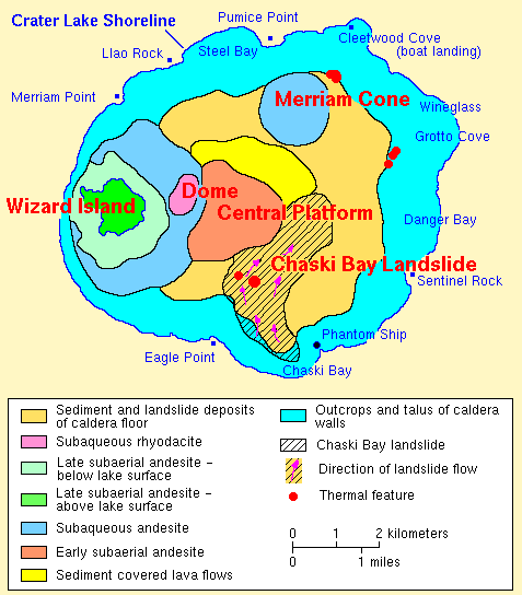
English: USGS |
| Mənbə | http://vulcan.wr.usgs.gov/Volcanoes/CraterLake/Maps/map_geology_crater_lake_floor.html |
| Müəllif | United States Geological Survey |

|
This geology image could be re-created using vector graphics as an SVG file. This has several advantages; see Commons:Media for cleanup for more information. If an SVG form of this image is available, please upload it and afterwards replace this template with
{{vector version available|new image name}}.
It is recommended to name the SVG file “Geologic map of Crater Lake floor.svg”—then the template Vector version available (or Vva) does not need the new image name parameter. |
Lisenziya
This image is in the public domain in the United States because it only contains materials that originally came from the United States Geological Survey, an agency of the United States Department of the Interior. For more information, see the official USGS copyright policy.
|
Orijinal yükləmə gündəliyi
The original description page was here. All following user names refer to en.wikipedia.
- 2007-10-31 07:09 Peteforsyth 477×544× (12660 bytes) crop out extraneous text
- 2004-05-18 06:08 Mav 500×750× (23601 bytes) [[USGS]] photo from [http://vulcan.wr.usgs.gov/Volcanoes/CraterLake/Maps/map_geology_crater_lake_floor.html] <br><br>{{msg:PD}}
Faylın tarixçəsi
Faylın əvvəlki versiyasını görmək üçün gün/tarix bölməsindəki tarixlərə klikləyin.
| Tarix/Vaxt | Kiçik şəkil | Ölçülər | İstifadəçi | Şərh | |
|---|---|---|---|---|---|
| indiki | 20:50, 9 aprel 2009 | | 477 × 544 (12 KB) | File Upload Bot (Magnus Manske) | {{BotMoveToCommons|en.wikipedia|year={{subst:CURRENTYEAR}}|month={{subst:CURRENTMONTHNAME}}|day={{subst:CURRENTDAY}}}} {{Information |Description={{en|en:USGS photo from [http://vulcan.wr.usgs.gov/Volcanoes/CraterLake/Maps/map_geology_crater_lake_f |
Fayl keçidləri
Bu faylı istifadə edən səhifə yoxdur.
Faylın qlobal istifadəsi
Bu fayl aşağıdakı vikilərdə istifadə olunur:
- en.wikipedia.org layihəsində istifadəsi
- fr.wikipedia.org layihəsində istifadəsi
- he.wikipedia.org layihəsində istifadəsi
- it.wikipedia.org layihəsində istifadəsi
- ja.wikipedia.org layihəsində istifadəsi
- simple.wikipedia.org layihəsində istifadəsi