Fayl:Germany occupation zones with border.jpg
Naviqasiyaya keçin
Axtarışa keçin

Sınaq göstərişi ölçüsü: 722 × 599 piksel. Digər ölçülər: 289 × 240 piksel | 578 × 480 piksel | 925 × 768 piksel | 1.234 × 1.024 piksel | 1.460 × 1.212 piksel.
Faylın orijinalı (1.460 × 1.212 piksel, fayl həcmi: 861 KB, MIME növü: image/jpeg)
| Bu fayl "Vikimedia Commons"dadır və digər layihələrdə istifadə edilə bilər. |
 |
Faylın təsvir səhifəsinə get |

|
This map image could be re-created using vector graphics as an SVG file. This has several advantages; see Commons:Media for cleanup for more information. If an SVG form of this image is available, please upload it and afterwards replace this template with
{{vector version available|new image name}}.
It is recommended to name the SVG file “Germany occupation zones with border.svg”—then the template Vector version available (or Vva) does not need the new image name parameter. |


Xülasə
| İzah |
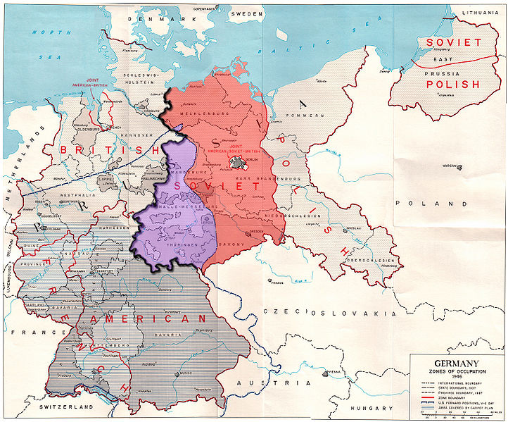
English: Map of the occupation zones of Germany in 1945, modified to show the inner German border and the zone from which Allied forces withdrew in July 1945. From Earl F. Ziemke, The U.S. Army in the Occupation of Germany, 1975. Library of Congress, Catalog Card Number 75-619027.
Deutsch: Karte der Besatzungszonen in Deutschland im Jahr 1945. Sie wurde modifiziert, um die innerdeutsche Grenze und die Zone, aus der sich die Alliierten im Juli 1945 zurückzogen, zu verdeutlichen. Von Earl F. Ziemke, Die US-Armee während der Besetzung Deutschlands, 1975. Kongress-Bibliothek, Katalog-Karten-Nummer 75-619027.
Français : Carte des zones d'occupation de l'Allemagne en 1945, modifié pour montrer la frontière allemande intérieure et la zone d'où les forces alliées se retirèrent en Juillet 1945. De Earl F. Ziemke, l'armée américaine dans l'occupation de l'Allemagne, 1975. Bibliothèque du Congrès, Catalogue Numéro de la carte 75-619027.
Русский: Карта, показывающая зоны оккупации послевоенной Германии, а также линию продвижения американских войск на день капитуляции. Юго-западная часть советской зоны оккупации, около трети её общей площади, находилась западней американских позиций на день капитуляции. Советская зона выделена красным, а область, из которой были отведены в июле 1945 года британские и американские войска — фиолетовым, внутригерманская граница показана жирной чёрной линией. Границы областей показаны в соответствии с территориальным делением Веймарской республики, до современного федерального деления на земли. |
||
| Tarix | |||
| Mənbə | Modified version of http://www.globalsecurity.org/military/library/report/other/us-army_germany_1944-46_map3.htm | ||
| Müəllif | US Army | ||
| Digər versiyalar |
|
Lisenziya
This file is a work of a U.S. Army soldier or employee, taken or made as part of that person's official duties. As a work of the U.S. federal government, it is in the public domain in the United States.
|
 |
Faylın tarixçəsi
Faylın əvvəlki versiyasını görmək üçün gün/tarix bölməsindəki tarixlərə klikləyin.
| Tarix/Vaxt | Kiçik şəkil | Ölçülər | İstifadəçi | Şərh | |
|---|---|---|---|---|---|
| indiki | 23:52, 24 sentyabr 2009 | | 1.460 × 1.212 (861 KB) | ChrisO | Fixed errors |
| 16:57, 19 sentyabr 2009 |  | 1.460 × 1.212 (863 KB) | ChrisO | {{Information |Description={{en|1=Map of the occupation zones of Germany in 1945, modified to show the inner German border and the zone from which Allied forces withdrew in July 1945. From Earl F. Ziemke, ''The U.S. Army in the Occupation of Germany'', 19 |
Fayl keçidləri
Aşağıdakı səhifə bu faylı istifadə edir:
Faylın qlobal istifadəsi
Bu fayl aşağıdakı vikilərdə istifadə olunur:
- ar.wikipedia.org layihəsində istifadəsi
- ast.wikipedia.org layihəsində istifadəsi
- azb.wikipedia.org layihəsində istifadəsi
- cs.wikipedia.org layihəsində istifadəsi
- da.wikipedia.org layihəsində istifadəsi
- de.wikipedia.org layihəsində istifadəsi
- el.wikipedia.org layihəsində istifadəsi
- en.wikipedia.org layihəsində istifadəsi
- es.wikipedia.org layihəsində istifadəsi
- fa.wikipedia.org layihəsində istifadəsi
- fr.wikipedia.org layihəsində istifadəsi
- he.wikipedia.org layihəsində istifadəsi
- hr.wikipedia.org layihəsində istifadəsi
- id.wikipedia.org layihəsində istifadəsi
- it.wikipedia.org layihəsində istifadəsi
- ka.wikipedia.org layihəsində istifadəsi
- ko.wikipedia.org layihəsində istifadəsi
- ml.wikipedia.org layihəsində istifadəsi
- my.wikipedia.org layihəsində istifadəsi
- pl.wikipedia.org layihəsində istifadəsi
- pnb.wikipedia.org layihəsində istifadəsi
- pt.wikipedia.org layihəsində istifadəsi
- ru.wikipedia.org layihəsində istifadəsi
- sv.wikipedia.org layihəsində istifadəsi
- ta.wikipedia.org layihəsində istifadəsi
- te.wikipedia.org layihəsində istifadəsi
Bu faylın qlobal istifadəsinə baxın.