Fayl:GulfofMaine.jpg
Naviqasiyaya keçin
Axtarışa keçin
Daha yüksək versiyası yoxdur.
GulfofMaine.jpg (523 × 544 piksel, fayl həcmi: 285 KB, MIME növü: image/jpeg)
| Bu fayl "Vikimedia Commons"dadır və digər layihələrdə istifadə edilə bilər. |
 |
Faylın təsvir səhifəsinə get |
Origin
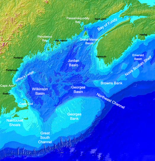
Found on the english Wikipedia Image :GulfofMaine.jpg. Digital bathymetry map of the Gulf of Maine. Credit: National Oceanographic and Atmospheric Administration and U.S. Geological Survey (USGS) Woods Hole, MA Labels by Syagria.)
Xülasə
Digital bathymetry map of the Gulf of Maine. Credit: National Oceanographic and Atmospheric Administration and U.S. Geological Survey (USGS) Woods Hole, MA. Labels by Syagria.
Lisenziya
This image is in the public domain because it contains materials that originally came from the U.S. National Oceanic and Atmospheric Administration, taken or made as part of an employee's official duties.
|
Faylın tarixçəsi
Faylın əvvəlki versiyasını görmək üçün gün/tarix bölməsindəki tarixlərə klikləyin.
| Tarix/Vaxt | Kiçik şəkil | Ölçülər | İstifadəçi | Şərh | |
|---|---|---|---|---|---|
| indiki | 00:32, 27 noyabr 2006 | | 523 × 544 (285 KB) | TCY | ==Origin== Found on the english Wikipedia [http://en.wikipedia.org/wiki/Image:GulfofMaine.jpg Image :GulfofMaine.jpg] == Summary == Digital bathymetry map of the Gulf of Maine. Credit: National Oceanographic and Atmospheric Administration and U.S. Geolog |
Fayl keçidləri
Aşağıdakı səhifə bu faylı istifadə edir:
Faylın qlobal istifadəsi
Bu fayl aşağıdakı vikilərdə istifadə olunur:
- be.wikipedia.org layihəsində istifadəsi
- bg.wikipedia.org layihəsində istifadəsi
- ca.wikipedia.org layihəsində istifadəsi
- ce.wikipedia.org layihəsində istifadəsi
- da.wikipedia.org layihəsində istifadəsi
- en.wikipedia.org layihəsində istifadəsi
- en.wikiversity.org layihəsində istifadəsi
- es.wikipedia.org layihəsində istifadəsi
- eu.wikipedia.org layihəsində istifadəsi
- fa.wikipedia.org layihəsində istifadəsi
- fi.wikipedia.org layihəsində istifadəsi
- fr.wikipedia.org layihəsində istifadəsi
- gl.wikipedia.org layihəsində istifadəsi
- hr.wikipedia.org layihəsində istifadəsi
- id.wikipedia.org layihəsində istifadəsi
- is.wikipedia.org layihəsində istifadəsi
- ka.wikipedia.org layihəsində istifadəsi
- ko.wikipedia.org layihəsində istifadəsi
- lt.wikipedia.org layihəsində istifadəsi
- ml.wikipedia.org layihəsində istifadəsi
- pt.wikipedia.org layihəsində istifadəsi
- ru.wikipedia.org layihəsində istifadəsi
- ta.wikipedia.org layihəsində istifadəsi
- zh.wikipedia.org layihəsində istifadəsi