Fayl:Kosovo map-en.svg
Naviqasiyaya keçin
Axtarışa keçin

Bu SVG-faylın PNG formatındakı bu görünüşünün ölçüsü: 582 × 599 piksel. Digər ölçülər: 233 × 240 piksel | 466 × 480 piksel | 746 × 768 piksel | 994 × 1.024 piksel | 1.989 × 2.048 piksel | 1.777 × 1.830 piksel.
Faylın orijinalı (SVG faylı, nominal olaraq 1.777 × 1.830 piksel, faylın ölçüsü: 3,81 MB)
| Bu fayl "Vikimedia Commons"dadır və digər layihələrdə istifadə edilə bilər. |
 |
Faylın təsvir səhifəsinə get |
Xülasə
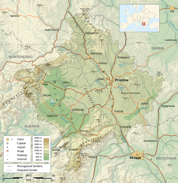
| Description |
Čeština: Mapa Kosova. Dansk: Kort over Kosovo. Deutsch: Karte des Kosovo. English: Map of the Kosovo. Español: Mapa de Kosovo. Français : Carte du Kosovo, en anglais. Italiano: Mappa del Kosovo. Magyar: Koszovó térképe albán és szerb helységnevekkel. Polski: Mapa Kosowa. Română: Harta provinciei Kosovo Svenska: Karta över Kosovo, engelskspråkig. Türkçe: Kosova haritası. Македонски: Карта на Косово на англиски. Русский: Карта Косово, на английском. Українська: Карта Косово 日本語: コソボの地図。 |
||||||
| Tarix | |||||||
| Mənbə |
Own work. Sources :
Software used :
Other data :
|
||||||
| Yaradıcı | |||||||
| Georeferencing | If inappropriate please set warp_status = skip to hide. | ||||||
| Digər versiyalar |
[] | ||||||
| İstinad (required by the license) | © Sémhur / Wikimedia Commons / | ||||||
| Assessments |
|
||||||
| SVG | W3C-validity not checked.
|
||||||
| Graphic Lab |


| Camera location | | View this and other nearby images on: OpenStreetMap |
|---|
Lisenziya
I, the copyright holder of this work, hereby publish it under the following licenses:
| Copyleft: This work of art is free; you can redistribute it and/or modify it according to terms of the Free Art License. You will find a specimen of this license on the Copyleft Attitude site as well as on other sites. |
This file is licensed under the Creative Commons Attribution-Share Alike 4.0 International, 3.0 Unported, 2.5 Generic, 2.0 Generic and 1.0 Generic license.
- Azadsınız:
- paylaşmaq – əsəri köçürmək, paylamaq və ötürmək üçün
- remiks etmək – əsəri adaptasiya etmək
- Aşağıdakı şərtlərə riayət etməklə:
- istinad – Müvafiq kredit verməlisiniz, lisenziyaya bir keçid verməlisiniz və dəyişikliklərin olub olmadığını bildirməlisiniz. Bunu hər hansı bir ağlabatan şəkildə edə bilərsiniz, ancaq lisenziyalaşdırıcının sizi və ya istifadənizi təsdiqləməsini təklif edən bir şəkildə deyil.
- bənzər paylaşma – Əsəri remix edirsinizsə, dəyişdirirsinizsə və ya üzərində iş aparırsınızsa, öz töhfələrinizi orijinalda olduğu kimi eyni və ya uyğun lisenziya altında yayımlamalısınız.
İstədiyiniz lisenziyanı seçə bilərsiniz.
Faylın tarixçəsi
Faylın əvvəlki versiyasını görmək üçün gün/tarix bölməsindəki tarixlərə klikləyin.
| Tarix/Vaxt | Kiçik şəkil | Ölçülər | İstifadəçi | Şərh | |
|---|---|---|---|---|---|
| indiki | 14:35, 21 sentyabr 2023 | | 1.777 × 1.830 (3,81 MB) | Socialdilema | File uploaded using svgtranslate tool (https://svgtranslate.toolforge.org/). Added translation for ca. |
| 18:41, 12 may 2021 |  | 1.777 × 1.830 (3,74 MB) | Uniacademic | Same as the previous edit. | |
| 18:28, 12 may 2021 |  | 1.777 × 1.830 (3,74 MB) | Uniacademic | Updated the names of cities in cases where WP:COMMONNAME has changed since 2008. | |
| 09:14, 5 mart 2008 |  | 1.777 × 1.830 (3,75 MB) | Sémhur | Added borders, with keys (recognized - disputed) | |
| 09:16, 4 mart 2008 |  | 1.777 × 1.830 (3,74 MB) | Sémhur | Remove Kosovo boundaries to neutralize the map, + labels more readable | |
| 14:45, 3 mart 2008 |  | 1.777 × 1.830 (3,74 MB) | Sémhur | Correcting few labels | |
| 19:15, 28 fevral 2008 |  | 1.777 × 1.830 (3,74 MB) | Sémhur | minor changes | |
| 11:37, 26 fevral 2008 |  | 1.777 × 1.830 (3,74 MB) | Sémhur | == Description == {{Information |Description= {{en| Map of the Kosovo.}} {{fr| Carte du Kosovo, en anglais.}} |Source=Own work. {{clr}} Sources : * Topographic background : [http://www2.jpl.nasa.gov/srtm NASA Shuttle Radar To |
Fayl keçidləri
Aşağıdakı səhifə bu faylı istifadə edir:
Faylın qlobal istifadəsi
Bu fayl aşağıdakı vikilərdə istifadə olunur:
- af.wikipedia.org layihəsində istifadəsi
- ar.wikipedia.org layihəsində istifadəsi
- bcl.wikipedia.org layihəsində istifadəsi
- be-tarask.wikipedia.org layihəsində istifadəsi
- bg.wikipedia.org layihəsində istifadəsi
- de.wikipedia.org layihəsində istifadəsi
- de.wikibooks.org layihəsində istifadəsi
- en.wikipedia.org layihəsində istifadəsi
- es.wikipedia.org layihəsində istifadəsi
- fa.wikipedia.org layihəsində istifadəsi
- fi.wikipedia.org layihəsində istifadəsi
- fr.wikipedia.org layihəsində istifadəsi
- fr.wikinews.org layihəsində istifadəsi
- ga.wikipedia.org layihəsində istifadəsi
- gl.wikipedia.org layihəsində istifadəsi
- gv.wikipedia.org layihəsində istifadəsi
- hy.wikipedia.org layihəsində istifadəsi
- is.wikipedia.org layihəsində istifadəsi
- ko.wikipedia.org layihəsində istifadəsi
- lt.wikipedia.org layihəsində istifadəsi
- mg.wikipedia.org layihəsində istifadəsi
- ml.wikipedia.org layihəsində istifadəsi
- mr.wikipedia.org layihəsində istifadəsi
- mzn.wikipedia.org layihəsində istifadəsi
- nn.wikipedia.org layihəsində istifadəsi
- no.wikipedia.org layihəsində istifadəsi
- pa.wikipedia.org layihəsində istifadəsi
Bu faylın qlobal istifadəsinə baxın.