Fayl:Map mexico volcanoes.gif
Naviqasiyaya keçin
Axtarışa keçin
Daha yüksək versiyası yoxdur.
Map_mexico_volcanoes.gif (715 × 368 piksel, fayl həcmi: 14 KB, MIME növü: image/gif)
| Bu fayl "Vikimedia Commons"dadır və digər layihələrdə istifadə edilə bilər. |
 |
Faylın təsvir səhifəsinə get |

|
This map image could be re-created using vector graphics as an SVG file. This has several advantages; see Commons:Media for cleanup for more information. If an SVG form of this image is available, please upload it and afterwards replace this template with
{{vector version available|new image name}}.
It is recommended to name the SVG file “Map mexico volcanoes.svg”—then the template Vector version available (or Vva) does not need the new image name parameter. |
| İzah |
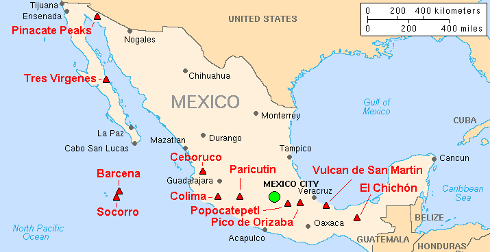
English: Map of major volcanoes of Mexico |
|||
| Tarix | ||||
| Mənbə | Archived source link; base map from CIA, 2003; volcanoes from Simkin and Siebert, 1994 | |||
| Müəllif | Lyn Topinka, USGS | |||
| İcazə (Faylın təkrar istifadəsi) |
|
|||
| Digər versiyalar |
|
Faylın tarixçəsi
Faylın əvvəlki versiyasını görmək üçün gün/tarix bölməsindəki tarixlərə klikləyin.
| Tarix/Vaxt | Kiçik şəkil | Ölçülər | İstifadəçi | Şərh | |
|---|---|---|---|---|---|
| indiki | 08:00, 16 fevral 2014 | | 715 × 368 (14 KB) | Hike395 | Crop title, logo, and credit line |
| 10:58, 19 yanvar 2005 |  | 728 × 465 (18 KB) | GarciaB~commonswiki | Major Volcanoes of Mexico |
Fayl keçidləri
Aşağıdakı səhifə bu faylı istifadə edir:
Faylın qlobal istifadəsi
Bu fayl aşağıdakı vikilərdə istifadə olunur:
- ar.wikipedia.org layihəsində istifadəsi
- bg.wikipedia.org layihəsində istifadəsi
- bs.wikipedia.org layihəsində istifadəsi
- ca.wikipedia.org layihəsində istifadəsi
- cs.wikipedia.org layihəsində istifadəsi
- de.wikipedia.org layihəsində istifadəsi
- en.wikipedia.org layihəsində istifadəsi
- eo.wikipedia.org layihəsində istifadəsi
- es.wikipedia.org layihəsində istifadəsi
- eu.wikipedia.org layihəsində istifadəsi
- fa.wikipedia.org layihəsində istifadəsi
- fi.wikipedia.org layihəsində istifadəsi
- fr.wikipedia.org layihəsində istifadəsi
- gl.wikipedia.org layihəsində istifadəsi
- he.wikipedia.org layihəsində istifadəsi
- hy.wikipedia.org layihəsində istifadəsi
- id.wikipedia.org layihəsində istifadəsi
- it.wikipedia.org layihəsində istifadəsi
- it.wikivoyage.org layihəsində istifadəsi
- ka.wikipedia.org layihəsində istifadəsi
- ko.wikipedia.org layihəsində istifadəsi
- nl.wikipedia.org layihəsində istifadəsi
- nn.wikipedia.org layihəsində istifadəsi
- no.wikipedia.org layihəsində istifadəsi
- pl.wikipedia.org layihəsində istifadəsi
- pt.wikipedia.org layihəsində istifadəsi
- ro.wikipedia.org layihəsində istifadəsi
- ru.wikipedia.org layihəsində istifadəsi
- si.wikipedia.org layihəsində istifadəsi
Bu faylın qlobal istifadəsinə baxın.