Fayl:Red kurdistan 1923 1929.png
Naviqasiyaya keçin
Axtarışa keçin

Sınaq göstərişi ölçüsü: 435 × 599 piksel. Digər ölçülər: 174 × 240 piksel | 349 × 480 piksel | 558 × 768 piksel | 1.205 × 1.659 piksel.
Faylın orijinalı (1.205 × 1.659 piksel, fayl həcmi: 396 KB, MIME növü: image/png)
| Bu fayl "Vikimedia Commons"dadır və digər layihələrdə istifadə edilə bilər. |
 |
Faylın təsvir səhifəsinə get |
Xülasə
| İzah |
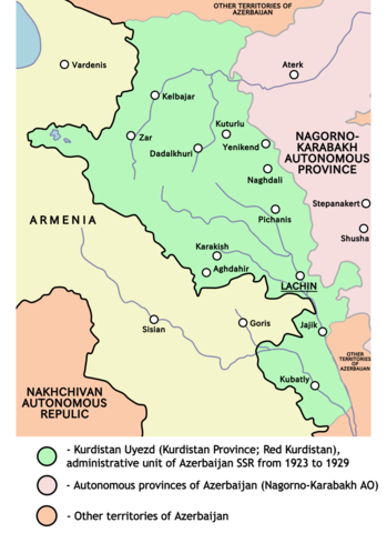
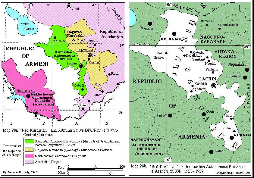
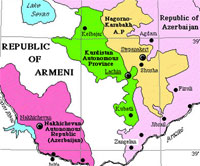
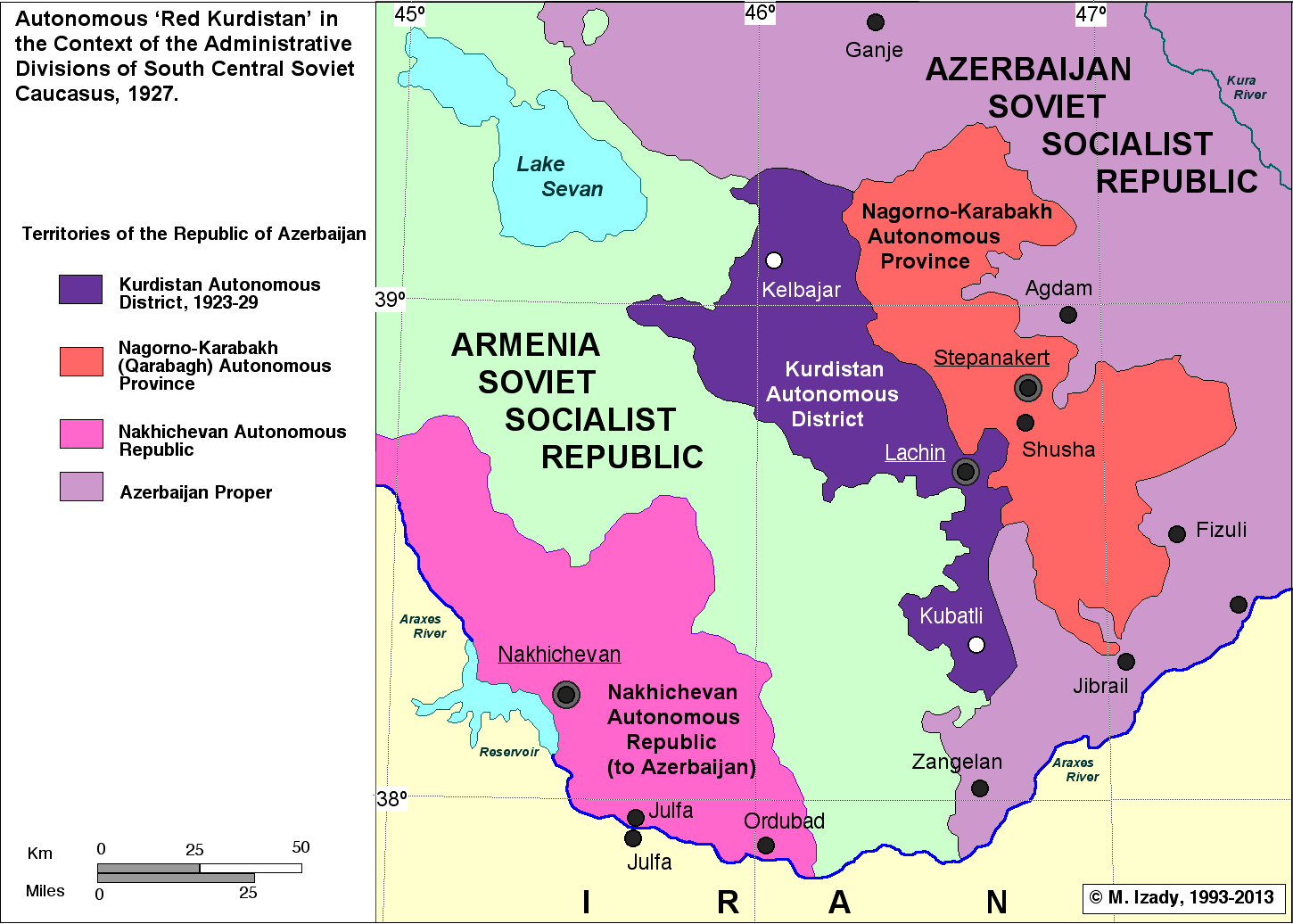
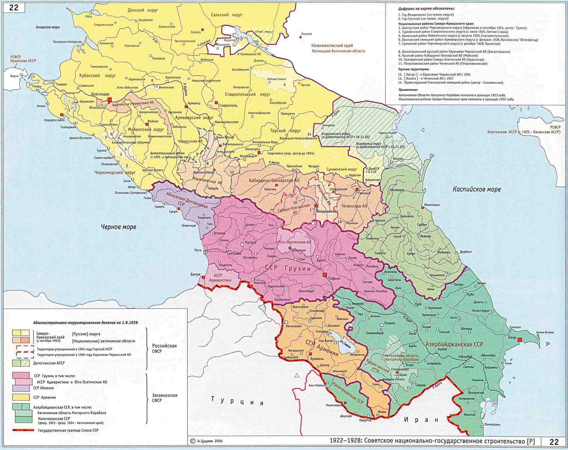
English: Map of Kurdistan Uyezd (Red Kurdistan, Kurdistan Autonomous Province) from 1923 to 1929 (borders according to the Kurdish historian Mehrdad Izady). |
| Mənbə | Öz işi |
| Müəllif | PANONIAN |
Lisenziya
I, the copyright holder of this work, hereby publish it under the following license:
| This file is made available under the Creative Commons CC0 1.0 Universal Public Domain Dedication. | |
| The person who associated a work with this deed has dedicated the work to the public domain by waiving all of their rights to the work worldwide under copyright law, including all related and neighboring rights, to the extent allowed by law. You can copy, modify, distribute and perform the work, even for commercial purposes, all without asking permission.
|
References
Main references - historical maps:
- http://www.institutkurde.org/images/cartes_and_maps/red_kurdistan.jpg (Historical map created by professor Mehrdad R. Izady, one of the most prominent native Kurdish historians. Izady finished his BA degree in History, Political Science and Geography at Kansas State University in 1976.)
- http://modersmal.skolutveckling.se/nordkurdiska/kurdmap/images/Red%20Kurdistan-and%20Administrative%20Division%20of%20Southcentral%20Caucasus_gif_gif.jpg
- http://pukmedia.co/russi/images/stories/gallery/dr-messsr/red_kurdistan.jpg
- http://www.kurdmedia.com/pix/kurdistan_map_red_main.jpg
- http://gulf2000.columbia.edu/images/maps/Caucasus_and_the_Soviet_Red_Kurdistan_lg.jpg
- http://smi2.ru/data/images/385795.jpeg
- http://www.iriston.com/books/cuciev_-_etno_atlas/maps/map22.jpg
References that mention Red Kurdistan:
- Levon Chorbajian, Patrick Donabédian, Claude Mutafian, The Caucasian knot: the history & geopolitics of Nagorno-Karabagh, Zed Books, 1994, page 140.
- Charlotte Hille, State Building and Conflict Resolution in the Caucasus, BRILL, 2010, page 200.
- Christopher J. Walker, Armenia and Karabagh: the struggle for unity, Minority Rights Group, 1991, page 114.
References that mention Kurdish Autonomous Province:
- Lokman I. Meho, The Kurds and Kurdistan: a selective and annotated bibliography, ABC-CLIO, 1997, page 17.
- David McDowall, A modern history of the Kurds, I.B.Tauris, 2000, page 492.
References that mention Kurdistan Uyezd (Русский: Курдистанский уезд):
- Территориальное и административное деление Союза ССР на 1-е января 1926 года. Народный комиссариат внутренних дел Статический Отдел. Издательства Главного Управления Коммунального Хозяйства НКВД. Москва - 1926. С. 191. (Territorial and administrative division of the USSR for 1st January 1926. Publishing house of NKVD. Page. 191) (For downloading book in 5 parts of WinDjView file СССР - январь 1926 г. )
- Central Asia and The Caucasus, Information and Analytical Center, 2003, Issues 22-24, page 75.
- United States. Foreign Broadcast Information Service, Daily report: Soviet Union, Issues 147-153, The Service, 1990, page 49.
This image has been assessed using the Quality image guidelines and is considered a Quality image.
|
Faylın tarixçəsi
Faylın əvvəlki versiyasını görmək üçün gün/tarix bölməsindəki tarixlərə klikləyin.
| Tarix/Vaxt | Kiçik şəkil | Ölçülər | İstifadəçi | Şərh | |
|---|---|---|---|---|---|
| indiki | 17:27, 21 sentyabr 2021 | | 1.205 × 1.659 (396 KB) | Golden | fixed the borders (they were almost completely wrong); added rivers; used anti-aliasing |
| 14:40, 12 aprel 2011 |  | 530 × 807 (58 KB) | PANONIAN | Changing main term to "Kurdistan Uyezd" to make Azeri users happy. However, two other terms (Red Kurdistan and Kurdistan Autonomous Province) should remain at least in parenthesis | |
| 20:18, 9 aprel 2011 |  | 530 × 807 (58 KB) | PANONIAN | new version, changed some descriptions per suggestions | |
| 15:59, 7 aprel 2011 |  | 530 × 807 (57 KB) | PANONIAN | {{Information |Description ={{en|1=Map of Kurdistan Autonomous Province (Red Kurdistan) from 1923 to 1929.}} |Source ={{own}} |Author =PANONIAN |Date = |Permission = |other_versions = }} |
Fayl keçidləri
Aşağıdakı səhifə bu faylı istifadə edir:
Faylın qlobal istifadəsi
Bu fayl aşağıdakı vikilərdə istifadə olunur:
- ar.wikipedia.org layihəsində istifadəsi
- arz.wikipedia.org layihəsində istifadəsi
- azb.wikipedia.org layihəsində istifadəsi
- br.wikipedia.org layihəsində istifadəsi
- ckb.wikipedia.org layihəsində istifadəsi
- de.wikipedia.org layihəsində istifadəsi
- diq.wikipedia.org layihəsində istifadəsi
- en.wikipedia.org layihəsində istifadəsi
- es.wikipedia.org layihəsində istifadəsi
- fa.wikipedia.org layihəsində istifadəsi
- fi.wikipedia.org layihəsində istifadəsi
- fr.wikipedia.org layihəsində istifadəsi
- Kurdistan rouge
- Discussion:Kurdistan rouge
- Utilisateur:GhosterBot/BacASable/Le saviez-vous ?/Archives
- Wikipédia:Le saviez-vous ?/Archives/2023
- Liste de dynasties, d'États et de divisions administratives kurdes
- Discussion:Kurdistan rouge/LSV 21861
- Wikipédia:Statistiques des anecdotes de la page d'accueil/Visibilité des anecdotes (2023)
- Wikipédia:Wikimag/2023/28
- Wikipédia:Statistiques des anecdotes de la page d'accueil/Visibilité des anecdotes (2023)/2023 07
- Projet:Aide et accueil/Twitter/Tweets/archives/juillet 2023
- he.wikipedia.org layihəsində istifadəsi
- it.wikipedia.org layihəsində istifadəsi
- ja.wikipedia.org layihəsində istifadəsi
- ku.wikipedia.org layihəsində istifadəsi
- pl.wikipedia.org layihəsində istifadəsi
- pt.wikipedia.org layihəsində istifadəsi
- ru.wikipedia.org layihəsində istifadəsi
- sh.wikipedia.org layihəsində istifadəsi
- sr.wikipedia.org layihəsində istifadəsi
- sv.wikipedia.org layihəsində istifadəsi
- tr.wikipedia.org layihəsində istifadəsi
- uk.wikipedia.org layihəsində istifadəsi
Bu faylın qlobal istifadəsinə baxın.