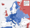
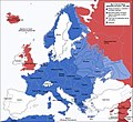
Fayl:Second world war europe 1941-1942 map en.png

Vikipediya, azad ensiklopediya
Naviqasiyaya keçin Axtarışa keçin

Faylın orijinalı(1.090 × 1.000 piksel, fayl həcmi: 216 KB, MIME növü: image/png)

Bu fayl "Vikimedia Commons"dadır
və digər layihələrdə istifadə edilə bilər.
təsvir səhifəsi
təsvir səhifəsi
Faylın təsvir səhifəsinə get
This military map image could be re-created using vector graphics as an SVG file. This has several advantages; see Commons:Media for cleanup for more information. If an SVG form of this image is available, please upload it and afterwards replace this template with {{vector version available|new image name}}.


It is recommended to name the SVG file “Second world war europe 1941-1942 map en.svg”—then the template Vector version available (or Vva) does not need the new image name parameter.
Maps of the history of Europe
BCE
aC

Weichselian ice age (c. 113,000–9700) · Neolithic expansion (c. 7000–4500) · Middle Neolithic (c. 4500–4000) · Late Neolithic (c. 4000–3000) · Copper Age – Corded Ware culture (c. 2900–2350) · Copper Age – Bellbeaker culture (c. 2800–1800) · Early Bronze Age – Unetice culture (c. 2300–1600) · Late Bronze Age – Urnfield culture (c. 1300—750) · Migrations (c. 1000–100) · Hallstatt & La Tène cultures (c. 800–100) · Roman Republic (510–40) · 220 · 218 · 200 · 201–100 · 58 · 49 · 39 · 30 BCE–6 CE


CE
dC

14 · 14–37 · 60 · 60 · 69 · 80 · Migrations 100–500 · 117 · 117 · 125 · Migrations 150–774 · Economy 180 · 271 · 293–305 · 337 · 395 · c. 395 · 400 · 400 · 450 · 457–61 · 476 · 480 · Franks 481–814 · Early Slavs 500–700 · 500 · 526 · 526–600 · Christianisation to 600 · c. 550 · 650 · Pontic Steppe 650 · 665 · 800 · Vikings 800–1050 · 814 · 843–70 · 850 · 900 · 912 · 998 · 1000 · 1000 · 1054 · 1092 · First Crusade 1095–99 · 1097 · 1135 · 1142 · 1147–49 · 1190 · 1190 · 1250 · c. 1250 · 1301-1400 · 1301-1400 · 1328 · 1345 · Black Plague 1347–51 · 1360 · 1400 · Trade routes c. 1400 · 1430 · 1470 · 1490 · 1492 · 1500 · 1519 · 1550 · 1560 · Religion 1560 · Religion 1600 · Religion 1618 · 1618–48 · 1648 · 1683 · 1700 · 1701 · 1708 · 1714 · 1721 · 1725–30 · 1739–1740 · 1740 · 1748–66 · 1783–1792 · 1787 · 1787 · 1789 · 1799 · 1812 · 1812 · 1812 · 1812 · 1813 · 1815 · 1815 · 1815 · 1818 · Ottoman Empire 1830–1923 · 1848–49 · 1861 · 1867 · 1871 · 1878 · 1890 · 1905 · 1911 · 1914 · 1914 · 1919 · 1919–29 · 1923 · 1929 · 1930 · 1940 · 1941–42 · 1942–45 · Cold War 1947–91 · 1950 · 1993–2006 · 2006 to date

(this template: · view · discuss )

Xülasə

Annotations
InfoField
This image is annotated: View the annotations at Commons
İzah
Deutsch: Karte der vom Deutschen Reich besetzten Gebiete und der Kriegsfronten im Zweiten Weltkrieg, 1941/42.
English: A map of German front of the Second World War circa 1941-1942.
Ελληνικά: Εδαφικές κατακτήσεις του Ράιχ
Español: Conquistas territoriales del Reich
Tarix Original Image: 17 April 2005
Derivative Image: 22 December 2005
Mənbə This file was derived from: Second world war europe 1941-1942 map de.png
Müəllif Original Author: User:San Jose
Derivative Author: User:ArmadniGeneral
İcazə
(Faylın təkrar istifadəsi)
This image is a translation of the original, created and released under the terms of the GNU Free Documentation License.
Digər versiyalar

Derivative works of this file:  Großdeutsches Reich-europe.png [redaktə]

Lisenziya

GNU head Bu sənədi GNU Azad Sənədləşdirmə Lisenziyası, Versiya 1.2 və ya Azad Proqram Fondu tərəfindən nəşr olunan hər hansı sonrakı versiya şərtlərinə əsasən dəyişməz bölmələr, ön qapaq mətnləri və arxa qapaq mətnləri olmadan köçürmək, yayımlamaq və / və ya dəyişdirmək üçün icazə verilir; Lisenziyanın bir nüsxəsi GNU Azad Sənədləşdirmə Lisenziyası adlı hissəyə daxil edilmişdir.
w:az:Creative Commons
istinad bənzər paylaşma
Bu fayl Creative Commons Attribution-Share Alike 3.0 Unported lisenziyası altında yayımlanır.
Azadsınız:
  • paylaşmaq – əsəri köçürmək, paylamaq və ötürmək üçün
  • remiks etmək – əsəri adaptasiya etmək
Aşağıdakı şərtlərə riayət etməklə:
  • istinad – Müvafiq kredit verməlisiniz, lisenziyaya bir keçid verməlisiniz və dəyişikliklərin olub olmadığını bildirməlisiniz. Bunu hər hansı bir ağlabatan şəkildə edə bilərsiniz, ancaq lisenziyalaşdırıcının sizi və ya istifadənizi təsdiqləməsini təklif edən bir şəkildə deyil.
  • bənzər paylaşma – Əsəri remix edirsinizsə, dəyişdirirsinizsə və ya üzərində iş aparırsınızsa, öz töhfələrinizi orijinalda olduğu kimi eyni və ya uyğun lisenziya altında yayımlamalısınız.
This licensing tag was added to this file as part of the GFDL licensing update.

Captions

Add a one-line explanation of what this file represents

Items portrayed in this file

təsvir edir

copyrighted ingilis

media type ingilis

image/png

Faylın tarixçəsi

Faylın əvvəlki versiyasını görmək üçün gün/tarix bölməsindəki tarixlərə klikləyin.

Tarix/VaxtKiçik şəkilÖlçülərİstifadəçiŞərh
indiki16:20, 5 avqust 202016:20, 5 avqust 2020 tarixindəki versiyanın kiçildilmiş görüntüsü1.090 × 1.000 (216 KB)Claude ZygielDistinguished statutes
01:00, 28 iyul 201801:00, 28 iyul 2018 tarixindəki versiyanın kiçildilmiş görüntüsü1.090 × 1.000 (184 KB)JeffyPShrinking file size
08:06, 16 fevral 200908:06, 16 fevral 2009 tarixindəki versiyanın kiçildilmiş görüntüsü1.090 × 1.000 (214 KB)Guinnog{{Information |Description=better titles |Source=*File:Second_world_war_europe_1941-1942_map_en.png |Date=2009-02-16 08:05 (UTC) |Author=*File:Second_world_war_europe_1941-1942_map_en.png: Sir Lothar *derivative work: ~~~ |Permission=see below
00:22, 11 aprel 200800:22, 11 aprel 2008 tarixindəki versiyanın kiçildilmiş görüntüsü1.090 × 1.000 (208 KB)Sir Lothar
05:36, 21 dekabr 200505:36, 21 dekabr 2005 tarixindəki versiyanın kiçildilmiş görüntüsü1.090 × 1.000 (221 KB)ArmadniGeneralA map of the Eastern front of the Second World War circa 1941-1942. The original German-language map was created by User:San Jose on 17 April 2005. It can be found here: Image:Second world war europe 1941-1942 map de.png. This image is a translat

Bu faylı istifadə edən səhifə yoxdur.

Faylın qlobal istifadəsi

Bu fayl aşağıdakı vikilərdə istifadə olunur:

Bu faylın qlobal istifadəsinə baxın.

Metaməlumatlar