Fayl:USA Territorial Growth small.gif
Naviqasiyaya keçin
Axtarışa keçin
Daha yüksək versiyası yoxdur.
USA_Territorial_Growth_small.gif (431 × 287 piksel, fayl həcmi: 456 KB, MIME növü: image/gif, ilmələnib, 10 çərçivə, 30 s)
| Bu fayl "Vikimedia Commons"dadır və digər layihələrdə istifadə edilə bilər. |
 |
Faylın təsvir səhifəsinə get |

|
This file has been superseded by USA territorial growth.gif. It is recommended to use the other file. Please note that deleting superseded images requires consent.
|

|
Xülasə
| İzah |
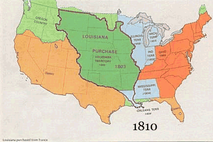
English: US territorial growth 1810–1920, based on the PD USGS maps in Category:Territorial growth maps of the United States.
See key below for explanation of colors.  |
||||||
| Mənbə |
|
||||||
| Müəllif |
|
||||||
| Digər versiyalar |
|
Lisenziya
This image is in the public domain in the United States because it only contains materials that originally came from the United States Geological Survey, an agency of the United States Department of the Interior. For more information, see the official USGS copyright policy.
|
Faylın tarixçəsi
Faylın əvvəlki versiyasını görmək üçün gün/tarix bölməsindəki tarixlərə klikləyin.
| Tarix/Vaxt | Kiçik şəkil | Ölçülər | İstifadəçi | Şərh | |
|---|---|---|---|---|---|
| indiki | 10:50, 30 may 2006 | | 431 × 287 (456 KB) | Roke~commonswiki | US territorial growth, based on the PD USGS maps in Category:USA Territorial Growth Maps Category: USA Territorial Growth Maps {{PD-USGov-USGS}} |
Fayl keçidləri
Bu faylı istifadə edən səhifə yoxdur.
Faylın qlobal istifadəsi
Bu fayl aşağıdakı vikilərdə istifadə olunur:
- ar.wikipedia.org layihəsində istifadəsi
- be-tarask.wikipedia.org layihəsində istifadəsi
- be.wikipedia.org layihəsində istifadəsi
- ca.wikipedia.org layihəsində istifadəsi
- ckb.wikipedia.org layihəsində istifadəsi
- da.wikipedia.org layihəsində istifadəsi
- fr.wikipedia.org layihəsində istifadəsi
- fy.wikipedia.org layihəsində istifadəsi
- gcr.wikipedia.org layihəsində istifadəsi
- hr.wikipedia.org layihəsində istifadəsi
- id.wikipedia.org layihəsində istifadəsi
- it.wikipedia.org layihəsində istifadəsi
- jv.wikipedia.org layihəsində istifadəsi
- kk.wikipedia.org layihəsində istifadəsi
- ro.wikipedia.org layihəsində istifadəsi
- sh.wikipedia.org layihəsində istifadəsi
- sl.wikipedia.org layihəsində istifadəsi
- sr.wikipedia.org layihəsində istifadəsi
- tr.wikipedia.org layihəsində istifadəsi
- uk.wikipedia.org layihəsində istifadəsi