Fayl:Adriatic Plate.jpg
Naviqasiyaya keçin
Axtarışa keçin
Sınaq göstərişi ölçüsü: 626 × 600 piksel. Digər ölçülər: 250 × 240 piksel | 501 × 480 piksel | 817 × 783 piksel.
Faylın orijinalı (817 × 783 piksel, fayl həcmi: 181 KB, MIME növü: image/jpeg)
| Bu fayl "Vikimedia Commons"dadır və digər layihələrdə istifadə edilə bilər. |
 |
Faylın təsvir səhifəsinə get |
Xülasə
| İzah |
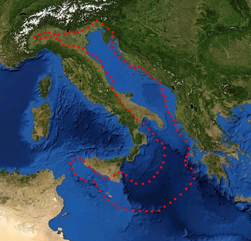
English: boundaries of the Adriatic plate
עברית: גבולות הלוח האדריאטי |
| Tarix | (UTC) |
| Mənbə |
Mediterranian_Sea_16.61811E_38.99124N.jpg (July 2012). "Present kinematics of Central and Northern Italy from continuous GPS measurements". Journal of Geodynamics 58: 62-72. Elsevier. ISSN 0264-3707. Retrieved on 12 March 2012. plate boundary map preview |
| Müəllif |
|
| Bu təsvirin redaktəsi, orijinala əsaslanaraq rəqəmsal qaydadadır. Dəyişiklik: crop, plate boundaries. İlkin təsvir buradadır: Mediterranian Sea 16.61811E 38.99124N.jpg. Redaktə etdi דקי.
|
Lisenziya
| This image is in the public domain because it is a screenshot from NASA’s globe software World Wind using a public domain layer, such as Blue Marble, MODIS, Landsat, SRTM, USGS or GLOBE.
|
 |
| This work was previously under Public Domain, or a Free License. It has been digitally enhanced and/or modified. This derivative work has been (or is hereby) released into the public domain by its author, [[:{{{1}}}:User:{{{3}}}|{{{3}}}]] at the [[:{{{1}}}:|{{{2}}}]] project. This applies worldwide. In some countries this is not legally possible; if so:
|
Orijinal yükləmə gündəliyi
This image is a derivative work of the following images:
- File:Mediterranian_Sea_16.61811E_38.99124N.jpg licensed with PD-WorldWind, PD-retouched-user-w
Uploaded with derivativeFX
Faylın tarixçəsi
Faylın əvvəlki versiyasını görmək üçün gün/tarix bölməsindəki tarixlərə klikləyin.
| Tarix/Vaxt | Kiçik şəkil | Ölçülər | İstifadəçi | Şərh | |
|---|---|---|---|---|---|
| indiki | 17:52, 29 dekabr 2011 | | 817 × 783 (181 KB) | דקי | == {{int:filedesc}} == {{Information |Description={{en|boundaries of the Adriatic plate}} {{he|גבולות הלוח האדריאטי}} |Source=*File:Mediterranian_Sea_16.61811E_38.99124N.jpg |Date=2011-12-29 17:47 (UTC) |Author=*[[:File:Mediterrani |
Fayl keçidləri
Aşağıdakı səhifə bu faylı istifadə edir:
Faylın qlobal istifadəsi
Bu fayl aşağıdakı vikilərdə istifadə olunur:
- bg.wikipedia.org layihəsində istifadəsi
- bn.wikipedia.org layihəsində istifadəsi
- ca.wikipedia.org layihəsində istifadəsi
- cs.wikipedia.org layihəsində istifadəsi
- de.wikipedia.org layihəsində istifadəsi
- el.wikipedia.org layihəsində istifadəsi
- en.wikipedia.org layihəsində istifadəsi
- es.wikipedia.org layihəsində istifadəsi
- fa.wikipedia.org layihəsində istifadəsi
- fr.wikipedia.org layihəsində istifadəsi
- he.wikipedia.org layihəsində istifadəsi
- hr.wikipedia.org layihəsində istifadəsi
- hu.wikipedia.org layihəsində istifadəsi
- it.wikipedia.org layihəsində istifadəsi
- ja.wikipedia.org layihəsində istifadəsi
- nl.wikipedia.org layihəsində istifadəsi
- pl.wikipedia.org layihəsində istifadəsi
- pt.wikipedia.org layihəsində istifadəsi
- ru.wikipedia.org layihəsində istifadəsi
- sh.wikipedia.org layihəsində istifadəsi
- sl.wikipedia.org layihəsində istifadəsi
- sv.wikipedia.org layihəsində istifadəsi
- tr.wikipedia.org layihəsində istifadəsi
- uk.wikipedia.org layihəsində istifadəsi
- zh.wikipedia.org layihəsində istifadəsi