Fayl:B26055943A - A map of the East-Indies and the adjacent countries.jpg
Naviqasiyaya keçin
Axtarışa keçin

Sınaq göstərişi ölçüsü: 800 × 509 piksel. Digər ölçülər: 320 × 204 piksel | 640 × 407 piksel | 1.024 × 652 piksel | 1.280 × 815 piksel | 2.560 × 1.629 piksel | 7.509 × 4.779 piksel.
Faylın orijinalı (7.509 × 4.779 piksel, fayl həcmi: 12,73 MB, MIME növü: image/jpeg)
| Bu fayl "Vikimedia Commons"dadır və digər layihələrdə istifadə edilə bilər. |
 |
Faylın təsvir səhifəsinə get |
Xülasə
| İzah |
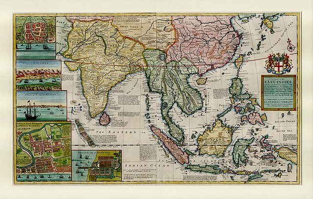
English: This large map by Herman Moll shows the East Indies from the Persian border to New Guinea and the southern part of Japan, including India, Ceylon, southeast Asia, most of China, Indonesia and the Philippines. It illustrates the extent of European influence and trade in the region, at the height of European colonial control. Further map features and detail maps of interest: Batavia, Goa, Mughal Empire, Maldives, Chennai, Banten, Lake Chimay |
| Tarix | |
| Mənbə | NLB Singapore, David Parry Southeast Asian Map Collection. Available on BookSG https://eresources.nlb.gov.sg/printheritage/detail/3957ca10-8863-4f87-9d8c-49cfe590b0cd.aspx |
| Müəllif | Moll, Herman, -1732 |
| Digər versiyalar |


Lisenziya
| This file is made available under the Creative Commons CC0 1.0 Universal Public Domain Dedication. | |
| The person who associated a work with this deed has dedicated the work to the public domain by waiving all of their rights to the work worldwide under copyright law, including all related and neighboring rights, to the extent allowed by law. You can copy, modify, distribute and perform the work, even for commercial purposes, all without asking permission.
|
Faylın tarixçəsi
Faylın əvvəlki versiyasını görmək üçün gün/tarix bölməsindəki tarixlərə klikləyin.
| Tarix/Vaxt | Kiçik şəkil | Ölçülər | İstifadəçi | Şərh | |
|---|---|---|---|---|---|
| indiki | 05:13, 28 dekabr 2021 | | 7.509 × 4.779 (12,73 MB) | NLSingapore | Uploaded a work by Moll, Herman, -1732 from NLB Singapore, David Parry Southeast Asian Map Collection. Available on BookSG https://eresources.nlb.gov.sg/printheritage/detail/3957ca10-8863-4f87-9d8c-49cfe590b0cd.aspx with UploadWizard |
Fayl keçidləri
Aşağıdakı səhifə bu faylı istifadə edir:
Faylın qlobal istifadəsi
Bu fayl aşağıdakı vikilərdə istifadə olunur:
- ar.wikipedia.org layihəsində istifadəsi
- ast.wikipedia.org layihəsində istifadəsi
- be.wikipedia.org layihəsində istifadəsi
- bg.wikipedia.org layihəsində istifadəsi
- br.wikipedia.org layihəsində istifadəsi
- ca.wikipedia.org layihəsində istifadəsi
- cy.wikipedia.org layihəsində istifadəsi
- el.wikipedia.org layihəsində istifadəsi
- eo.wikipedia.org layihəsində istifadəsi
- eu.wikipedia.org layihəsində istifadəsi
- fr.wikipedia.org layihəsində istifadəsi
- ga.wikipedia.org layihəsində istifadəsi
- he.wikipedia.org layihəsində istifadəsi
- hy.wikipedia.org layihəsində istifadəsi
- it.wikipedia.org layihəsində istifadəsi
- uk.wikipedia.org layihəsində istifadəsi
- www.wikidata.org layihəsində istifadəsi