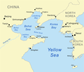
Fayl:Bohaiseamap2.png
Naviqasiyaya keçin
Axtarışa keçin
Bohaiseamap2.png (569 × 487 piksel, fayl həcmi: 136 KB, MIME növü: image/png)
Faylın tarixçəsi
Faylın əvvəlki versiyasını görmək üçün gün/tarix bölməsindəki tarixlərə klikləyin.
| Tarix/Vaxt | Kiçik şəkil | Ölçülər | İstifadəçi | Şərh | |
|---|---|---|---|---|---|
| indiki | 19:33, 7 yanvar 2021 |  | 569 × 487 (136 KB) | Ras67 | black frame cropped and alpha channel removed |
| 14:59, 27 iyun 2007 |  | 583 × 500 (179 KB) | Kmusser | added strait | |
| 14:50, 27 iyun 2007 |  | 500 × 429 (141 KB) | Kmusser | {{Information |Description=Map of the Bohai Sea and surrounding bays. For a more general map of the same area see Image:Bohai Sea map.png |Source=self-made, based on DCW data. |Date=June 27, 2007 |
Fayl keçidləri
Aşağıdakı 2 səhifə bu faylı istifadə edir:
Faylın qlobal istifadəsi
Bu fayl aşağıdakı vikilərdə istifadə olunur:
- af.wikipedia.org layihəsində istifadəsi
- ar.wikipedia.org layihəsində istifadəsi
- ast.wikipedia.org layihəsində istifadəsi
- be.wikipedia.org layihəsində istifadəsi
- bg.wikipedia.org layihəsində istifadəsi
- bn.wikipedia.org layihəsində istifadəsi
- ca.wikipedia.org layihəsində istifadəsi
- cs.wikipedia.org layihəsində istifadəsi
- cy.wikipedia.org layihəsində istifadəsi
- da.wikipedia.org layihəsində istifadəsi
- en.wikipedia.org layihəsində istifadəsi
- en.wikinews.org layihəsində istifadəsi
- eo.wikipedia.org layihəsində istifadəsi
- es.wikipedia.org layihəsində istifadəsi
- eu.wikipedia.org layihəsində istifadəsi
- fa.wikipedia.org layihəsində istifadəsi
- fi.wikipedia.org layihəsində istifadəsi
- frr.wikipedia.org layihəsində istifadəsi
- fr.wikipedia.org layihəsində istifadəsi
- fy.wikipedia.org layihəsində istifadəsi
Bu faylın qlobal istifadəsinə baxın.


