Fayl:DjoudjNASA.jpg
Naviqasiyaya keçin
Axtarışa keçin
Daha yüksək versiyası yoxdur.
DjoudjNASA.jpg (560 × 305 piksel, fayl həcmi: 79 KB, MIME növü: image/jpeg)
| Bu fayl "Vikimedia Commons"dadır və digər layihələrdə istifadə edilə bilər. |
 |
Faylın təsvir səhifəsinə get |
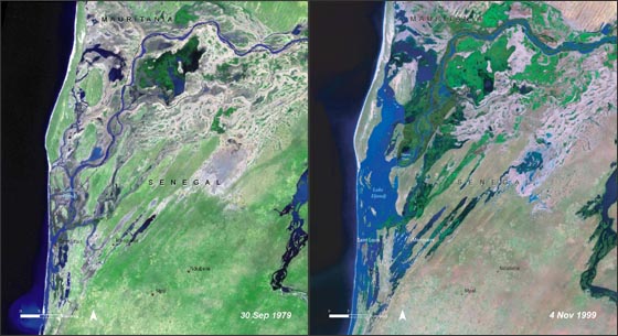
| İzah | Lake Djoudj during the Sept. 1979 drought (left) and during the Nov. 1999 flood (right). http://landsat.gsfc.nasa.gov/images/archive/f0011.html In August 2006, the United Nations Environment Programme (UNEP), released an atlas entitled: "Africa's Lakes: Atlas of Our Changing Environment." The atlas relies heavily on Landsat imagery from the past 34 years to show changes in lakes around the African continent. Above, are two Landsat images of the Djoudj Sanctuary in Senegal that are featured in the atlas. The atlas tell us: "Situated in the Senegal river delta, the Djoudj Sanctuary is a wetland of 16 000 ha, comprising a large lake, referred to as Lake Djoudj in this publication, surrounded by streams, ponds and backwaters. These two images show the Djoudj Sanctuary before and after the construction of the Diama Dam." "The image from September 1979 shows the impact of drought on the Djoudj Sanctuary, while the image from November 1999 shows rejuvenation of the sanctuary wetlands due to the significant floods of that year. The two images vividly depict the impact of climate variability on the Djoudj Sanctuary—and demonstrate the broader need for close monitoring of the impacts of climate variability and climate change on lake environments." |
| Tarix | August 2006 September 1979 November 1999 (5 oktyabr 2006 (according to Exif data)) |
| Mənbə | NASA [1] |
| Müəllif | Naməlum |
| This file is in the public domain in the United States because it was solely created by NASA. NASA copyright policy states that "NASA material is not protected by copyright unless noted". (See Template:PD-USGov, NASA copyright policy page or JPL Image Use Policy.) | ||
 |
Warnings:
|
Faylın tarixçəsi
Faylın əvvəlki versiyasını görmək üçün gün/tarix bölməsindəki tarixlərə klikləyin.
| Tarix/Vaxt | Kiçik şəkil | Ölçülər | İstifadəçi | Şərh | |
|---|---|---|---|---|---|
| indiki | 20:03, 16 avqust 2007 | | 560 × 305 (79 KB) | Ji-Elle | Lake Djoudj during the Sept. 1979 drought (left) and during the Nov. 1999 flood (right). http://landsat.gsfc.nasa.gov/images/archive/f0011.html In August 2006, the United Nations Environment Programme (UNEP), released an atlas entitled: "Africa's Lakes: |
Fayl keçidləri
Aşağıdakı səhifə bu faylı istifadə edir:
Faylın qlobal istifadəsi
Bu fayl aşağıdakı vikilərdə istifadə olunur:
- ar.wikipedia.org layihəsində istifadəsi
- ca.wikipedia.org layihəsində istifadəsi
- en.wikipedia.org layihəsində istifadəsi
- en.wikinews.org layihəsində istifadəsi
- fr.wikipedia.org layihəsində istifadəsi
- hy.wikipedia.org layihəsində istifadəsi
- mt.wikipedia.org layihəsində istifadəsi
- ru.wikipedia.org layihəsində istifadəsi
- ru.wikinews.org layihəsində istifadəsi
- www.wikidata.org layihəsində istifadəsi