Fayl:Europe in 1430.PNG
Naviqasiyaya keçin
Axtarışa keçin
Sınaq göstərişi ölçüsü: 553 × 599 piksel. Digər ölçülər: 221 × 240 piksel | 600 × 650 piksel.
Faylın orijinalı (600 × 650 piksel, fayl həcmi: 69 KB, MIME növü: image/png)
| Bu fayl "Vikimedia Commons"dadır və digər layihələrdə istifadə edilə bilər. |
 |
Faylın təsvir səhifəsinə get |
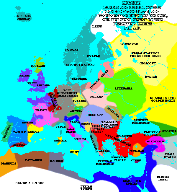
| İzah | A map of Europe in 1430. | ||
| Mənbə | [1] | ||
| Müəllif | Lynn H. Nelson | ||
| İcazə (Faylın təkrar istifadəsi) |
|
_en.png)
.png)
.jpg)
Faylın tarixçəsi
Faylın əvvəlki versiyasını görmək üçün gün/tarix bölməsindəki tarixlərə klikləyin.
| Tarix/Vaxt | Kiçik şəkil | Ölçülər | İstifadəçi | Şərh | |
|---|---|---|---|---|---|
| indiki | 20:16, 10 may 2020 | | 600 × 650 (69 KB) | Santasa99 | Per John V.A. Fine: The Late Medieval Balkans: A Critical Survey from the Late Twelfth Century to the Ottoman Conquest; Chapter 9. The Balkans in the Early Fifteenth Century - Bosnia after death of Tvrtko |
| 19:30, 8 mart 2005 |  | 600 × 650 (44 KB) | Quadell | A map of Europe in 1430.{{PD}}Source:[http://www.ku.edu/kansas/medieval/108/lectures/]Category:Maps of EuropeCategory:Historical mapsCategory:1430 |
Fayl keçidləri
Aşağıdakı səhifə bu faylı istifadə edir:
Faylın qlobal istifadəsi
Bu fayl aşağıdakı vikilərdə istifadə olunur:
- ar.wikipedia.org layihəsində istifadəsi
- ba.wikipedia.org layihəsində istifadəsi
- bg.wikipedia.org layihəsində istifadəsi
- bn.wikipedia.org layihəsində istifadəsi
- bxr.wikipedia.org layihəsində istifadəsi
- ca.wikipedia.org layihəsində istifadəsi
- cs.wikipedia.org layihəsində istifadəsi
- de.wikipedia.org layihəsində istifadəsi
- el.wikipedia.org layihəsində istifadəsi
- en.wikipedia.org layihəsində istifadəsi
- en.wikibooks.org layihəsində istifadəsi
- es.wikipedia.org layihəsində istifadəsi
- fa.wikipedia.org layihəsində istifadəsi
- fi.wikipedia.org layihəsində istifadəsi
- fr.wikipedia.org layihəsində istifadəsi
- id.wikipedia.org layihəsində istifadəsi
- io.wikipedia.org layihəsində istifadəsi
- is.wikipedia.org layihəsində istifadəsi
- ka.wikipedia.org layihəsində istifadəsi
- mk.wikipedia.org layihəsində istifadəsi
- nds-nl.wikipedia.org layihəsində istifadəsi
- nl.wikipedia.org layihəsində istifadəsi
- nn.wikipedia.org layihəsində istifadəsi
- no.wikipedia.org layihəsində istifadəsi
- pnb.wikipedia.org layihəsində istifadəsi
- pt.wikipedia.org layihəsində istifadəsi
- ru.wikipedia.org layihəsində istifadəsi
- sa.wikipedia.org layihəsində istifadəsi
- scn.wikipedia.org layihəsində istifadəsi
- sh.wikipedia.org layihəsində istifadəsi
- simple.wikipedia.org layihəsində istifadəsi
- skr.wikipedia.org layihəsində istifadəsi
- sk.wikipedia.org layihəsində istifadəsi
Bu faylın qlobal istifadəsinə baxın.