Fayl:Henrietta Island, Russia.jpg
Naviqasiyaya keçin
Axtarışa keçin

Sınaq göstərişi ölçüsü: 600 × 600 piksel. Digər ölçülər: 240 × 240 piksel | 480 × 480 piksel | 768 × 768 piksel | 1.024 × 1.024 piksel | 2.000 × 2.000 piksel.
Faylın orijinalı (2.000 × 2.000 piksel, fayl həcmi: 2,22 MB, MIME növü: image/jpeg)
| Bu fayl "Vikimedia Commons"dadır və digər layihələrdə istifadə edilə bilər. |
 |
Faylın təsvir səhifəsinə get |
Xülasə
| İzah |
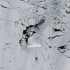
English: The Advanced Land Imager (ALI) on NASA’s Earth Observing-1 satellite captured this image of Henrietta Island. In this natural-color image, the island casts shadows to the north, thanks to the Sun’s low angle and the island’s own steep, rugged coastline. Inland, an icy dome covers most of the island, its southern surface slightly illuminated. |
| Tarix | |
| Mənbə | NASA Earth Observatory |
| Müəllif | Jesse Allen |
Instrument: EO-1 - ALI
Lisenziya
| This file is in the public domain in the United States because it was solely created by NASA. NASA copyright policy states that "NASA material is not protected by copyright unless noted". (See Template:PD-USGov, NASA copyright policy page or JPL Image Use Policy.) | ||
 |
Warnings:
|
| Annotations | This image is annotated: View the annotations at Commons |
Faylın tarixçəsi
Faylın əvvəlki versiyasını görmək üçün gün/tarix bölməsindəki tarixlərə klikləyin.
| Tarix/Vaxt | Kiçik şəkil | Ölçülər | İstifadəçi | Şərh | |
|---|---|---|---|---|---|
| indiki | 11:23, 23 may 2009 | | 2.000 × 2.000 (2,22 MB) | Originalwana | {{Information |Description={{en|1=The Advanced Land Imager (ALI) on NASA’s Earth Observing-1 satellite captured this image of Henrietta Island. In this natural-color image, the island casts shadows to the north, thanks to the Sun’s low angle and the i |
Fayl keçidləri
Aşağıdakı səhifə bu faylı istifadə edir:
Faylın qlobal istifadəsi
Bu fayl aşağıdakı vikilərdə istifadə olunur:
- be.wikipedia.org layihəsində istifadəsi
- de.wikipedia.org layihəsində istifadəsi
- en.wikipedia.org layihəsində istifadəsi
- he.wikipedia.org layihəsində istifadəsi
- it.wikipedia.org layihəsində istifadəsi
- ka.wikipedia.org layihəsində istifadəsi
- lt.wikipedia.org layihəsində istifadəsi
- mwl.wikipedia.org layihəsində istifadəsi
- pl.wikipedia.org layihəsində istifadəsi
- ru.wikipedia.org layihəsində istifadəsi