Fayl:Iceberg A22A, South Atlantic Ocean.jpg
Naviqasiyaya keçin
Axtarışa keçin

Sınaq göstərişi ölçüsü: 800 × 530 piksel. Digər ölçülər: 320 × 212 piksel | 640 × 424 piksel | 1.024 × 678 piksel | 1.280 × 848 piksel | 2.345 × 1.553 piksel.
Faylın orijinalı (2.345 × 1.553 piksel, fayl həcmi: 793 KB, MIME növü: image/jpeg)
| Bu fayl "Vikimedia Commons"dadır və digər layihələrdə istifadə edilə bilər. |
 |
Faylın təsvir səhifəsinə get |
Xülasə
| İzah |
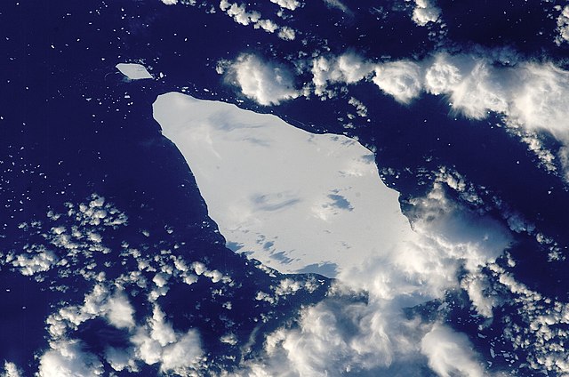
English: This astronaut photograph illustrates the remains of a giant iceberg—designated A22A— that broke off Antarctica in 2002. The iceberg was photographed at a location of 49.9 degrees south latitude, 23.8 degrees west longitude, which is about a third of the distance from South America towards Cape Town, South Africa. A22A is one of the largest icebergs to drift as far north as 50 degrees south latitude, bringing it beneath the daylight path of the International Space Station (ISS). Crew members aboard the ISS were able to locate the ice mass and photograph it, despite the great masses of clouds that often accompany winter storms in the Southern Ocean. The crew’s viewing angle was oblique (not looking straight down) from a point to the west of the berg, and the time of day was early afternoon, as shown by the orientation of the cloud shadows. Dimensions of A22A in early June were 49.9 by 23.4 kilometres, giving it an area of 622 square kilometres, or seven times the area of Manhattan Island.
|
||||||||||||||||||||||||||||||||||||||||||||||||||
| Tarix | |||||||||||||||||||||||||||||||||||||||||||||||||||
| Mənbə | {{URL|example.com|optional display text}} | ||||||||||||||||||||||||||||||||||||||||||||||||||
| Müəllif | Image provided by the ISS Crew Earth Observations experiment and the Image Science & Analysis Laboratory, NASA - Johnson Space Center. | ||||||||||||||||||||||||||||||||||||||||||||||||||
| Object location | | View this and other nearby images on: OpenStreetMap |
|---|
This image or video was catalogued by Johnson Space Center of the United States National Aeronautics and Space Administration (NASA) under Photo ID: ISS015-E-10125. This tag does not indicate the copyright status of the attached work. A normal copyright tag is still required. See Commons:Licensing. Other languages:
|
Lisenziya
| This file is in the public domain in the United States because it was solely created by NASA. NASA copyright policy states that "NASA material is not protected by copyright unless noted". (See Template:PD-USGov, NASA copyright policy page or JPL Image Use Policy.) | ||
 |
Warnings:
|
Faylın tarixçəsi
Faylın əvvəlki versiyasını görmək üçün gün/tarix bölməsindəki tarixlərə klikləyin.
| Tarix/Vaxt | Kiçik şəkil | Ölçülər | İstifadəçi | Şərh | |
|---|---|---|---|---|---|
| indiki | 15:25, 22 mart 2013 | | 2.345 × 1.553 (793 KB) | Julian Herzog | Higher resolution and quality |
| 19:54, 5 iyul 2009 |  | 1.000 × 1.000 (376 KB) | Originalwana | {{Information |Description={{en|1=This astronaut photograph illustrates the remains of a giant iceberg—designated A22A— that broke off Antarctica in 2002. The iceberg was photographed at a location of 49.9 degrees south latitude, 23.8 degrees west lon |
Fayl keçidləri
Aşağıdakı səhifə bu faylı istifadə edir:
Faylın qlobal istifadəsi
Bu fayl aşağıdakı vikilərdə istifadə olunur:
- ar.wikipedia.org layihəsində istifadəsi
- bn.wikipedia.org layihəsində istifadəsi
- cy.wikipedia.org layihəsində istifadəsi
- en.wikipedia.org layihəsində istifadəsi
- eo.wikipedia.org layihəsində istifadəsi
- it.wikipedia.org layihəsində istifadəsi
- it.wikibooks.org layihəsində istifadəsi
- it.wikiversity.org layihəsində istifadəsi
- la.wikipedia.org layihəsində istifadəsi
- mk.wikipedia.org layihəsində istifadəsi
- pt.wikipedia.org layihəsində istifadəsi
- sl.wikipedia.org layihəsində istifadəsi
- ta.wikipedia.org layihəsində istifadəsi
- ta.wiktionary.org layihəsində istifadəsi
- th.wikipedia.org layihəsində istifadəsi