Fayl:Kastamonu districts.png
Naviqasiyaya keçin
Axtarışa keçin
Sınaq göstərişi ölçüsü: 776 × 600 piksel. Digər ölçülər: 311 × 240 piksel | 621 × 480 piksel | 994 × 768 piksel | 1.056 × 816 piksel.
Faylın orijinalı (1.056 × 816 piksel, fayl həcmi: 39 KB, MIME növü: image/png)
| Bu fayl "Vikimedia Commons"dadır və digər layihələrdə istifadə edilə bilər. |
 |
Faylın təsvir səhifəsinə get |
Xülasə
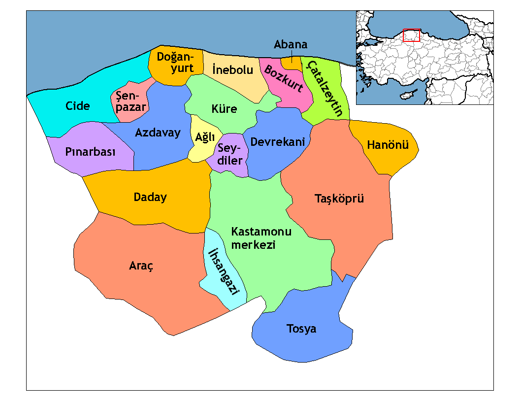
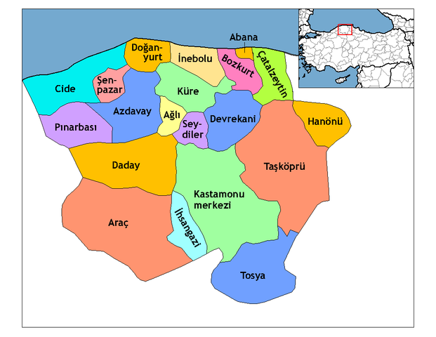
| İzah | Map of the districts of Kastamonu province in Turkey. Created by Rarelibra 21:59, 1 December 2006 (UTC) for public domain use, using MapInfo Professional v8.5 and various mapping resources. Edited by One Homo Sapiens Corrected text where İ,Ş,ı,ğ,or ş occurs in name. Source: [statoids-com]. Increased font size and enhanced color differences among adjacent districts. |
| Tarix | 1 dekabr 2006 (original upload date) |
| Mənbə | No machine-readable source provided. Own work assumed (based on copyright claims). |
| Müəllif | No machine-readable author provided. Rarelibra assumed (based on copyright claims). |

|
This locator map image could be re-created using vector graphics as an SVG file. This has several advantages; see Commons:Media for cleanup for more information. If an SVG form of this image is available, please upload it and afterwards replace this template with
{{vector version available|new image name}}.
It is recommended to name the SVG file “Kastamonu districts.svg”—then the template Vector version available (or Vva) does not need the new image name parameter. |
Lisenziya
| Mən, bu əsərin müəllif hüquqlarının sahibi kimi, əsəri ictimai mülkiyyətə verirəm. Bu icazə bütün dünyada qüvvədədir. In some countries this may not be legally possible; if so: Bunun qanunla mümkün olmadığı hallarda: İstənilən şəxsə, istənilən məqsəd üçün, qanunlar tərəfindən qadağan edilməyincə, heç bir şərt qoymadan bu işdən istifadə haqqını bağışlayıram. |
[[Category:
]]
Faylın tarixçəsi
Faylın əvvəlki versiyasını görmək üçün gün/tarix bölməsindəki tarixlərə klikləyin.
| Tarix/Vaxt | Kiçik şəkil | Ölçülər | İstifadəçi | Şərh | |
|---|---|---|---|---|---|
| indiki | 23:52, 28 dekabr 2008 | | 1.056 × 816 (39 KB) | One Homo Sapiens | Corrected text where İ,Ş,ı,ğ,or ş occurs in name. Source: [statoids-com]. Increased font size and enhanced color differences among adjacent districts. |
| 21:59, 1 dekabr 2006 |  | 1.056 × 816 (37 KB) | Rarelibra | Map of the districts of Kastamonu province in Turkey. Created by ~~~~ for public domain use, using MapInfo Professional v8.5 and various mapping resources. |
Fayl keçidləri
Faylın qlobal istifadəsi
Bu fayl aşağıdakı vikilərdə istifadə olunur:
- ar.wikipedia.org layihəsində istifadəsi
- arz.wikipedia.org layihəsində istifadəsi
- ast.wikipedia.org layihəsində istifadəsi
- av.wikipedia.org layihəsində istifadəsi
- azb.wikipedia.org layihəsində istifadəsi
- ca.wikipedia.org layihəsində istifadəsi
- de.wikipedia.org layihəsində istifadəsi
- diq.wikipedia.org layihəsində istifadəsi
- el.wikipedia.org layihəsində istifadəsi
- en.wikipedia.org layihəsində istifadəsi
- Kastamonu Province
- User talk:Rarelibra/Maps4
- Districts of Turkey
- Governor of Kastamonu
- List of populated places in Kastamonu Province
- Abana District
- Ağlı District
- Kastamonu District
- Araç District
- Azdavay District
- Bozkurt District, Kastamonu
- Çatalzeytin District
- Cide District
- Daday District
- Devrekani District
- Doğanyurt District
- Hanönü District
- İhsangazi District
- İnebolu District
- Küre District
Bu faylın qlobal istifadəsinə baxın.