Fayl:Lithuania territory 1939-1940.svg
Naviqasiyaya keçin
Axtarışa keçin

Bu SVG-faylın PNG formatındakı bu görünüşünün ölçüsü: 761 × 600 piksel. Digər ölçülər: 305 × 240 piksel | 609 × 480 piksel | 974 × 768 piksel | 1.280 × 1.009 piksel | 2.560 × 2.018 piksel | 2.479 × 1.954 piksel.
Faylın orijinalı (SVG faylı, nominal olaraq 2.479 × 1.954 piksel, faylın ölçüsü: 211 KB)
| Bu fayl "Vikimedia Commons"dadır və digər layihələrdə istifadə edilə bilər. |
 |
Faylın təsvir səhifəsinə get |
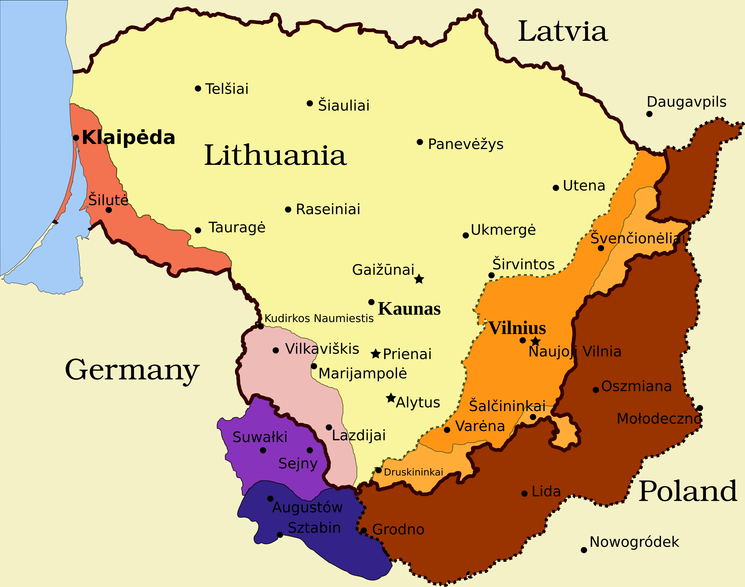
Legend
- Borders and other
Border of Lithuania (1945 – present)
Border of Vilnius Region: Polish territory; claimed by Lithuania based on the Soviet–Lithuania Peace Treaty of 1920; occupied by the Soviet Union in September 1939
![]() Soviet military bases established in Lithuania according to the Soviet–Lithuania Mutual Assistance Treaty, signed on October 10, 1939
Soviet military bases established in Lithuania according to the Soviet–Lithuania Mutual Assistance Treaty, signed on October 10, 1939
- Klaipėda Region
Klaipėda Region: detached from the German Empire by the Treaty of Versailles; placed under administration of the Entente; taken by Lithuanians during the Klaipėda Revolt in January 1923; returned to Nazi Germany after an ultimatum on March 20, 1939
- Sudovia
Territory west of the Šešupė River: Lithuanian territory; requested by Nazi Germany in the German-Soviet Boundary and Friendship Treaty on September 28, 1939; occupied by the Soviet Union on June 15, 1940; Nazi Germany relinquished its claims for a compensation in the amount of $7.5 million on January 10, 1941
"Suwałki Triangle": Polish territory; claimed by Lithuania; occupied by Nazi Germany in September 1939
Southern Suvalkai Region: Polish territory; claimed by Lithuania; occupied by the Soviet Union in September 1939
Vilnius Region
Western Vilnius Region: transferred to Lithuania based on the Soviet–Lithuania Mutual Assistance Treaty, signed on October 10, 1939
Western Vilnius Region: transferred to Lithuanian SSR on November 6, 1940
Eastern Vilnius Region: by Soviet–Lithuanian Peace Treaty assigned to Lithuania in July 12, 1920
Xülasə
| İzah | Map of territorial disputes and claims regarding Lithuania in 1939-1940 |
| Tarix | |
| Mənbə | Self-made using Inkscape; used Image:LithuaniaPhysicalMap-Clean.svg by Knutux for some background features; Source map: (2001) Lietuvos istorijos atlasas, Vilnius: Vaga, p. 44 & 45 |
| Müəllif |
This W3C-unspecified vector image was created with Inkscape . |
| İcazə (Faylın təkrar istifadəsi) |
GFDL & all CC-BY-SA |
| Digər versiyalar |
[]
|


Lisenziya
I, the copyright holder of this work, hereby publish it under the following licenses:

|
Bu sənədi GNU Azad Sənədləşdirmə Lisenziyası, Versiya 1.2 və ya Azad Proqram Fondu tərəfindən nəşr olunan hər hansı sonrakı versiya şərtlərinə əsasən dəyişməz bölmələr, ön qapaq mətnləri və arxa qapaq mətnləri olmadan köçürmək, yayımlamaq və / və ya dəyişdirmək üçün icazə verilir; Lisenziyanın bir nüsxəsi GNU Azad Sənədləşdirmə Lisenziyası adlı hissəyə daxil edilmişdir. |
This file is licensed under the Creative Commons Attribution-Share Alike 4.0 International, 3.0 Unported, 2.5 Generic, 2.0 Generic and 1.0 Generic license.
- Azadsınız:
- paylaşmaq – əsəri köçürmək, paylamaq və ötürmək üçün
- remiks etmək – əsəri adaptasiya etmək
- Aşağıdakı şərtlərə riayət etməklə:
- istinad – Müvafiq kredit verməlisiniz, lisenziyaya bir keçid verməlisiniz və dəyişikliklərin olub olmadığını bildirməlisiniz. Bunu hər hansı bir ağlabatan şəkildə edə bilərsiniz, ancaq lisenziyalaşdırıcının sizi və ya istifadənizi təsdiqləməsini təklif edən bir şəkildə deyil.
- bənzər paylaşma – Əsəri remix edirsinizsə, dəyişdirirsinizsə və ya üzərində iş aparırsınızsa, öz töhfələrinizi orijinalda olduğu kimi eyni və ya uyğun lisenziya altında yayımlamalısınız.
İstədiyiniz lisenziyanı seçə bilərsiniz.
Faylın tarixçəsi
Faylın əvvəlki versiyasını görmək üçün gün/tarix bölməsindəki tarixlərə klikləyin.
| Tarix/Vaxt | Kiçik şəkil | Ölçülər | İstifadəçi | Şərh | |
|---|---|---|---|---|---|
| indiki | 11:13, 27 mart 2024 | | 2.479 × 1.954 (211 KB) | X3SNW8 | File uploaded using svgtranslate tool (https://svgtranslate.toolforge.org/). Added translation for it. |
| 14:38, 20 avqust 2010 |  | 2.479 × 1.954 (207 KB) | Tomasz Bladyniec | 1. There was an error in the name of one of villages. "Graizunai" should be "Gaizunai". 2. If the southeastern territory is decribed as Poland, names of cities should be in Polish then, as they were those times. 3. There's no need to write "Nazi Germany". | |
| 22:35, 30 mart 2008 |  | 2.479 × 1.954 (203 KB) | Renata3 | get rid of legend - too bulky in articles | |
| 21:35, 30 mart 2008 |  | 3.290 × 1.954 (226 KB) | Fvasconcellos | layers | |
| 14:22, 29 mart 2008 |  | 3.290 × 1.954 (223 KB) | Fvasconcellos | font fixes | |
| 14:10, 29 mart 2008 |  | 3.290 × 1.954 (210 KB) | Fvasconcellos | one more attempt | |
| 16:58, 28 mart 2008 |  | 3.290 × 1.954 (226 KB) | Mangwanani | tried to fix image | |
| 16:28, 28 mart 2008 |  | 3.290 × 1.954 (226 KB) | Renata3 | {{Information |Description=Map of territorial disputes and claims regarding Lithuania in 1939-1940 |Source=Self-made using Inkscape; used Image:LithuaniaPhysicalMap-Clean.svg by Knutux for some background features; Source map: (2001) ''Lietuvos istor |
Fayl keçidləri
Aşağıdakı səhifə bu faylı istifadə edir:
Faylın qlobal istifadəsi
Bu fayl aşağıdakı vikilərdə istifadə olunur:
- ar.wikipedia.org layihəsində istifadəsi
- be-tarask.wikipedia.org layihəsində istifadəsi
- be.wikipedia.org layihəsində istifadəsi
- bg.wikipedia.org layihəsində istifadəsi
- bn.wikipedia.org layihəsində istifadəsi
- ca.wikipedia.org layihəsində istifadəsi
- cs.wikipedia.org layihəsində istifadəsi
- el.wikipedia.org layihəsində istifadəsi
- en.wikipedia.org layihəsində istifadəsi
- History of Lithuania
- Molotov–Ribbentrop Pact
- Vilnius Region
- Portal:Lithuania
- Talk:Sejny Uprising
- 1938 Polish ultimatum to Lithuania
- Wikipedia:Graphics Lab/Images to improve/Archive/Apr 2008
- Wikipedia:Articles for deletion/Log/2008 April 18
- Wikipedia:Articles for deletion/Suvalkai Region
- Soviet–Lithuanian Mutual Assistance Treaty
- German–Soviet Border and Commercial Agreement
- German occupation of Lithuania during World War II
- Soviet ultimatum to Lithuania
- Talk:Sejny Uprising/GA1
- Talk:The Holocaust in Poland/Archives/2018/April
- User:Falcaorib
- User:Artemis Andromeda/sandbox/Republic of Lithuania (1918–1940)
- es.wikipedia.org layihəsində istifadəsi
- et.wikipedia.org layihəsində istifadəsi
- fa.wikipedia.org layihəsində istifadəsi
- fi.wikipedia.org layihəsində istifadəsi
- fr.wikipedia.org layihəsində istifadəsi
- hy.wikipedia.org layihəsində istifadəsi
- id.wikipedia.org layihəsində istifadəsi
Bu faylın qlobal istifadəsinə baxın.