Fayl:Map Bolivia territorial loss-en.svg
Naviqasiyaya keçin
Axtarışa keçin

Bu SVG-faylın PNG formatındakı bu görünüşünün ölçüsü: 375 × 355 piksel. Digər ölçülər: 254 × 240 piksel | 507 × 480 piksel | 811 × 768 piksel | 1.082 × 1.024 piksel | 2.163 × 2.048 piksel.
Faylın orijinalı (SVG faylı, nominal olaraq 375 × 355 piksel, faylın ölçüsü: 78 KB)
| Bu fayl "Vikimedia Commons"dadır və digər layihələrdə istifadə edilə bilər. |
 |
Faylın təsvir səhifəsinə get |
| İzah |
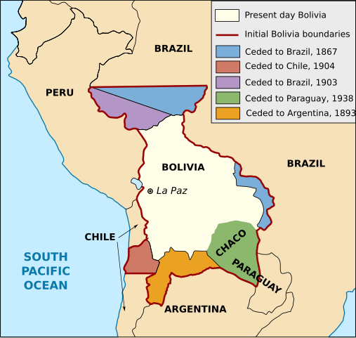
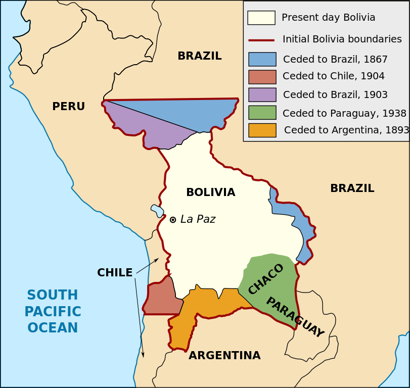
English: Territorial loss map of Bolivia |
| Tarix | (UTC) |
| Mənbə | |
| Müəllif |
|
| Digər versiyalar |
[]
Derivative works of this file: |


This work is in the public domain in the United States because it is a work prepared by an officer or employee of the United States Government as part of that person’s official duties under the terms of Title 17, Chapter 1, Section 105 of the US Code.
Note: This only applies to original works of the Federal Government and not to the work of any individual U.S. state, territory, commonwealth, county, municipality, or any other subdivision. This template also does not apply to postage stamp designs published by the United States Postal Service since 1978. (See § 313.6(C)(1) of Compendium of U.S. Copyright Office Practices). It also does not apply to certain US coins; see The US Mint Terms of Use.
|
 | |
| This file has been identified as being free of known restrictions under copyright law, including all related and neighboring rights. | ||
Faylın tarixçəsi
Faylın əvvəlki versiyasını görmək üçün gün/tarix bölməsindəki tarixlərə klikləyin.
| Tarix/Vaxt | Kiçik şəkil | Ölçülər | İstifadəçi | Şərh | |
|---|---|---|---|---|---|
| indiki | 16:19, 1 yanvar 2020 | | 375 × 355 (78 KB) | Janitoalevic | Added territory ceded to Argentina |
| 18:48, 12 dekabr 2013 |  | 375 × 355 (68 KB) | Pethrus | Fixed ocean name | |
| 16:07, 4 may 2010 |  | 375 × 355 (68 KB) | Naturals | The territory of Paraguay was reversed with the territory of Brazil | |
| 19:06, 3 may 2010 |  | 375 × 355 (69 KB) | Pethrus | Paraguay border fixed | |
| 19:02, 3 may 2010 |  | 375 × 355 (69 KB) | Pethrus | Fixed bugs | |
| 18:56, 3 may 2010 |  | 375 × 355 (79 KB) | Pethrus | Inkscape bugs fixed | |
| 18:53, 3 may 2010 |  | 375 × 355 (81 KB) | Pethrus | {{Information |Description={{en|Territorial loss map of Bolivia}} |Source=*File:Bolivia_territorial_loss_map_LOC.jpg |Date=2010-05-03 18:51 (UTC) |Author=*File:Bolivia_territorial_loss_map_LOC.jpg: Library of Congress Country Study on Bolivia |
Fayl keçidləri
Aşağıdakı 2 səhifə bu faylı istifadə edir:
Faylın qlobal istifadəsi
Bu fayl aşağıdakı vikilərdə istifadə olunur:
- ca.wikipedia.org layihəsində istifadəsi
- cs.wikipedia.org layihəsində istifadəsi
- da.wikipedia.org layihəsində istifadəsi
- de.wikipedia.org layihəsində istifadəsi
- en.wikipedia.org layihəsində istifadəsi
- eu.wikipedia.org layihəsində istifadəsi
- fi.wikipedia.org layihəsində istifadəsi
- fr.wikipedia.org layihəsində istifadəsi
- hi.wikipedia.org layihəsində istifadəsi
- hi.wiktionary.org layihəsində istifadəsi
- id.wikipedia.org layihəsində istifadəsi
- it.wikipedia.org layihəsində istifadəsi
- ja.wikipedia.org layihəsində istifadəsi
- ka.wikipedia.org layihəsində istifadəsi
- ko.wikipedia.org layihəsində istifadəsi
- lt.wikipedia.org layihəsində istifadəsi
- nl.wikipedia.org layihəsində istifadəsi
- pl.wikipedia.org layihəsində istifadəsi
- pt.wikipedia.org layihəsində istifadəsi
- sat.wikipedia.org layihəsində istifadəsi
- sd.wikipedia.org layihəsində istifadəsi
- sk.wikipedia.org layihəsində istifadəsi
- te.wikipedia.org layihəsində istifadəsi
- zh.wikipedia.org layihəsində istifadəsi