Fayl:South Africa 2011 population density map.svg
Naviqasiyaya keçin
Axtarışa keçin

Bu SVG-faylın PNG formatındakı bu görünüşünün ölçüsü: 684 × 599 piksel. Digər ölçülər: 274 × 240 piksel | 548 × 480 piksel | 876 × 768 piksel | 1.168 × 1.024 piksel | 2.337 × 2.048 piksel | 809 × 709 piksel.
Faylın orijinalı (SVG faylı, nominal olaraq 809 × 709 piksel, faylın ölçüsü: 1,93 MB)
| Bu fayl "Vikimedia Commons"dadır və digər layihələrdə istifadə edilə bilər. |
 |
Faylın təsvir səhifəsinə get |
Xülasə
| İzah |
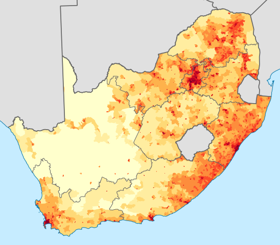
English: Population density map of South Africa, based on the 2011 census using ward-level data.
<1 inhabitant/km²
1–3 inhabitants/km²
3–10 inhabitants/km²
10–30 inhabitants/km²
30–100 inhabitants/km²
100–300 inhabitants/km²
300–1000 inhabitants/km²
1000–3000 inhabitants/km²
>3000 inhabitants/km²
Projection is Albers Equal-Area Conic, with standard parallels at 25.5° S and 31.5° S, and origin at 28.5° S 24.5° E.Deutsch: Bevölkerungsdichte Südafrikas im Jahr 2011:
<1 Einwohner/km²
1–3 Einwohner/km²
3–10 Einwohner/km²
10–30 Einwohner/km²
30–100 Einwohner/km²
100–300 Einwohner/km²
300–1000 Einwohner/km²
1000–3000 Einwohner/km²
>3000 Einwohner/km² |
| Tarix | |
| Mənbə | Statistics South Africa's Census 2011 is the source of the basic population data. The map results from my own processing of the data. For ward boundaries see File:South Africa electoral wards 2011 blank.svg. |
| Müəllif | Htonl |
| Digər versiyalar |
South Africa 2011 population density map (hex cells).svg: .svg) |
Lisenziya
The following license applies to the population data on which the map is based:

|
The copyright holder of this file, Stats SA, allows anyone to use it for any purpose, provided that the copyright holder is properly attributed. Redistribution, derivative work, commercial use, and all other use is permitted. |
İstinad:
"the user acknowledges Stats SA as the source of the basic data wherever they process, apply, utilise, publish or distribute the data, and also that they specify that the relevant application and analysis (where applicable) result from their own processing of the data" [1]
|
The following tag applies to the map itself:
| Mən, bu əsərin müəllif hüquqlarının sahibi kimi, əsəri ictimai mülkiyyətə verirəm. Bu icazə bütün dünyada qüvvədədir. In some countries this may not be legally possible; if so: Bunun qanunla mümkün olmadığı hallarda: İstənilən şəxsə, istənilən məqsəd üçün, qanunlar tərəfindən qadağan edilməyincə, heç bir şərt qoymadan bu işdən istifadə haqqını bağışlayıram. |
Faylın tarixçəsi
Faylın əvvəlki versiyasını görmək üçün gün/tarix bölməsindəki tarixlərə klikləyin.
| Tarix/Vaxt | Kiçik şəkil | Ölçülər | İstifadəçi | Şərh | |
|---|---|---|---|---|---|
| indiki | 23:36, 14 noyabr 2012 | | 809 × 709 (1,93 MB) | Htonl | fix KZN coast error |
| 21:57, 14 noyabr 2012 |  | 809 × 709 (1,93 MB) | Htonl | == {{int:filedesc}} == {{Information |Description={{en|1=Population density map of South Africa, based on the 2011 census using ward-level data. {{legend|#ffffcc|<1 inhabitant/km²}} {{legend|#ffeda0|1–3 inhabitants/km²}} {{legend|#fed976|3–10 ... |
Fayl keçidləri
Aşağıdakı səhifə bu faylı istifadə edir:
Faylın qlobal istifadəsi
Bu fayl aşağıdakı vikilərdə istifadə olunur:
- af.wikipedia.org layihəsində istifadəsi
- azb.wikipedia.org layihəsində istifadəsi
- ca.wikipedia.org layihəsində istifadəsi
- cs.wikipedia.org layihəsində istifadəsi
- de.wikipedia.org layihəsində istifadəsi
- el.wikipedia.org layihəsində istifadəsi
- en.wikipedia.org layihəsində istifadəsi
- es.wikipedia.org layihəsində istifadəsi
- et.wikipedia.org layihəsində istifadəsi
- fr.wikipedia.org layihəsində istifadəsi
- gl.wikipedia.org layihəsində istifadəsi
- he.wikipedia.org layihəsində istifadəsi
- hu.wikipedia.org layihəsində istifadəsi
- hy.wikipedia.org layihəsində istifadəsi
- ja.wikipedia.org layihəsində istifadəsi
- ka.wikipedia.org layihəsində istifadəsi
- ko.wikipedia.org layihəsində istifadəsi
- la.wikipedia.org layihəsində istifadəsi
- lt.wikipedia.org layihəsində istifadəsi
- ml.wikipedia.org layihəsində istifadəsi
- nl.wikipedia.org layihəsində istifadəsi
- no.wikipedia.org layihəsində istifadəsi
- pt.wikipedia.org layihəsində istifadəsi
- ro.wikipedia.org layihəsində istifadəsi
- ru.wikipedia.org layihəsində istifadəsi
- sr.wikipedia.org layihəsində istifadəsi
- sv.wikipedia.org layihəsində istifadəsi
- te.wikipedia.org layihəsində istifadəsi
- tg.wikipedia.org layihəsində istifadəsi
- tr.wikipedia.org layihəsində istifadəsi
- uk.wikipedia.org layihəsində istifadəsi
- zh.wikipedia.org layihəsində istifadəsi