Fayl:Wfm area 51 landsat geocover 2000.jpg
Naviqasiyaya keçin
Axtarışa keçin
Sınaq göstərişi ölçüsü: 475 × 599 piksel. Digər ölçülər: 190 × 240 piksel | 381 × 480 piksel | 752 × 948 piksel.
Faylın orijinalı (752 × 948 piksel, fayl həcmi: 383 KB, MIME növü: image/jpeg)
| Bu fayl "Vikimedia Commons"dadır və digər layihələrdə istifadə edilə bilər. |
 |
Faylın təsvir səhifəsinə get |
| İzah |
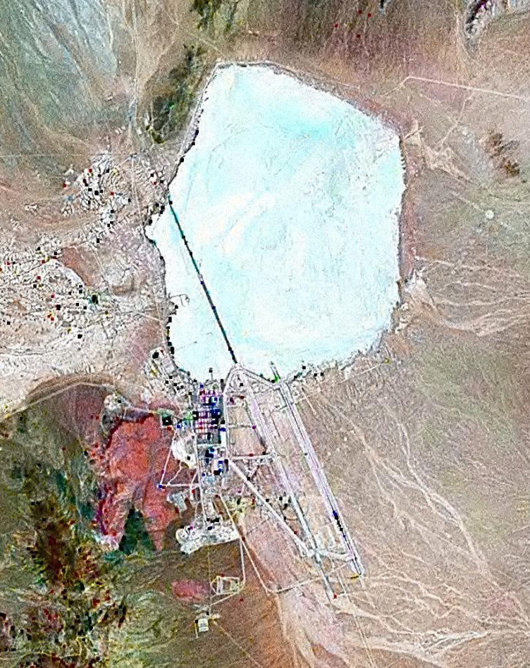
English: Landsat GeoCover 2000 pseudocolour imagery of Area 51 at Groom Lake, Nevada Test and Training Range, Nevada, USA
|
||||
| Tarix | circa 2000 | ||||
| Mənbə | NASA Landsat | ||||
| Müəllif | NASA | ||||
| İcazə (Faylın təkrar istifadəsi) |
|

Faylın tarixçəsi
Faylın əvvəlki versiyasını görmək üçün gün/tarix bölməsindəki tarixlərə klikləyin.
| Tarix/Vaxt | Kiçik şəkil | Ölçülər | İstifadəçi | Şərh | |
|---|---|---|---|---|---|
| indiki | 12:42, 18 fevral 2010 | | 752 × 948 (383 KB) | Finlay McWalter | rv, that's not a landsat image; it looks very much like a copyright GeoEye/Google Earth image, which is inelligible for use on Commons. If you diagree, upload the image under another name, don't contaminate this one with false information |
| 11:05, 7 fevral 2010 |  | 456 × 617 (45 KB) | Vajotwo | Best quality | |
| 12:51, 16 iyul 2006 |  | 752 × 948 (383 KB) | Finlay McWalter | {{Information |Description=Landsat geocover 2000 pseudocolour imagery of Area 51 at Groom Lake, Nevada, USA |Source=NASA Landsat |Date=around 2000 |Author=NASA |Permission= {{PD-WorldWind}} |other_versions= }} Category:Area 51 |
Fayl keçidləri
Aşağıdakı 2 səhifə bu faylı istifadə edir:
Faylın qlobal istifadəsi
Bu fayl aşağıdakı vikilərdə istifadə olunur:
- ar.wikipedia.org layihəsində istifadəsi
- be.wikipedia.org layihəsində istifadəsi
- bg.wikipedia.org layihəsində istifadəsi
- bn.wikipedia.org layihəsində istifadəsi
- cs.wikipedia.org layihəsində istifadəsi
- cy.wikipedia.org layihəsində istifadəsi
- el.wikipedia.org layihəsində istifadəsi
- en.wikipedia.org layihəsində istifadəsi
- es.wikipedia.org layihəsində istifadəsi
- fi.wikipedia.org layihəsində istifadəsi
- fr.wikipedia.org layihəsində istifadəsi
- Zone 51
- Wikipédia:Le Bistro/14 février 2009
- Area 51 (jeu vidéo, 2005)
- Wikipédia:Wikimag/2019/28/Rapport de trafic
- Wikipédia:Wikimag/2019/29/Rapport de trafic
- Wikipédia:Wikimag/2019/29
- Wikipédia:Wikimag/2019/30/Rapport de trafic
- Wikipédia:Wikimag/2019/31/Rapport de trafic
- Wikipédia:Wikimag/2019/38
- Wikipédia:Wikimag/2019/39/Rapport de trafic
- gu.wikipedia.org layihəsində istifadəsi
- he.wikipedia.org layihəsində istifadəsi
- hi.wikipedia.org layihəsində istifadəsi
- hr.wikipedia.org layihəsində istifadəsi
- hu.wikipedia.org layihəsində istifadəsi
- hy.wikipedia.org layihəsində istifadəsi
- id.wikipedia.org layihəsində istifadəsi
- it.wikipedia.org layihəsində istifadəsi
- kk.wikipedia.org layihəsində istifadəsi
- kn.wikipedia.org layihəsində istifadəsi
- mk.wikipedia.org layihəsində istifadəsi
- my.wikipedia.org layihəsində istifadəsi
- pnb.wikipedia.org layihəsində istifadəsi
- ro.wikipedia.org layihəsində istifadəsi
- ru.wikipedia.org layihəsində istifadəsi
- sh.wikipedia.org layihəsində istifadəsi
- si.wikipedia.org layihəsində istifadəsi
- sk.wikipedia.org layihəsində istifadəsi
- sl.wikipedia.org layihəsində istifadəsi
Bu faylın qlobal istifadəsinə baxın.