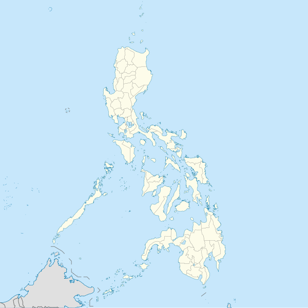
Fayl:Philippines location map (square).svg

Vikipediya, azad ensiklopediya
Naviqasiyaya keç Axtarışa keç

Faylın orijinalı(SVG faylı, nominal olaraq 1.332 × 1.332 piksel, faylın ölçüsü: 1,49 MB)

Bu fayl "Vikimedia Commons"dadır
və digər layihələrdə istifadə edilə bilər.
təsvir səhifəsi
təsvir səhifəsi
Faylın təsvir səhifəsinə get

Xülasə

https://commons.m.wikimedia.org/wiki/File:VisualEditor_tables_type_inside_a_cell.png

İzah
English: Located in Burgos, Ilocos Norte
This is a photo of a cultural heritage property in the Philippines with ID
PH-01-0006
Tarix
Mənbə Öz işi
Müəllif

[[User:Lumaktaw sa pangunahing content Account Kahapon, 12:53 AMBago

Bagong pag-sign in sa Galaxy A03 larendovaldez0@gmail.com Nasa panganib ang iyong account kung hindi ikaw ito

Galaxy A03 Pilipinas Ang teleponong ito Pamilyar ba sa iyo ang aktibidad na ito? Hindi, i-secure ang account Oo, ako iyon |

Map data ©2024 5 km Devices La Dez 11th Apr 8:16 PM 4HMH+8X San Nicolas, Ilocos Norte, Philippines

]]

Wikimedia Commons

Search File:Cape Bojeador Light House.JPG Language Watch Edit File File history File usage on Commons File usage on other wikis Metadata File:Cape Bojeador Light House.JPG Size of this preview: 800 × 536 pixels. Other resolutions: 320 × 214 pixels | 640 × 429 pixels | 1,024 × 686 pixels | 1,280 × 857 pixels | 2,890 × 1,935 pixels. Original file ‎(2,890 × 1,935 pixels, file size: 5.43 MB, MIME type: image/jpeg); ZoomViewer

File information Structured data Structured data labels link to their respective Wikidata pages and will open in a new window. Items portrayed in this file depicts Search to add items

Custom value Cape Bojeador Lighthouse Mark as prominent creator Search to add items

Custom value some value Mark as prominent Qualifiers object has role photographer

Custom value URL https://commons.wikimedia.org/wiki/User:File:VisualEditor_tables_type_inside_a_cell.png author name string File:VisualEditor_tables_type_inside_a_cell.png Wikimedia username https://commons.m.wikimedia.org/wiki/File:Cape_Bojeador_Light_House.JPG#/editor/1 References

copyright status copyrighted Mark as prominent copyright license Creative Commons Attribution-ShareAlike 3.0 Unported Mark as prominent source of file original creation by uploader Mark as prominent inception 2 April 2010 Mark as prominent captured with Nikon D60 Mark as prominent participant in Wiki Loves Monuments 2012 Mark as prominent MIME type image/jpeg Mark as prominent checksum

İzah Wikipedia logo 2.0
Tarix n/a
Mənbə Wikimedia Foundation
Müəllif https://commons.m.wikimedia.org/wiki/File:VisualEditor_tables_type_inside_a_cell.png
İcazə
(Faylın təkrar istifadəsi)
Trademarked
™ Wikimedia Foundation, Inc.
This file is (or includes) one or more of the official logos or designs used by the Wikimedia Foundation or by one of its projects. Use of the Wikimedia logos and trademarks is subject to the Wikimedia trademark policy and visual identity guidelines, and may require permission.

This tag does not indicate the copyright status of the attached work. A normal copyright tag is still required. See Commons:Licensing. 

w:az:Creative Commons
istinad bənzər paylaşma
Bu fayl Creative Commons Attribution-Share Alike 3.0 Unported lisenziyası altında yayımlanır.
Azadsınız:
  • paylaşmaq – əsəri köçürmək, paylamaq və ötürmək üçün
  • remiks etmək – əsəri adaptasiya etmək
Aşağıdakı şərtlərə riayət etməklə:
  • istinad – Müvafiq kredit verməlisiniz, lisenziyaya bir keçid verməlisiniz və dəyişikliklərin olub olmadığını bildirməlisiniz. Bunu hər hansı bir ağlabatan şəkildə edə bilərsiniz, ancaq lisenziyalaşdırıcının sizi və ya istifadənizi təsdiqləməsini təklif edən bir şəkildə deyil.
  • bənzər paylaşma – Əsəri remix edirsinizsə, dəyişdirirsinizsə və ya üzərində iş aparırsınızsa, öz töhfələrinizi orijinalda olduğu kimi eyni və ya uyğun lisenziya altında yayımlamalısınız.

Mark as prominent determination method

SHA-1 data size 5,694,181 byte Mark as prominent height 1,935 pixel Mark as prominent width 2,890 pixel Mark as prominent Wikimedia Commons Files are available under licenses specified on their description page. All structured data from the file namespace is available under the Creative Commons CC0 License; all unstructured text is available under the Creative Commons Attribution-ShareAlike License; additional terms may apply. By using this site, you agree to the Terms of Use and the Privacy Policy. Privacy policy Terms of UseDesktop You are not logged in and your IP address will be publicly visible if you make any edits. Logging in or creating an account will conceal your IP address and provide you with many other benefits. Please do not save test edits. If you want to experiment, please use the Sandbox.

==Xülasə==
İzah
English: Location map of the Philippines

Equirectangular projection based on the parallel of 10°43' N

  • N: 21.2° N
  • S: 4.3° N
  • W: 114.0° E
  • E: 131.2° E
Tarix
Mənbə

Öz işi

Author=WikiRoulete
Müəllif Hellerick Edit this at Structured Data on Commons

|other fields=SVG genesis

InfoField
 
The SVG code is valid.
 
This map was created with Inkscape.

}}This template has no documented parameters and may be intended for use without them.

Lisenziya

I, the copyright holder of this work, hereby publish it under the following license:
w:az:Creative Commons
istinad bənzər paylaşma
Bu fayl Creative Commons Attribution-Share Alike 3.0 Unported lisenziyası altında yayımlanır.
Azadsınız:
  • paylaşmaq – əsəri köçürmək, paylamaq və ötürmək üçün
  • remiks etmək – əsəri adaptasiya etmək
Aşağıdakı şərtlərə riayət etməklə:
  • istinad – Müvafiq kredit verməlisiniz, lisenziyaya bir keçid verməlisiniz və dəyişikliklərin olub olmadığını bildirməlisiniz. Bunu hər hansı bir ağlabatan şəkildə edə bilərsiniz, ancaq lisenziyalaşdırıcının sizi və ya istifadənizi təsdiqləməsini təklif edən bir şəkildə deyil.
  • bənzər paylaşma – Əsəri remix edirsinizsə, dəyişdirirsinizsə və ya üzərində iş aparırsınızsa, öz töhfələrinizi orijinalda olduğu kimi eyni və ya uyğun lisenziya altında yayımlamalısınız.

Captions

Add a one-line explanation of what this file represents
Map of the Philippines Islands (P.I.)

Items portrayed in this file

təsvir edir

copyrighted ingilis

17 iyun 2013

media type ingilis

image/svg+xml

Faylın tarixçəsi

Faylın əvvəlki versiyasını görmək üçün gün/tarix bölməsindəki tarixlərə klikləyin.

(ən yeni | ən əvvəlki) Göstər (10 daha yeni) () (10 | 20 | 50 | 100 | 250 | 500).
Tarix/VaxtKiçik şəkilÖlçülərİstifadəçiŞərh
indiki10:17, 19 avqust 202110:17, 19 avqust 2021 tarixindəki versiyanın kiçildilmiş görüntüsü1.332 × 1.332 (1,49 MB)AichiWikiFixerUpdated boundaries
07:53, 18 iyun 202107:53, 18 iyun 2021 tarixindəki versiyanın kiçildilmiş görüntüsü1.332 × 1.332 (2,24 MB)AichiWikiFixerMap update.
03:55, 18 iyun 202103:55, 18 iyun 2021 tarixindəki versiyanın kiçildilmiş görüntüsü1.332 × 1.332 (2,23 MB)AichiWikiFixerSmall changes.
03:49, 18 iyun 202103:49, 18 iyun 2021 tarixindəki versiyanın kiçildilmiş görüntüsü1.332 × 1.332 (2,23 MB)AichiWikiFixerExternal changes for boundaries and coastlines.
13:11, 17 iyun 202113:11, 17 iyun 2021 tarixindəki versiyanın kiçildilmiş görüntüsü1.332 × 1.332 (2,23 MB)AichiWikiFixerAdditional islands, lakes, and updated coastlines.
10:34, 17 iyun 202110:34, 17 iyun 2021 tarixindəki versiyanın kiçildilmiş görüntüsü1.332 × 1.332 (2,23 MB)AichiWikiFixerUpdate boundaries.
02:04, 25 may 202102:04, 25 may 2021 tarixindəki versiyanın kiçildilmiş görüntüsü1.332 × 1.332 (2,22 MB)HueMan1Reverted to version as of 07:24, 7 September 2020 (UTC)
07:11, 17 may 202107:11, 17 may 2021 tarixindəki versiyanın kiçildilmiş görüntüsü1.332 × 1.332 (3,72 MB)PetrioloReverted to version as of 05:36, 3 May 2021 (UTC) The new administrative borders are based from the Philippine government websites (https://www.geoportal.gov.ph/; http://noah.up.edu.ph/), and is deemed accurate. These new files have reliable sources and there's no "beauty" in it if it is inaccurate in the first place.
14:00, 16 may 202114:00, 16 may 2021 tarixindəki versiyanın kiçildilmiş görüntüsü1.332 × 1.332 (2,22 MB)AichiWikiFixerReverted to version as of 07:24, 7 September 2020 (UTC) (Borders seen as ugly)
05:36, 3 may 202105:36, 3 may 2021 tarixindəki versiyanın kiçildilmiş görüntüsü1.332 × 1.332 (3,72 MB)Petrioloupdated with NAMRIA borders
(ən yeni | ən əvvəlki) Göstər (10 daha yeni) () (10 | 20 | 50 | 100 | 250 | 500).

Bu faylı istifadə edən səhifə yoxdur.

Faylın qlobal istifadəsi

Metaməlumatlar