Fayl:CzechRepublic-geographic map-en.svg

Vikipediya, azad ensiklopediya
Naviqasiyaya keç Axtarışa keç

Faylın orijinalı(SVG faylı, nominal olaraq 1.949 × 1.200 piksel, faylın ölçüsü: 14,56 MB)

Bu fayl "Vikimedia Commons"dadır
və digər layihələrdə istifadə edilə bilər.
təsvir səhifəsi
təsvir səhifəsi
Faylın təsvir səhifəsinə get

Xülasə

Description
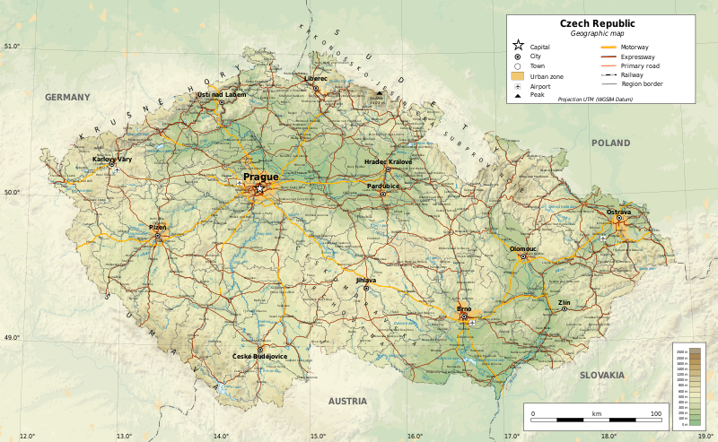
English: Geographic map of the Czech Republic. Geographic limits of the map:
Українська: Топографічна карта Чехії.
  • S: 48.3° N
  • N: 51.3° N
  • W: 11.8° E
  • E: 19.2° E
Projection: UTM
Tarix
Mənbə

Öz işi

  • Sources of data:
    • Topography: NASA SRTM3 v2;
    • Urbanised areas: Natural Earth;
    • Other data: © OpenStreetMap contributors
  • Tool:
    • The map is created with Octave scripts developed by Ikonact
Yaradıcı
İcazə
(Faylın təkrar istifadəsi)
Any use of this map is subject of the license(s) stated below with the condition that you credit (Wikimedia Commons user: Ikonact) as the author . A message with a reply address would also be greatly appreciated.
Georeferencing Georeference the map in Wikimaps Warper If inappropriate please set warp_status = skip to hide.
Digər versiyalar

Featured görüntü

Vikianbar

This is a featured picture on Wikimedia Commons (Featured pictures) and is considered one of the finest images.

If you have an image of similar quality that can be published under a suitable copyright license, be sure to upload it, tag it, and nominate it.


Translate this file This SVG file contains embedded text that can be translated into your language, using any capable SVG editor, text editor or the SVG Translate tool. For more information see: About translating SVG files.
 
The SVG code is valid.
 
This vector image was created with Inkscape, and then manually edited
.

Lisenziya

This work contains information from OpenStreetMap, which is made available under the Open Database License (ODbL).

The ODbL does not require any particular license for maps produced from ODbL data. Prior to 1 August 2020, map tiles produced by the OpenStreetMap Foundation were licensed under the CC-BY-SA-2.0 license. Maps produced by other people may be subject to other licences.

I, the copyright holder of this work, hereby publish it under the following license:
w:az:Creative Commons
istinad bənzər paylaşma
This file is licensed under the Creative Commons Attribution-Share Alike 4.0 International license.
Azadsınız:
  • paylaşmaq – əsəri köçürmək, paylamaq və ötürmək üçün
  • remiks etmək – əsəri adaptasiya etmək
Aşağıdakı şərtlərə riayət etməklə:
  • istinad – Müvafiq kredit verməlisiniz, lisenziyaya bir keçid verməlisiniz və dəyişikliklərin olub olmadığını bildirməlisiniz. Bunu hər hansı bir ağlabatan şəkildə edə bilərsiniz, ancaq lisenziyalaşdırıcının sizi və ya istifadənizi təsdiqləməsini təklif edən bir şəkildə deyil.
  • bənzər paylaşma – Əsəri remix edirsinizsə, dəyişdirirsinizsə və ya üzərində iş aparırsınızsa, öz töhfələrinizi orijinalda olduğu kimi eyni və ya uyğun lisenziya altında yayımlamalısınız.

Captions

Add a one-line explanation of what this file represents
Geographical map of the Czech Republic

Items portrayed in this file

təsvir edir

copyrighted ingilis

11 noyabr 2017

media type ingilis

image/svg+xml

checksum ingilis

c147df8778a4f5dbbc21c9d475cf7f1e58102c79

data size ingilis

15.264.412 Bayt

1.949 piksel

Faylın tarixçəsi

Faylın əvvəlki versiyasını görmək üçün gün/tarix bölməsindəki tarixlərə klikləyin.

Tarix/VaxtKiçik şəkilÖlçülərİstifadəçiŞərh
indiki23:02, 20 dekabr 201723:02, 20 dekabr 2017 tarixindəki versiyanın kiçildilmiş görüntüsü1.949 × 1.200 (14,56 MB)Ikonactrailways cleaned a bit, town names replaced, legend completed
11:36, 14 dekabr 201711:36, 14 dekabr 2017 tarixindəki versiyanın kiçildilmiş görüntüsü1.949 × 1.200 (14,99 MB)Ikonactfont corrected
20:20, 29 noyabr 201720:20, 29 noyabr 2017 tarixindəki versiyanın kiçildilmiş görüntüsü1.949 × 1.200 (14,99 MB)Ikonactgeography
20:03, 21 noyabr 201720:03, 21 noyabr 2017 tarixindəki versiyanın kiçildilmiş görüntüsü1.949 × 1.200 (14,98 MB)Ikonactfinal
21:14, 19 noyabr 201721:14, 19 noyabr 2017 tarixindəki versiyanın kiçildilmiş görüntüsü1.949 × 1.200 (14,96 MB)Ikonact+ railways
23:07, 15 noyabr 201723:07, 15 noyabr 2017 tarixindəki versiyanın kiçildilmiş görüntüsü1.949 × 1.200 (15,31 MB)Ikonact+ reservoir names, admin borders
22:03, 14 noyabr 201722:03, 14 noyabr 2017 tarixindəki versiyanın kiçildilmiş görüntüsü1.949 × 1.200 (15,22 MB)Ikonact+ river names, cities outside of CZ deleted
22:22, 13 noyabr 201722:22, 13 noyabr 2017 tarixindəki versiyanın kiçildilmiş görüntüsü1.949 × 1.200 (15,2 MB)Ikonactfont size
20:21, 11 noyabr 201720:21, 11 noyabr 2017 tarixindəki versiyanın kiçildilmiş görüntüsü1.949 × 1.200 (15,22 MB)Ikonact=={{int:filedesc}}== {{Information |description={{en|1=Geographic map of Czech Republic. Geographic limits of the map:}} *S: 48.3° N *N: 51.3° N *W: 11.8° W *E: 19.2° W Projection: UTM |date=2017-11-11 |source={{own}} *Source...

Aşağıdakı səhifə bu faylı istifadə edir:

Faylın qlobal istifadəsi

Bu fayl aşağıdakı vikilərdə istifadə olunur:

Metaməlumatlar