Fayl:Carte Guerre de Sept Ans Europe.PNG
Faylın orijinalı (884 × 643 piksel, fayl həcmi: 77 KB, MIME növü: image/png)
| Bu fayl "Vikimedia Commons"dadır və digər layihələrdə istifadə edilə bilər. |
 |
Faylın təsvir səhifəsinə get |
Incorrect Information
- After the Russian-Swedisch war of 1741–1743 Finnland was russian in the East, up to the river Kymijoki, and Swedish in the western part. --El bes (talk) 21:02, 10 August 2008 (UTC)
An even bigger error here is that the UK, formed in 1707, is listed as England. Also, Ireland didn't join the Union until 1801, and at the time was still a kingdom in its own right.
Poland should be shown as the Polish-Lithuanian Commonwealth.
Austro-Ottoman borders shown here are actually from 1718-1739 period, between Treaty of Požarevac and Treaty of Belgrade

|
This historical map image could be re-created using vector graphics as an SVG file. This has several advantages; see Commons:Media for cleanup for more information. If an SVG form of this image is available, please upload it and afterwards replace this template with
{{vector version available|new image name}}.
It is recommended to name the SVG file “Carte Guerre de Sept Ans Europe.svg”—then the template Vector version available (or Vva) does not need the new image name parameter. |
Xülasə
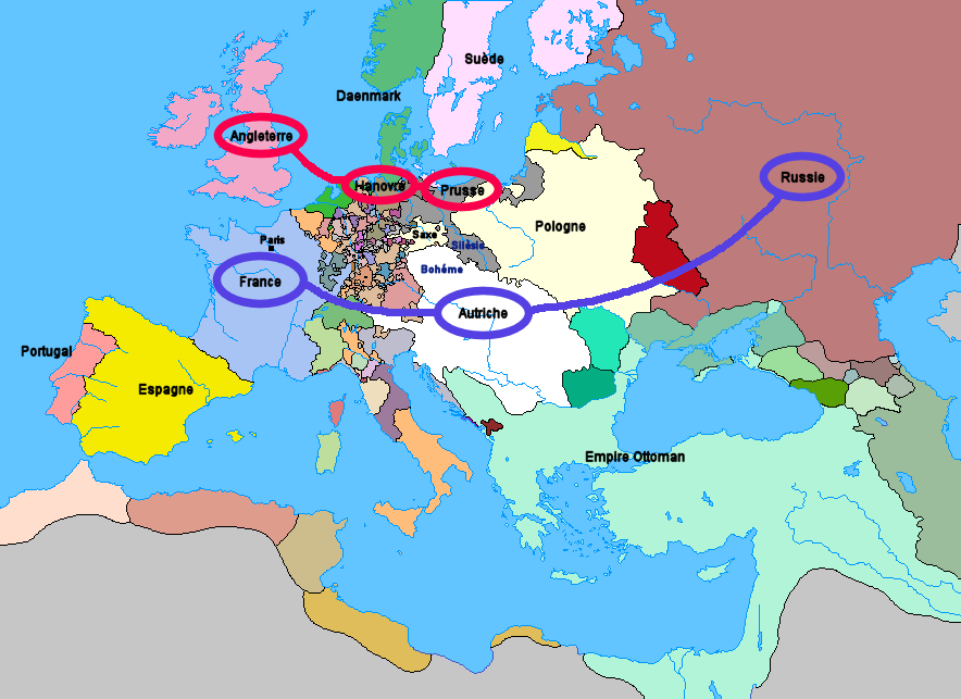
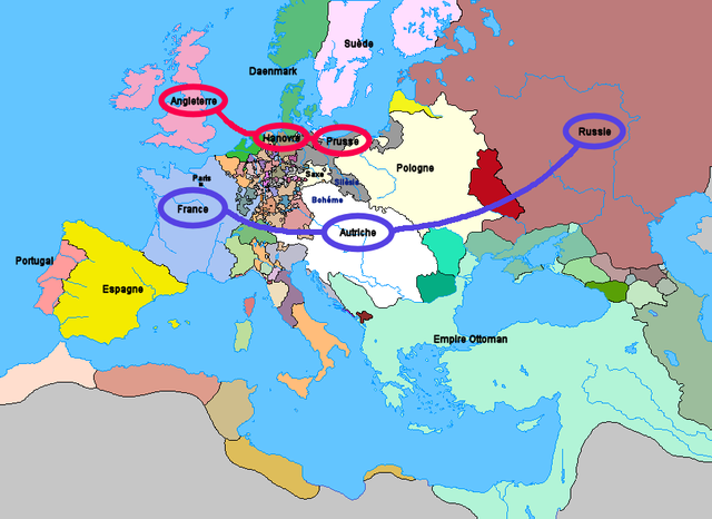
Carte de l'Europe et des alliances à la veille de la guerre de Sept Ans (1757)
Lisenziya
Upload: Wordelle
| Mən, bu əsərin müəllif hüquqlarının sahibi kimi, əsəri ictimai mülkiyyətə verirəm. Bu icazə bütün dünyada qüvvədədir. In some countries this may not be legally possible; if so: Bunun qanunla mümkün olmadığı hallarda: İstənilən şəxsə, istənilən məqsəd üçün, qanunlar tərəfindən qadağan edilməyincə, heç bir şərt qoymadan bu işdən istifadə haqqını bağışlayıram. |
No machine-readable source provided. Own work assumed (based on copyright claims).
Faylın tarixçəsi
Faylın əvvəlki versiyasını görmək üçün gün/tarix bölməsindəki tarixlərə klikləyin.
| Tarix/Vaxt | Kiçik şəkil | Ölçülər | İstifadəçi | Şərh | |
|---|---|---|---|---|---|
| indiki | 21:25, 1 yanvar 2012 | | 884 × 643 (77 KB) | Artemis Dread | Republic of Ragusa |
| 22:19, 24 dekabr 2011 |  | 884 × 643 (77 KB) | Artemis Dread | Prince-Bishopric of Montenegro | |
| 10:58, 18 sentyabr 2011 |  | 884 × 643 (77 KB) | Artemis Dread | Kingdom of Imereti and Kingdom of Kartli-Kakheti, minor changes | |
| 14:31, 17 sentyabr 2011 |  | 884 × 643 (76 KB) | Artemis Dread | Finland | |
| 13:15, 17 sentyabr 2011 |  | 884 × 643 (76 KB) | Artemis Dread | minor changes | |
| 12:17, 17 sentyabr 2011 |  | 884 × 643 (76 KB) | Artemis Dread | Duchy of Courland and Semigallia | |
| 11:13, 17 sentyabr 2011 |  | 884 × 643 (76 KB) | Artemis Dread | Cossack Hetmanate | |
| 10:36, 17 sentyabr 2011 |  | 884 × 643 (76 KB) | Artemis Dread | vassals of the Ottoman Empire | |
| 09:30, 18 oktyabr 2006 |  | 884 × 643 (72 KB) | Wordelle | Carte de l'Europe et des alliances à la veille de la guerre de Sept Ans (1757) |
Fayl keçidləri
Aşağıdakı səhifə bu faylı istifadə edir:
Faylın qlobal istifadəsi
Bu fayl aşağıdakı vikilərdə istifadə olunur:
- af.wikipedia.org layihəsində istifadəsi
- ar.wikipedia.org layihəsində istifadəsi
- bg.wikipedia.org layihəsində istifadəsi
- br.wikipedia.org layihəsində istifadəsi
- ca.wikipedia.org layihəsində istifadəsi
- cs.wikipedia.org layihəsində istifadəsi
- de.wikipedia.org layihəsində istifadəsi
- el.wikipedia.org layihəsində istifadəsi
- en.wikipedia.org layihəsində istifadəsi
- Military history of the Russian Empire
- Diplomatic Revolution
- Portal:Russia/Selected anniversaries
- Portal:Russia/Selected anniversaries/May
- Stately quadrille
- Wenzel Anton, Prince of Kaunitz-Rietberg
- History of the foreign relations of the United Kingdom
- User:Rjensen/International relations 1648-1814
- User:Falcaorib
- et.wikipedia.org layihəsində istifadəsi
- eu.wikipedia.org layihəsində istifadəsi
- fr.wikipedia.org layihəsində istifadəsi
- fr.wikiversity.org layihəsində istifadəsi
- he.wikipedia.org layihəsində istifadəsi
- hu.wikipedia.org layihəsində istifadəsi
- id.wikipedia.org layihəsində istifadəsi
- it.wikipedia.org layihəsində istifadəsi
- ja.wikipedia.org layihəsində istifadəsi
- la.wikipedia.org layihəsində istifadəsi
- lv.wikipedia.org layihəsində istifadəsi
- ms.wikipedia.org layihəsində istifadəsi
- nl.wikipedia.org layihəsində istifadəsi
- nn.wikipedia.org layihəsində istifadəsi
- no.wikipedia.org layihəsində istifadəsi
- ro.wikipedia.org layihəsində istifadəsi
- ru.wikipedia.org layihəsində istifadəsi
- sh.wikipedia.org layihəsində istifadəsi
- sr.wikipedia.org layihəsində istifadəsi
- sv.wikipedia.org layihəsində istifadəsi
- sw.wikipedia.org layihəsində istifadəsi
- th.wikipedia.org layihəsində istifadəsi
- tr.wikipedia.org layihəsində istifadəsi
- uk.wikipedia.org layihəsində istifadəsi
Bu faylın qlobal istifadəsinə baxın.