Fayl:LocatieRotterdam-2010.png
Naviqasiyaya keç
Axtarışa keç
Daha yüksək versiyası yoxdur.
LocatieRotterdam-2010.png (280 × 130 piksel, fayl həcmi: 6 KB, MIME növü: image/png)
| Bu fayl "Vikimedia Commons"dadır və digər layihələrdə istifadə edilə bilər. |
 |
Faylın təsvir səhifəsinə get |

|
This locator map image could be re-created using vector graphics as an SVG file. This has several advantages; see Commons:Media for cleanup for more information. If an SVG form of this image is available, please upload it and afterwards replace this template with
{{vector version available|new image name}}.
It is recommended to name the SVG file “LocatieRotterdam-2010.svg”—then the template Vector version available (or Vva) does not need the new image name parameter. |
Xülasə
| İzah |
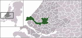
English: Map of Rotterdam: update for 2010 boundary change (addition of Rozenburg) |
| Tarix | (UTC) |
| Mənbə | |
| Müəllif |
|
Lisenziya
| Mən, bu əsərin müəllif hüquqlarının sahibi kimi, əsəri ictimai mülkiyyətə verirəm. Bu icazə bütün dünyada qüvvədədir. In some countries this may not be legally possible; if so: Bunun qanunla mümkün olmadığı hallarda: İstənilən şəxsə, istənilən məqsəd üçün, qanunlar tərəfindən qadağan edilməyincə, heç bir şərt qoymadan bu işdən istifadə haqqını bağışlayıram. |
Orijinal yükləmə gündəliyi
This image is a derivative work of the following images:
- File:LocatieRotterdam.png licensed with PD-user
- 2005-06-19T00:24:29Z Andrew pmk 280x130 (5877 Bytes) pngcrush
- 2004-09-10T09:43:47Z Quistnix 280x130 (10042 Bytes) Location of Rotterdam in the Netherlands - by [[:nl:Gebruiker:Mtcv]]
Faylın tarixçəsi
Faylın əvvəlki versiyasını görmək üçün gün/tarix bölməsindəki tarixlərə klikləyin.
| Tarix/Vaxt | Kiçik şəkil | Ölçülər | İstifadəçi | Şərh | |
|---|---|---|---|---|---|
| indiki | 23:16, 22 aprel 2010 | | 280 × 130 (6 KB) | P199 | {{Information |Description={{en|Map of Rotterdam: update for 2010 boundary change (addition of Rozenburg)}} |Source=*File:LocatieRotterdam.png |Date=2010-04-22 23:13 (UTC) |Author=*File:LocatieRotterdam.png: '''Mtcv''' *derivativ |
Fayl keçidləri
Bu faylı istifadə edən səhifə yoxdur.
Faylın qlobal istifadəsi
Bu fayl aşağıdakı vikilərdə istifadə olunur:
- af.wikipedia.org layihəsində istifadəsi
- als.wikipedia.org layihəsində istifadəsi
- arz.wikipedia.org layihəsində istifadəsi
- ban.wikipedia.org layihəsində istifadəsi
- bn.wikipedia.org layihəsində istifadəsi
- de.wikipedia.org layihəsində istifadəsi
- en.wikipedia.org layihəsində istifadəsi
- fj.wikipedia.org layihəsində istifadəsi
- fr.wikipedia.org layihəsində istifadəsi
- id.wikipedia.org layihəsində istifadəsi
- is.wikipedia.org layihəsində istifadəsi
- li.wikipedia.org layihəsində istifadəsi
- mai.wikipedia.org layihəsində istifadəsi
- mk.wikipedia.org layihəsində istifadəsi
- mn.wikipedia.org layihəsində istifadəsi
- nl.wikipedia.org layihəsində istifadəsi
- sco.wikipedia.org layihəsində istifadəsi
- sq.wikipedia.org layihəsində istifadəsi
- th.wikipedia.org layihəsində istifadəsi
- tr.wikipedia.org layihəsində istifadəsi
- uk.wikipedia.org layihəsində istifadəsi
- ur.wikipedia.org layihəsində istifadəsi
- zh-min-nan.wikipedia.org layihəsində istifadəsi
- zh.wikipedia.org layihəsində istifadəsi
- zu.wikipedia.org layihəsində istifadəsi