Fayl:Northern-Sentinel-Map.jpg
Naviqasiyaya keç
Axtarışa keç
Sınaq göstərişi ölçüsü: 628 × 600 piksel. Digər ölçülər: 251 × 240 piksel | 502 × 480 piksel | 804 × 768 piksel | 1.072 × 1.024 piksel | 2.144 × 2.048 piksel | 3.222 × 3.078 piksel.
Faylın orijinalı (3.222 × 3.078 piksel, fayl həcmi: 5,3 MB, MIME növü: image/jpeg)
| Bu fayl "Vikimedia Commons"dadır və digər layihələrdə istifadə edilə bilər. |
 |
Faylın təsvir səhifəsinə get |
Xülasə
| İzah |
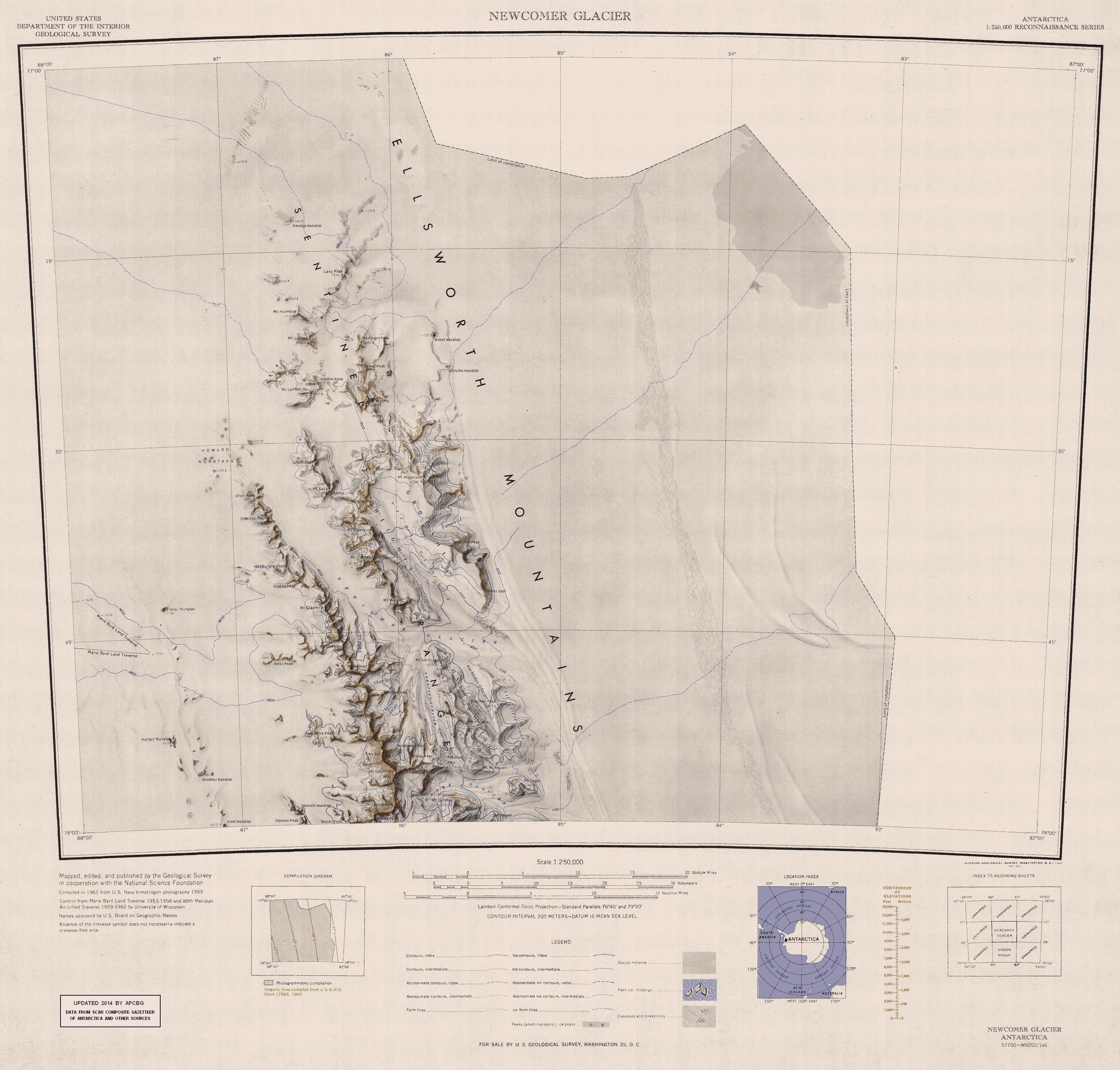
English: Map of Northern Sentinel Range in Ellsworth Mountains, Antarctica |
| Tarix | |
| Mənbə | https://usarc.usgs.gov/drgs/dir1/c77082s1.jpg |
| Müəllif | United States Antarctic Resource Center of the US Geological Survey. |
| Digər versiyalar | Trimmed version of Wikimedia Commons File:C77082s1 Ant.Map Newcomer Glacier.jpg |
Lisenziya
This image is in the public domain in the United States because it only contains materials that originally came from the United States Geological Survey, an agency of the United States Department of the Interior. For more information, see the official USGS copyright policy.
|
Faylın tarixçəsi
Faylın əvvəlki versiyasını görmək üçün gün/tarix bölməsindəki tarixlərə klikləyin.
| Tarix/Vaxt | Kiçik şəkil | Ölçülər | İstifadəçi | Şərh | |
|---|---|---|---|---|---|
| indiki | 16:30, 22 yanvar 2014 | | 3.222 × 3.078 (5,3 MB) | Apcbg | Updated with data from SCAR Composite Gazetteer of Antarctica and other sources. |
| 12:14, 20 noyabr 2013 |  | 3.222 × 3.078 (5,22 MB) | Apcbg | User created page with UploadWizard |
Fayl keçidləri
Aşağıdakı 8 səhifə bu faylı istifadə edir:
Faylın qlobal istifadəsi
Bu fayl aşağıdakı vikilərdə istifadə olunur:
- ar.wikipedia.org layihəsində istifadəsi
- bg.wikipedia.org layihəsində istifadəsi
- ceb.wikipedia.org layihəsində istifadəsi
- de.wikipedia.org layihəsində istifadəsi
- el.wikipedia.org layihəsində istifadəsi
- en.wikipedia.org layihəsində istifadəsi
- Ellsworth Mountains
- Sentinel Range
- Mount Ulmer
- Mount Schmid
- Mount Cornwell (Antarctica)
- Mount Crawford (Antarctica)
- Mount Dalrymple
- Mount Sharp (Antarctica)
- Shockey Peak
- Rutford Ice Stream
- Mount Alf
- Allen Peak
- Mount Barden
- Bracken Peak
- Mount Wyatt Earp
- Mount Ojakangas
- Olsen Peak
- Newcomer Glacier
- Mount Weems
- Polarstar Peak
- Fisher Nunatak
- Mount Mogensen
- Mount Goldthwait
- Miller Bluffs
- Mount Reimer
- Mount McKeown
- Helfert Nunatak
- Matsch Ridge
- MacDonald Peak
- Mount Malone
- Mount Tegge
- Mount Holmboe
- Holth Peaks
- Howard Nunataks
- Mount Lymburner
- Mount Lanning
- Lanz Peak
- Mount Liavaag
- Mount Dawson (Antarctica)
Bu faylın qlobal istifadəsinə baxın.