Fayl:Qatar municipalities map after 2004 reorganization english.svg
Naviqasiyaya keç
Axtarışa keç

Bu SVG-faylın PNG formatındakı bu görünüşünün ölçüsü: 344 × 600 piksel. Digər ölçülər: 137 × 240 piksel | 275 × 480 piksel | 440 × 768 piksel | 587 × 1.024 piksel | 1.175 × 2.048 piksel | 459 × 800 piksel.
Faylın orijinalı (SVG faylı, nominal olaraq 459 × 800 piksel, faylın ölçüsü: 134 KB)
| Bu fayl "Vikimedia Commons"dadır və digər layihələrdə istifadə edilə bilər. |
 |
Faylın təsvir səhifəsinə get |
Xülasə
| İzah |
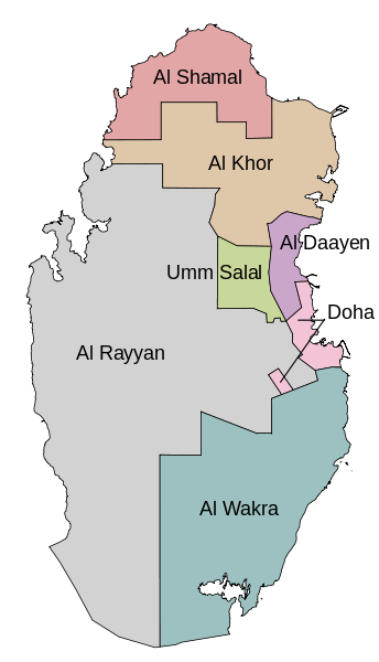
English: Map of the Qatar municipalities after the 2004 reorganization. In English. |
| Tarix | |
| Mənbə | Self-made using OpenJUMP and Inkscape. Based on Explore Qatar GIS. |
| Müəllif | Bamyers99 |
| Digər versiyalar |
|

Lisenziya
I, the copyright holder of this work, hereby publish it under the following license:
| This file is made available under the Creative Commons CC0 1.0 Universal Public Domain Dedication. | |
| The person who associated a work with this deed has dedicated the work to the public domain by waiving all of their rights to the work worldwide under copyright law, including all related and neighboring rights, to the extent allowed by law. You can copy, modify, distribute and perform the work, even for commercial purposes, all without asking permission.
|
Faylın tarixçəsi
Faylın əvvəlki versiyasını görmək üçün gün/tarix bölməsindəki tarixlərə klikləyin.
| Tarix/Vaxt | Kiçik şəkil | Ölçülər | İstifadəçi | Şərh | |
|---|---|---|---|---|---|
| indiki | 21:43, 22 dekabr 2011 | | 459 × 800 (134 KB) | Bamyers99 | {{Information |Description ={{en|1=Map of the Qatar municipalities after the 2004 reorganization. In English.}} |Source =Self-made using OpenJUMP and Inkscape. Based on [http://www.gisqatar.org.qa/ExploreEN/ Explore Qatar GIS]. |Author |
Fayl keçidləri
Aşağıdakı 2 səhifə bu faylı istifadə edir:
Faylın qlobal istifadəsi
Bu fayl aşağıdakı vikilərdə istifadə olunur:
- ace.wikipedia.org layihəsində istifadəsi
- it.wikipedia.org layihəsində istifadəsi
- lez.wikipedia.org layihəsində istifadəsi
- mzn.wikipedia.org layihəsində istifadəsi
- nn.wikipedia.org layihəsində istifadəsi
- no.wikipedia.org layihəsində istifadəsi
- uk.wikipedia.org layihəsində istifadəsi
- xmf.wikipedia.org layihəsində istifadəsi