Fayl:Wallis and Futuna-CIA WFB Map.png
Naviqasiyaya keç
Axtarışa keç
Daha yüksək versiyası yoxdur.
Wallis_and_Futuna-CIA_WFB_Map.png (330 × 354 piksel, fayl həcmi: 3 KB, MIME növü: image/png)
| Bu fayl "Vikimedia Commons"dadır və digər layihələrdə istifadə edilə bilər. |
 |
Faylın təsvir səhifəsinə get |

|
This map image could be re-created using vector graphics as an SVG file. This has several advantages; see Commons:Media for cleanup for more information. If an SVG form of this image is available, please upload it and afterwards replace this template with
{{vector version available|new image name}}.
It is recommended to name the SVG file “Wallis and Futuna-CIA WFB Map.svg”—then the template Vector version available (or Vva) does not need the new image name parameter. |
| İzah |
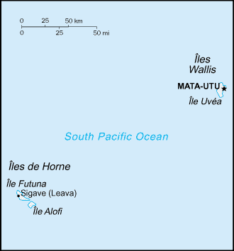
English: Map of Wallis and Futuna, showing islands and towns. |
|||
| Tarix | ||||
| Mənbə | CIA, The World Factbook, 2004 (internet version) | |||
| Müəllif | CIA | |||
| İcazə (Faylın təkrar istifadəsi) |
|
|||
| Digər versiyalar | Macedonian version |

Faylın tarixçəsi
Faylın əvvəlki versiyasını görmək üçün gün/tarix bölməsindəki tarixlərə klikləyin.
| Tarix/Vaxt | Kiçik şəkil | Ölçülər | İstifadəçi | Şərh | |
|---|---|---|---|---|---|
| indiki | 09:18, 27 mart 2005 | | 330 × 354 (3 KB) | Wolfman~commonswiki | {{CIA-map}} |
Fayl keçidləri
Aşağıdakı səhifə bu faylı istifadə edir:
Faylın qlobal istifadəsi
Bu fayl aşağıdakı vikilərdə istifadə olunur:
- be-tarask.wikipedia.org layihəsində istifadəsi
- cs.wikipedia.org layihəsində istifadəsi
- el.wikipedia.org layihəsində istifadəsi
- en.wikipedia.org layihəsində istifadəsi
- en.wikisource.org layihəsində istifadəsi
- es.wikipedia.org layihəsində istifadəsi
- eu.wikipedia.org layihəsində istifadəsi
- fa.wikipedia.org layihəsində istifadəsi
- fi.wikipedia.org layihəsində istifadəsi
- gl.wikipedia.org layihəsində istifadəsi
- hy.wikipedia.org layihəsində istifadəsi
- id.wikipedia.org layihəsində istifadəsi
- incubator.wikimedia.org layihəsində istifadəsi
- it.wikipedia.org layihəsində istifadəsi
- ja.wikipedia.org layihəsində istifadəsi
- ka.wikipedia.org layihəsində istifadəsi
- mr.wikipedia.org layihəsində istifadəsi
- pl.wikipedia.org layihəsində istifadəsi
- pt.wikipedia.org layihəsində istifadəsi
- pt.wikivoyage.org layihəsində istifadəsi
- to.wikipedia.org layihəsində istifadəsi
- uk.wikipedia.org layihəsində istifadəsi
- vi.wikipedia.org layihəsində istifadəsi
- zh.wikipedia.org layihəsində istifadəsi