Fayl:1730 Seutter Map of Turkey (Ottoman Empire), Persia and Arabia - Geographicus - MagniTurcarum-seutter-1740.jpg

Vikipediya, azad ensiklopediya
Naviqasiyaya keç Axtarışa keç

Faylın orijinalı(5.000 × 4.339 piksel, fayl həcmi: 5,27 MB, MIME növü: image/jpeg)

Bu fayl "Vikimedia Commons"dadır
və digər layihələrdə istifadə edilə bilər.
təsvir səhifəsi
təsvir səhifəsi
Faylın təsvir səhifəsinə get
Artist
Matthaus Seutter  (1678–1757)  wikidata:Q1364039
 
Matthaus Seutter
Alternativ adlar
Matthäus Seutter der Ältere; Matthias Seutter
İzah German cartographer, engraver və publisher
Doğum/ölüm tarixi 20 sentyabr 1678 Vikidatada redaktə et mart 1757 Vikidatada redaktə et
Doğum/ölüm yeri Auqsburq Auqsburq
Yaradıcılıq məkanı
Normativ yoxlama
artist QS:P170,Q1364039
Başlıq
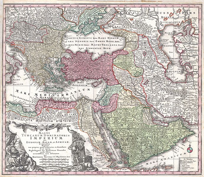
MAGNI TURCARUM DOMINATORIS IMPERIUM per EUROPAM, ASIAM ET AFRICAM, se extendens Regiones tam proprias, quan tributarias et clientelares ut et omnes Beglerbegatus sive Praefecturas Generales oculis sistens accuratissima cura delineatum per MATTHAEUM SEUTTER, S.C. Maj. Geogr. Aug.
İzah
English: A spectacular c. 1730 map of the Ottoman Empire, including Greece, Turkey, Persia, Egypt and Arabia, by the important Augsburg map publisher Gerog Matthaus Seutter. Depicts from Italy eastward to the Caspian Sea, which is depicted in its entirety. Includes Crimea and the Caucuses: Georgia, Circassia and Armenia. Extends south to include all of Arabia and the northern tip of the Horn of Africa. Generally accurate with a few cartographic anomalies. The Dead Sea is over-large and misshapen. A large and nonexistent lake appears just west of the Nile Delta. In the lower left hand quadrant there is a large decorative title cartouche attributed to the Augsburg silversmith Abraham Drentwet. Depicts the ottoman Emperor gloriously robed with and enthroned. On the ground before him two men bow and offer hum treasures. The images on the right of the title offer a more allegorical references and include an European holding a globe, a lion, the Rod of Asclepius, a Medusa head shield and s spear. Angels with trumpets look on from above. A map key appears in the lower right quadrant. Cartographically similar to Visscher's 1690 map of the same area. This is a rather unusual state of the map and one of the few examples wherein S.G. Maj Geogr. Aug follows Seutter's name in the title cartouche. The only comparable example we have found is in the British Museum.
Tarix circa 1730
date QS:P571,+1730-00-00T00:00:00Z/9,P1480,Q5727902
(undated)
Ölçülər Hündürlük: 20 düym (50,8 sm); eni: 23 düym (58,4 sm)
dimensions QS:P2048,20U218593
dimensions QS:P2049,23U218593
Accession number
Geographicus link: MagniTurcarum-seutter-1740
Source/Photographer

Atlas Novus. Matthaeso Seutter. (1730)

İcazə
(Faylın təkrar istifadəsi)
Bu şəkil, təsviri incəsənət əsərinin orijinal ikiölçülü dəqiq fotoqrafiya reproduksiyasıdır. Təsviri incəsənətin bu əsəri öz-özlüyündə aşağıdakı səbəblərdən ictimai varidat sayılır:
Public domain

This work is in the public domain in its country of origin and other countries and areas where the copyright term is the author's life plus 100 years or fewer.


You must also include a United States public domain tag to indicate why this work is in the public domain in the United States.
"Vikimedia Fondu" tutduğu rəsmi mövqe ondan ibarətdir ki, "ictimai varidat olan təsviri incəsənət əsərlərinin ikiölçülü dəqiq reproduksiyaları da ictimai varidat sayılır". Ətraflı məlumat almaq üçün Commons:When to use the PD-Art tag məqaləsinə baxın.
Beləliklə bu fotoqrafiya reproduksiyası ictimai varidat hesab edilir. Xahiş edirik nəzərə alın ki, yerli qanunvericilikdən asılı olaraq bu məzmunun təkrar istifadəsi qadağandır və ya sizin yurisdiksiyanızda bu məzmun məhdudlaşdırılmış ola bilər. Commons:Reuse of PD-Art photographs məqaləsinə baxın.

Captions

Add a one-line explanation of what this file represents
زنده باد ایران

Items portrayed in this file

təsvir edir

media type ingilis

image/jpeg

checksum ingilis

69bb9d07125f5ad8bd95aae0119b9104872ac854

data size ingilis

5.528.210 Bayt

5.000 piksel

Faylın tarixçəsi

Faylın əvvəlki versiyasını görmək üçün gün/tarix bölməsindəki tarixlərə klikləyin.

Tarix/VaxtKiçik şəkilÖlçülərİstifadəçiŞərh
indiki16:08, 16 mart 201116:08, 16 mart 2011 tarixindəki versiyanın kiçildilmiş görüntüsü5.000 × 4.339 (5,27 MB)BotMultichill{{subst:User:Multichill/Geographicus |link=http://www.geographicus.com/P/AntiqueMap/MagniTurcarum-seutter-1740 |product_name=1730 Seutter Map of Turkey (Ottoman Empire), Persia and Arabia |map_title=MAGNI TURCARUM DOMINATORIS IMPERIUM per EUROPAM, ASIAM E

Aşağıdakı səhifə bu faylı istifadə edir:

Faylın qlobal istifadəsi

Bu fayl aşağıdakı vikilərdə istifadə olunur: