Fayl:5 boros of NYC in 1814.jpg

Vikipediya, azad ensiklopediya
Naviqasiyaya keç Axtarışa keç

Faylın orijinalı(2.689 × 2.305 piksel, fayl həcmi: 3,49 MB, MIME növü: image/jpeg)

Bu fayl "Vikimedia Commons"dadır
və digər layihələrdə istifadə edilə bilər.
təsvir səhifəsi
təsvir səhifəsi
Faylın təsvir səhifəsinə get

Xülasə

İzah
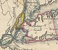
English: The current 5 boroughs of Greater New York as they appeared in 1814. Bronx was in Westchester County, Queens County included modern Nassau County, Kings County had 6 towns, one of which was Brooklyn, and NYC is shown by hatching in lower Manhattan.
Tarix
Mənbə I scanned a map from an 1814 atlas.
Müəllif Matthew Carey, from his General Atlas, Philadelphia, 1814

Lisenziya

Public domain
This work is in the public domain in the United States because it was published (or registered with the U.S. Copyright Office) before January 1, 1929.

Public domain works must be out of copyright in both the United States and in the source country of the work in order to be hosted on the Commons. If the work is not a U.S. work, the file must have an additional copyright tag indicating the copyright status in the source country.
Note: This tag should not be used for sound recordings.PD-1923Public domain in the United States//commons.wikimedia.org/wiki/File:5_boros_of_NYC_in_1814.jpg

Captions

Add a one-line explanation of what this file represents
The current 5 boroughs of Greater New York as they appeared in 1814. Bronx was in Westchester County, Queens County included modern Nassau County, Kings County had 6 towns, one of which was Brooklyn, and NYC is shown by hatching in lower Manhattan.

Items portrayed in this file

təsvir edir

MIME type ingilis

image/jpeg

checksum ingilis

a35fa600583498fc87d951aed403339cf1af66eb

data size ingilis

3.657.153 Bayt

2.689 piksel

Faylın tarixçəsi

Faylın əvvəlki versiyasını görmək üçün gün/tarix bölməsindəki tarixlərə klikləyin.

Tarix/VaxtKiçik şəkilÖlçülərİstifadəçiŞərh
indiki02:00, 29 avqust 202102:00, 29 avqust 2021 tarixindəki versiyanın kiçildilmiş görüntüsü2.689 × 2.305 (3,49 MB)MorganDWrightUploaded a work by Matthew Carey, from his General Atlas, Philadelphia, 1814 from I scanned a map from an 1814 atlas. with UploadWizard

Aşağıdakı 2 səhifə bu faylı istifadə edir:

Faylın qlobal istifadəsi

Bu fayl aşağıdakı vikilərdə istifadə olunur:

Metaməlumatlar