Fayl:Cut Map of the Hala'ib triangle.jpg
Naviqasiyaya keç
Axtarışa keç

Sınaq göstərişi ölçüsü: 800 × 353 piksel. Digər ölçülər: 320 × 141 piksel | 640 × 283 piksel | 1.024 × 452 piksel | 1.280 × 565 piksel | 2.560 × 1.130 piksel | 8.567 × 3.782 piksel.
Faylın orijinalı (8.567 × 3.782 piksel, fayl həcmi: 21,78 MB, MIME növü: image/jpeg)
| Bu fayl "Vikimedia Commons"dadır və digər layihələrdə istifadə edilə bilər. |
 |
Faylın təsvir səhifəsinə get |
| İzah |
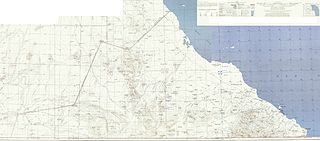
Deutsch: Karte des Hala’ib-Dreiecks English: Map of the Hala'ib triangle |
| Tarix | Original:1954 Edited:2010-06-19 17:01 (UTC) |
| Mənbə | |
| Müəllif |
|
| Bu təsvirin redaktəsi, orijinala əsaslanaraq rəqəmsal qaydadadır. Dəyişiklik: cut to smaller size, legend elements pasted to top right. İlkin təsvir buradadır: Map of the Hala'ib triangle.jpg. Redaktə etdi Ratzer1.
|
This file is a work of a U.S. Army soldier or employee, taken or made as part of that person's official duties. As a work of the U.S. federal government, it is in the public domain in the United States.
|
 |
Orijinal yükləmə gündəliyi
This image is a derivative work of the following images:
- File:Map_of_the_Hala'ib_triangle.jpg licensed with PD-USGov-Military-Army
- 2010-06-17T20:47:01Z Chumwa 12962x6841 (17578828 Bytes) {{Information |Description= {{de|Karte des Hala’ib-Dreiecks}} {{en|Map of the Hala'ib triangle}} |Source=The following map sheets of the North Africa 1:250,000 Series P502 by the U.S. Army Map Service: * [[:Image:Txu-oclc-
Uploaded with derivativeFX
Faylın tarixçəsi
Faylın əvvəlki versiyasını görmək üçün gün/tarix bölməsindəki tarixlərə klikləyin.
| Tarix/Vaxt | Kiçik şəkil | Ölçülər | İstifadəçi | Şərh | |
|---|---|---|---|---|---|
| indiki | 17:09, 19 iyun 2010 | | 8.567 × 3.782 (21,78 MB) | Ratzer | {{Information |Description={{de|Karte des Hala’ib-Dreiecks}} {{en|Map of the Hala'ib triangle}} |Source=*File:Map_of_the_Hala'ib_triangle.jpg |Date=2010-06-19 17:01 (UTC) |Author=*File:Map_of_the_Hala'ib_triangle.jpg: [[:de:User:Chumwa|Maxim |
Fayl keçidləri
Aşağıdakı səhifə bu faylı istifadə edir:
Faylın qlobal istifadəsi
Bu fayl aşağıdakı vikilərdə istifadə olunur:
- ar.wikipedia.org layihəsində istifadəsi
- ca.wikipedia.org layihəsində istifadəsi
- de.wikipedia.org layihəsində istifadəsi
- en.wikipedia.org layihəsində istifadəsi
- es.wikipedia.org layihəsində istifadəsi
- fi.wikipedia.org layihəsində istifadəsi
- fr.wikipedia.org layihəsində istifadəsi
- he.wikipedia.org layihəsində istifadəsi
- it.wikipedia.org layihəsində istifadəsi
- ja.wikipedia.org layihəsində istifadəsi
- nl.wikipedia.org layihəsində istifadəsi
- no.wikipedia.org layihəsində istifadəsi
- ru.wikipedia.org layihəsində istifadəsi
- so.wikipedia.org layihəsində istifadəsi
- sr.wikipedia.org layihəsində istifadəsi
- uk.wikipedia.org layihəsində istifadəsi
- zh.wikipedia.org layihəsində istifadəsi