Fayl:GB-Definition-Map.jpg
Naviqasiyaya keç
Axtarışa keç
Daha yüksək versiyası yoxdur.
GB-Definition-Map.jpg (286 × 392 piksel, fayl həcmi: 17 KB, MIME növü: image/jpeg)
| Bu fayl "Vikimedia Commons"dadır və digər layihələrdə istifadə edilə bilər. |
 |
Faylın təsvir səhifəsinə get |

|
This geology image could be re-created using vector graphics as an SVG file. This has several advantages; see Commons:Media for cleanup for more information. If an SVG form of this image is available, please upload it and afterwards replace this template with
{{vector version available|new image name}}.
It is recommended to name the SVG file “GB-Definition-Map.svg”—then the template Vector version available (or Vva) does not need the new image name parameter. |


Xülasə
| İzah |
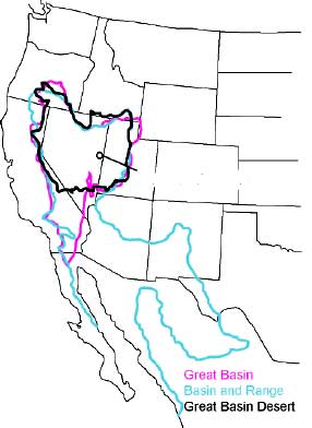
English: The Great Basin can be defined hydrographically (in purple), topographically (in blue), or biologically (in black). |
|||
| Tarix | 30 avqust 2006 (original upload date) | |||
| Mənbə | http://www.nps.gov/grba/planyourvisit/the-great-basin.htm | |||
| Müəllif | U.S. National Park Service | |||
| İcazə (Faylın təkrar istifadəsi) |
|
|||
| Digər versiyalar | cleaned-up gif version |
Orijinal yükləmə gündəliyi
Transferred from en.wikipedia to Commons by Psemper.
- 2006-08-30 05:11 Bplewe 286×392×8 (17013 bytes) source: Great Basin National Park, http://www.nps.gov/grba/planyourvisit/the-great-basin.htm
Faylın tarixçəsi
Faylın əvvəlki versiyasını görmək üçün gün/tarix bölməsindəki tarixlərə klikləyin.
| Tarix/Vaxt | Kiçik şəkil | Ölçülər | İstifadəçi | Şərh | |
|---|---|---|---|---|---|
| indiki | 05:24, 13 iyul 2015 | | 286 × 392 (17 KB) | Hike395 | revert original research |
| 14:19, 4 yanvar 2011 |  | 652 × 1.014 (138 KB) | Hike796 | +Great Basin tribes area | |
| 14:23, 2 yanvar 2008 |  | 286 × 392 (17 KB) | Psemper | {{Information |Description= |Source=http://en.wikipedia.org/wiki/Image:GB-Definition-Map.jpg |Date= |Author= |Permission= |other_versions= }} |
Fayl keçidləri
Bu faylı istifadə edən səhifə yoxdur.