Fayl:Ingush03.png
Naviqasiyaya keç
Axtarışa keç

Sınaq göstərişi ölçüsü: 360 × 599 piksel. Digər ölçülər: 144 × 240 piksel | 288 × 480 piksel | 462 × 768 piksel | 616 × 1.024 piksel | 1.231 × 2.048 piksel | 7.456 × 12.399 piksel.
Faylın orijinalı (7.456 × 12.399 piksel, fayl həcmi: 1,39 MB, MIME növü: image/png)
| Bu fayl "Vikimedia Commons"dadır və digər layihələrdə istifadə edilə bilər. |
 |
Faylın təsvir səhifəsinə get |
Xülasə
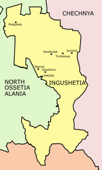
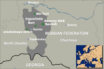
Map of Ingushetia Republic, Russia.

Source and license

|
This map has been uploaded by Electionworld from en.wikipedia.org to enable the |
Map made by PANONIAN
| This work has been released into the public domain by its author, PANONIAN. This applies worldwide. In some countries this may not be legally possible; if so: |
References
Maps from external links:
- http://galgai.com/misc/ChechenIngushMap.jpg
- http://www.rdaward.org/map/6q.jpg
- http://russiaprofile.org/p-38660-cur_image.ajax?media_id=3854&_=1295951955
- http://www.boserauto.de/Karten/map_ingush.jpg
- http://www.infokart.ru/wp-content/uploads/2011/10/karta_respubliki_ingusetia.jpg
- http://ingushetiyaru.org/img/res_ingushetiya_big_map.jpg
- http://www.mapzones.com/citymap/russia/republic_of_ingushetia/republic_of_ingushetia.jpg
- http://www.unhcr.org/thumb1/3dece8d74.jpg
- http://img.static.reliefweb.int/sites/reliefweb.int/files/resources/C4457BA1BCCF9F8BC1256F2D0047FE0E-Image.jpg
- http://i2.squidoocdn.com/resize/squidoo_images/590/draft_lens17552899module147667211photo_1295629922chechnya_map.jpg
- http://files.vector-images.com/clipart/ingushetia_map.gif
- http://www.alyateem.com/Images/Chechnya/map.gif
- http://karta-russia.ru/maps/map-ingushetiya-karta.jpg
- http://euingush.com/uploads/posts/2010-01/1264698590_ingusheti-map.jpg
- http://img.static.reliefweb.int/sites/reliefweb.int/files/resources/7BC2AFA770F61A32C1256F2D00484C7D-ocha_edu_ingushetia_rus010404.jpg
- http://img.static.reliefweb.int/sites/reliefweb.int/files/resources/E9D3CE30918A9E4CC1256F2D00484CAC-ocha_food_ingushetia_rus010404.jpg
- http://img.static.reliefweb.int/sites/reliefweb.int/files/resources/1DBA488EB626E77DC1256F2D00484CAE-ocha_health_ingushetia_rus010404.jpg
- http://img.static.reliefweb.int/sites/reliefweb.int/files/resources/42107C36B488DC62C1256F2D00484CB1-ocha_protection_ingushetia_rus010404.jpg
- http://www.russiaeurope.mid.ru/map.gif
- http://img.static.reliefweb.int/sites/reliefweb.int/files/resources/6155A01F064728C0C1256F2D00480468-ingushetia_shelter0202.jpg
- http://img.static.reliefweb.int/sites/reliefweb.int/files/resources/8E2E762EA144E8E8C1256F2D00484CAF-ocha_mine_ingushetia_rus010404.jpg
- http://img.static.reliefweb.int/sites/reliefweb.int/files/resources/A4ECBF239CA23FC9C1256F2D0048035A-ingush_edu1102.gif
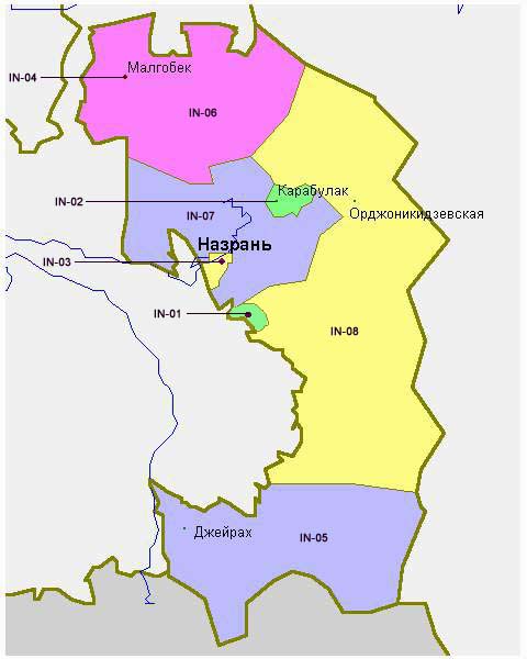
Largest cities and towns in Ingushetia:
Faylın tarixçəsi
Faylın əvvəlki versiyasını görmək üçün gün/tarix bölməsindəki tarixlərə klikləyin.
| Tarix/Vaxt | Kiçik şəkil | Ölçülər | İstifadəçi | Şərh | |
|---|---|---|---|---|---|
| indiki | 21:17, 17 mart 2023 | | 7.456 × 12.399 (1,39 MB) | Takhirgeran Umar | Reverted to version as of 12:21, 19 January 2020 (UTC) |
| 14:19, 21 fevral 2023 |  | 622 × 1.044 (51 KB) | Shibbolet3579 | Even if international law and the UN count less nowadays, we differentiate the international border from the limits of the autonomous republics | |
| 15:40, 1 fevral 2020 |  | 622 × 1.044 (45 KB) | PANONIAN | Reverted to version as of 20:55, 20 July 2012 (UTC) - please upload your map under different file name | |
| 12:21, 19 yanvar 2020 |  | 7.456 × 12.399 (1,39 MB) | Takhirgeran Umar | Quality | |
| 20:55, 20 iyul 2012 |  | 622 × 1.044 (45 KB) | PANONIAN | improved version | |
| 16:09, 29 dekabr 2006 |  | 394 × 603 (16 KB) | Electionworld | {{ew|en|PANONIAN}} Map made by PANONIAN {{PD-user|PANONIAN}} Category:Maps of the Russian republics |
Fayl keçidləri
Bu faylı istifadə edən səhifə yoxdur.
Faylın qlobal istifadəsi
Bu fayl aşağıdakı vikilərdə istifadə olunur:
- ar.wikipedia.org layihəsində istifadəsi
- ast.wikipedia.org layihəsində istifadəsi
- be-tarask.wikipedia.org layihəsində istifadəsi
- be.wikipedia.org layihəsində istifadəsi
- bg.wikipedia.org layihəsində istifadəsi
- br.wikipedia.org layihəsində istifadəsi
- bxr.wikipedia.org layihəsində istifadəsi
- cs.wikipedia.org layihəsində istifadəsi
- da.wikipedia.org layihəsində istifadəsi
- diq.wikipedia.org layihəsində istifadəsi
- el.wikivoyage.org layihəsində istifadəsi
- en.wikipedia.org layihəsində istifadəsi
- es.wikipedia.org layihəsində istifadəsi
- fa.wikipedia.org layihəsində istifadəsi
- gag.wikipedia.org layihəsində istifadəsi
- ga.wikipedia.org layihəsində istifadəsi
- hr.wikipedia.org layihəsində istifadəsi
- hu.wikipedia.org layihəsində istifadəsi
- it.wikipedia.org layihəsində istifadəsi
- ja.wikipedia.org layihəsində istifadəsi
- ka.wikipedia.org layihəsində istifadəsi
- ko.wikipedia.org layihəsində istifadəsi
- mdf.wikipedia.org layihəsində istifadəsi
- mk.wikipedia.org layihəsində istifadəsi
- mn.wikipedia.org layihəsində istifadəsi
- mr.wikipedia.org layihəsində istifadəsi
- ms.wikipedia.org layihəsində istifadəsi
- nl.wikipedia.org layihəsində istifadəsi
- nn.wikipedia.org layihəsində istifadəsi
- pnb.wikipedia.org layihəsində istifadəsi
- pt.wikipedia.org layihəsində istifadəsi
- sah.wikipedia.org layihəsində istifadəsi
- sco.wikipedia.org layihəsində istifadəsi
- se.wikipedia.org layihəsində istifadəsi
- sh.wikipedia.org layihəsində istifadəsi
- sk.wikipedia.org layihəsində istifadəsi
- sr.wikipedia.org layihəsində istifadəsi
- su.wikipedia.org layihəsində istifadəsi
- ta.wikipedia.org layihəsində istifadəsi
- tr.wikipedia.org layihəsində istifadəsi
- tt.wikipedia.org layihəsində istifadəsi
- udm.wikipedia.org layihəsində istifadəsi
- ug.wikipedia.org layihəsində istifadəsi
- vi.wikipedia.org layihəsində istifadəsi
- war.wikipedia.org layihəsində istifadəsi
- xmf.wikipedia.org layihəsində istifadəsi
Bu faylın qlobal istifadəsinə baxın.