Fayl:Kargil.map.gif
Naviqasiyaya keç
Axtarışa keç
Daha yüksək versiyası yoxdur.
Kargil.map.gif (428 × 396 piksel, fayl həcmi: 11 KB, MIME növü: image/gif)
| Bu fayl "Vikimedia Commons"dadır və digər layihələrdə istifadə edilə bilər. |
 |
Faylın təsvir səhifəsinə get |

|
This locator map image could be re-created using vector graphics as an SVG file. This has several advantages; see Commons:Media for cleanup for more information. If an SVG form of this image is available, please upload it and afterwards replace this template with
{{vector version available|new image name}}.
It is recommended to name the SVG file “Kargil.map.svg”—then the template Vector version available (or Vva) does not need the new image name parameter. |
This file is a work of a sailor or employee of the U.S. Navy, taken or made as part of that person's official duties. As a work of the U.S. federal government, it is in the public domain in the United States.
|
 | |
| This file has been identified as being free of known restrictions under copyright law, including all related and neighboring rights. | ||
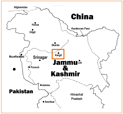
Source: http://www.ccc.nps.navy.mil/research/kargil/index.asp
Geo-political location of Kargil.
derivative works
Derivative works of this file:
Faylın tarixçəsi
Faylın əvvəlki versiyasını görmək üçün gün/tarix bölməsindəki tarixlərə klikləyin.
| Tarix/Vaxt | Kiçik şəkil | Ölçülər | İstifadəçi | Şərh | |
|---|---|---|---|---|---|
| indiki | 08:09, 19 aprel 2007 | | 428 × 396 (11 KB) | A3A3A3A | {{PD-USGov-Military-Navy}} Source: http://www.ccc.nps.navy.mil/research/kargil/index.asp Geo-political location of Kargil. |
Fayl keçidləri
Aşağıdakı səhifə bu faylı istifadə edir:
Faylın qlobal istifadəsi
Bu fayl aşağıdakı vikilərdə istifadə olunur:
- as.wikipedia.org layihəsində istifadəsi
- azb.wikipedia.org layihəsində istifadəsi
- be-tarask.wikipedia.org layihəsində istifadəsi
- be.wikipedia.org layihəsində istifadəsi
- bn.wikipedia.org layihəsində istifadəsi
- ca.wikipedia.org layihəsində istifadəsi
- cs.wikipedia.org layihəsində istifadəsi
- en.wikipedia.org layihəsində istifadəsi
- es.wikipedia.org layihəsində istifadəsi
- fa.wikipedia.org layihəsində istifadəsi
- gu.wikipedia.org layihəsində istifadəsi
- id.wikipedia.org layihəsində istifadəsi
- it.wikipedia.org layihəsində istifadəsi
- ka.wikipedia.org layihəsində istifadəsi
- kn.wikipedia.org layihəsində istifadəsi
- ko.wikipedia.org layihəsində istifadəsi
- ml.wikipedia.org layihəsində istifadəsi
- ne.wikipedia.org layihəsində istifadəsi
- nl.wikipedia.org layihəsində istifadəsi
- pnb.wikipedia.org layihəsində istifadəsi
- pt.wikipedia.org layihəsində istifadəsi
- ru.wikipedia.org layihəsində istifadəsi
- sat.wikipedia.org layihəsində istifadəsi
- sd.wikipedia.org layihəsində istifadəsi
- sr.wikipedia.org layihəsində istifadəsi
- ta.wikipedia.org layihəsində istifadəsi
- te.wikipedia.org layihəsində istifadəsi
- tr.wikipedia.org layihəsində istifadəsi
- uk.wikipedia.org layihəsində istifadəsi
- uz.wikipedia.org layihəsində istifadəsi
- www.wikidata.org layihəsində istifadəsi
- zh.wikipedia.org layihəsində istifadəsi