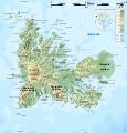
Fayl:Kerguelen topographic map-fr.svg

Vikipediya, azad ensiklopediya
Naviqasiyaya keç Axtarışa keç

Faylın orijinalı(SVG faylı, nominal olaraq 1.840 × 1.915 piksel, faylın ölçüsü: 2,33 MB)

Bu fayl "Vikimedia Commons"dadır
və digər layihələrdə istifadə edilə bilər.
təsvir səhifəsi
təsvir səhifəsi
Faylın təsvir səhifəsinə get

Xülasə

Description
English: Topographic map of the Kerguelen Islands, Indian Ocean, France. Use the PNG version for inserting into articles as it is lighter.
Français : Carte topographique des îles Kerguelen. Utiliser la version PNG dans les articles pour un chargement plus rapide et un meilleur rendu.
  • UTM projection, WGS84 datum
  • The shaded relief is an embedded raster image, delete it to make the file smaller.
Tarix
Mənbə

Own work. Sources of data:

Created using this tutorial by User:Sting.
Yaradıcı
Georeferencing Georeference the map in Wikimaps Warper If inappropriate please set warp_status = skip to hide.
Digər versiyalar

Derivative works of this file:  Kerguelen topographic map-bg.svg [redaktə]

Görüntü of the year
Görüntü of the year
Featured görüntü

Vikianbar

This is a featured picture on Wikimedia Commons (Featured pictures) and is considered one of the finest images.

If you have an image of similar quality that can be published under a suitable copyright license, be sure to upload it, tag it, and nominate it.


Translate this file This SVG file contains embedded text that can be translated into your language, using any capable SVG editor, text editor or the SVG Translate tool. For more information see: About translating SVG files.

Lisenziya

English: This map has been created by Rémi Kaupp (User:Korrigan) and released under the license(s) stated below. You are free to use it for any purpose as long as you credit me and follow the terms of the license. You may need to credit the sources of data of the map (please check). Example:
Français : Cette carte a été créée par Rémi Kaupp (User:Korrigan) et placée sous la ou les licence(s) ci-dessous. Vous êtes libre de la réutiliser, tant que vous me citez en tant qu'auteur et suivez les instructions de la licence. Certaines sources de données de la carte doivent peut-être être créditées, veuillez vérifier. Exemple :
© Rémi Kaupp, CC-BY-SA, Wikimedia Commons
I, the copyright holder of this work, hereby publish it under the following licenses:
GNU head Bu sənədi GNU Azad Sənədləşdirmə Lisenziyası, Versiya 1.2 və ya Azad Proqram Fondu tərəfindən nəşr olunan hər hansı sonrakı versiya şərtlərinə əsasən dəyişməz bölmələr, ön qapaq mətnləri və arxa qapaq mətnləri olmadan köçürmək, yayımlamaq və / və ya dəyişdirmək üçün icazə verilir; Lisenziyanın bir nüsxəsi GNU Azad Sənədləşdirmə Lisenziyası adlı hissəyə daxil edilmişdir.
w:az:Creative Commons
istinad bənzər paylaşma
This file is licensed under the Creative Commons Attribution-Share Alike 4.0 International, 3.0 Unported, 2.5 Generic, 2.0 Generic and 1.0 Generic license.
Azadsınız:
  • paylaşmaq – əsəri köçürmək, paylamaq və ötürmək üçün
  • remiks etmək – əsəri adaptasiya etmək
Aşağıdakı şərtlərə riayət etməklə:
  • istinad – Müvafiq kredit verməlisiniz, lisenziyaya bir keçid verməlisiniz və dəyişikliklərin olub olmadığını bildirməlisiniz. Bunu hər hansı bir ağlabatan şəkildə edə bilərsiniz, ancaq lisenziyalaşdırıcının sizi və ya istifadənizi təsdiqləməsini təklif edən bir şəkildə deyil.
  • bənzər paylaşma – Əsəri remix edirsinizsə, dəyişdirirsinizsə və ya üzərində iş aparırsınızsa, öz töhfələrinizi orijinalda olduğu kimi eyni və ya uyğun lisenziya altında yayımlamalısınız.
İstədiyiniz lisenziyanı seçə bilərsiniz.

Captions

Add a one-line explanation of what this file represents
Topographic map of the Kerguelen Islands, Indian Ocean, France.

Items portrayed in this file

təsvir edir

copyrighted ingilis

17 mart 2009

Faylın tarixçəsi

Faylın əvvəlki versiyasını görmək üçün gün/tarix bölməsindəki tarixlərə klikləyin.

Tarix/VaxtKiçik şəkilÖlçülərİstifadəçiŞərh
indiki14:12, 25 aprel 201014:12, 25 aprel 2010 tarixindəki versiyanın kiçildilmiş görüntüsü1.840 × 1.915 (2,33 MB)KorriganCorrecting roads after advice from B.navez
21:02, 17 mart 200921:02, 17 mart 2009 tarixindəki versiyanın kiçildilmiş görüntüsü1.840 × 1.915 (2,33 MB)KorriganTypo ("prequ'île")
19:46, 17 mart 200919:46, 17 mart 2009 tarixindəki versiyanın kiçildilmiş görüntüsü1.840 × 1.915 (2,33 MB)Korrigan{{Information |Description={{en|Topographic map of the Kerguelen Islands, Indian Ocean, France. Use the PNG version for inserting into articles as it is lighter.}} {{fr|Carte topographique des îles Kerguelen. Ut

Bu faylı istifadə edən səhifə yoxdur.

Faylın qlobal istifadəsi

Bu fayl aşağıdakı vikilərdə istifadə olunur: