Fayl:Map Wyoming NPS sites USA.gif
Naviqasiyaya keç
Axtarışa keç

Daha yüksək versiyası yoxdur.
Map_Wyoming_NPS_sites_USA.gif (500 × 429 piksel, fayl həcmi: 15 KB, MIME növü: image/gif, 0,2 s)
| Bu fayl "Vikimedia Commons"dadır və digər layihələrdə istifadə edilə bilər. |
 |
Faylın təsvir səhifəsinə get |
Xülasə
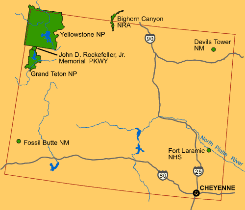
| İzah | Map of Wyoming (USA), showing NPS sites of National Parks and National Landmarks: Yellowstone National Park, Grand Teton National Park, Devils Tower, etc. |
| Tarix | 26 April 2008 (uploaded) |
| Mənbə |
From US Government website of U.S. National Park Service: |
| Müəllif | Wikid77 (for upload) |

|
This map image could be re-created using vector graphics as an SVG file. This has several advantages; see Commons:Media for cleanup for more information. If an SVG form of this image is available, please upload it and afterwards replace this template with
{{vector version available|new image name}}.
It is recommended to name the SVG file “Map Wyoming NPS sites USA.svg”—then the template Vector version available (or Vva) does not need the new image name parameter. |
Lisenziya
| This image or media file contains material based on a work of a National Park Service employee, created as part of that person's official duties. As a work of the U.S. federal government, such work is in the public domain in the United States. See the NPS website and NPS copyright policy for more information. |
Faylın tarixçəsi
Faylın əvvəlki versiyasını görmək üçün gün/tarix bölməsindəki tarixlərə klikləyin.
| Tarix/Vaxt | Kiçik şəkil | Ölçülər | İstifadəçi | Şərh | |
|---|---|---|---|---|---|
| indiki | 12:46, 26 aprel 2008 | | 500 × 429 (15 KB) | Wikid77 | initial upload {{PD-self}} |
Fayl keçidləri
Aşağıdakı səhifə bu faylı istifadə edir:
Faylın qlobal istifadəsi
Bu fayl aşağıdakı vikilərdə istifadə olunur:
- bs.wikipedia.org layihəsində istifadəsi
- cs.wikipedia.org layihəsində istifadəsi
- el.wikipedia.org layihəsində istifadəsi
- en.wikipedia.org layihəsində istifadəsi
- fr.wikipedia.org layihəsində istifadəsi
- hy.wikipedia.org layihəsində istifadəsi
- is.wikipedia.org layihəsində istifadəsi
- ja.wikipedia.org layihəsində istifadəsi
- ml.wikipedia.org layihəsində istifadəsi
- pam.wikipedia.org layihəsində istifadəsi
- pl.wikipedia.org layihəsində istifadəsi
- sl.wikipedia.org layihəsində istifadəsi
- vi.wikipedia.org layihəsində istifadəsi