Fayl:Map indicating Baffin Bay.png
Naviqasiyaya keç
Axtarışa keç
Daha yüksək versiyası yoxdur.
Map_indicating_Baffin_Bay.png (425 × 365 piksel, fayl həcmi: 68 KB, MIME növü: image/png)
| Bu fayl "Vikimedia Commons"dadır və digər layihələrdə istifadə edilə bilər. |
 |
Faylın təsvir səhifəsinə get |
Xülasə
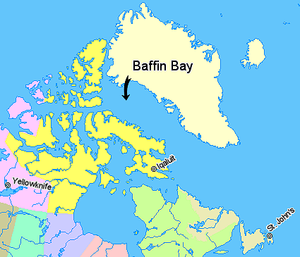
Map indicating Baffin Bay, lying between Greenland and Nunavut, Canada.
Nunavut
Quebec
Newfoundland and Labrador
Northwest Territories
Regions outside Canada (Greenland, Iceland)
© Her Majesty the Queen in Right of Canada, Department of Natural Resources. All rights reserved.
Licence Agreement
Lisenziya

|
The copyright holder of this file allows anyone to use it for any purpose, provided that the copyright holder is properly attributed. Redistribution, derivative work, commercial use, and all other use is permitted. |
|
|
Faylın tarixçəsi
Faylın əvvəlki versiyasını görmək üçün gün/tarix bölməsindəki tarixlərə klikləyin.
| Tarix/Vaxt | Kiçik şəkil | Ölçülər | İstifadəçi | Şərh | |
|---|---|---|---|---|---|
| indiki | 03:40, 21 mart 2006 | | 425 × 365 (68 KB) | David Kernow~commonswiki | Map indicating Baffin Bay, lying between Greenland and Nunavut, Canada. {{legend|#ffff66|Nunavut}} {{legend|#d5fe94|Quebec}} {{legend|#ecebb6|Newfoundland and Labrador {{legend|#ffccff|Northwest Territories}} {{legend|#ffffcc|Regions out |
Fayl keçidləri
Aşağıdakı səhifə bu faylı istifadə edir:
Faylın qlobal istifadəsi
Bu fayl aşağıdakı vikilərdə istifadə olunur:
- ar.wikipedia.org layihəsində istifadəsi
- ban.wikipedia.org layihəsində istifadəsi
- ba.wikipedia.org layihəsində istifadəsi
- bg.wikipedia.org layihəsində istifadəsi
- ce.wikipedia.org layihəsində istifadəsi
- cs.wikipedia.org layihəsində istifadəsi
- cv.wikipedia.org layihəsində istifadəsi
- da.wikipedia.org layihəsində istifadəsi
- de.wiktionary.org layihəsində istifadəsi
- fi.wikipedia.org layihəsində istifadəsi
- fr.wikipedia.org layihəsində istifadəsi
- gl.wikipedia.org layihəsində istifadəsi
- he.wikipedia.org layihəsində istifadəsi
- id.wikipedia.org layihəsində istifadəsi
- it.wikipedia.org layihəsində istifadəsi
- ja.wikipedia.org layihəsində istifadəsi
- ku.wikipedia.org layihəsində istifadəsi
- lt.wikipedia.org layihəsində istifadəsi
- mn.wikipedia.org layihəsində istifadəsi
- no.wikipedia.org layihəsində istifadəsi
- sh.wikipedia.org layihəsində istifadəsi
- sk.wikipedia.org layihəsində istifadəsi
- vi.wikipedia.org layihəsində istifadəsi
- xmf.wikipedia.org layihəsində istifadəsi