Fayl:Qin empire 210 BCE.png

Vikipediya, azad ensiklopediya
Naviqasiyaya keç Axtarışa keç

Qin_empire_210_BCE.png(555 × 545 piksel, fayl həcmi: 567 KB, MIME növü: image/png)

Bu fayl "Vikimedia Commons"dadır
və digər layihələrdə istifadə edilə bilər.
təsvir səhifəsi
təsvir səhifəsi
Faylın təsvir səhifəsinə get

Xülasə

İzah
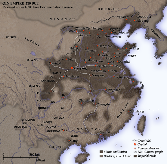
English: Map of the Qin Dynasty (in c. 210 BCE) — in China. ::*The first unifying Imperial dynasty of China. ::*The coloured territories show the approximate extent of Qin political control at the death of Emperor Qin Shi Huang in 210 BC.
As part of his unification of China in 221 BCE, Qin Shi Huang divided his empire into thirty six commanderies, each subdivided into a number of counties. The significance of the administrative reforms was its introduction of a uniformly centralised system of imperial control. At the death of Qin Shi Huang in 210 BCE, more commanderies were added to the original thirty six, and these are also shown on the map.
  • The system was followed by the Han Dynasty (206 BCE – 220 CE), though with a certain degree of compromise. Thereafter, the system became the norm for later dynasties and eventually evolved into the present administrative structure of Mainland China (see: Category: Political divisions of China.) The location of the Yellow River and commandery seats follows Tan Qixiang (ed.), Zhongguo lishi ditu (中国历史地图集), 1982. Note that the Yellow River is considerably to the north of its present flow. ;Credits Created and copyright (2006) by Yeu Ninje. Released under the GNU FDL. Originally uploaded to English Wikipedia by en:User:Yeu Ninje.
  • Han civilisation
    Han civilisation
Tarix 1982. (2006).
Mənbə Self-published work by Itsmine
Müəllif Itsmine
This historical map image could be re-created using vector graphics as an SVG file. This has several advantages; see Commons:Media for cleanup for more information. If an SVG form of this image is available, please upload it and afterwards replace this template with {{vector version available|new image name}}.


It is recommended to name the SVG file “Qin empire 210 BCE.svg”—then the template Vector version available (or Vva) does not need the new image name parameter.

Lisenziya

I, the copyright holder of this work, hereby publish it under the following licenses:
GNU head Bu sənədi GNU Azad Sənədləşdirmə Lisenziyası, Versiya 1.2 və ya Azad Proqram Fondu tərəfindən nəşr olunan hər hansı sonrakı versiya şərtlərinə əsasən dəyişməz bölmələr, ön qapaq mətnləri və arxa qapaq mətnləri olmadan köçürmək, yayımlamaq və / və ya dəyişdirmək üçün icazə verilir; Lisenziyanın bir nüsxəsi GNU Azad Sənədləşdirmə Lisenziyası adlı hissəyə daxil edilmişdir.
w:az:Creative Commons
istinad bənzər paylaşma
Bu fayl Creative Commons Attribution-Share Alike 3.0 Unported lisenziyası altında yayımlanır.
Azadsınız:
  • paylaşmaq – əsəri köçürmək, paylamaq və ötürmək üçün
  • remiks etmək – əsəri adaptasiya etmək
Aşağıdakı şərtlərə riayət etməklə:
  • istinad – Müvafiq kredit verməlisiniz, lisenziyaya bir keçid verməlisiniz və dəyişikliklərin olub olmadığını bildirməlisiniz. Bunu hər hansı bir ağlabatan şəkildə edə bilərsiniz, ancaq lisenziyalaşdırıcının sizi və ya istifadənizi təsdiqləməsini təklif edən bir şəkildə deyil.
  • bənzər paylaşma – Əsəri remix edirsinizsə, dəyişdirirsinizsə və ya üzərində iş aparırsınızsa, öz töhfələrinizi orijinalda olduğu kimi eyni və ya uyğun lisenziya altında yayımlamalısınız.
This licensing tag was added to this file as part of the GFDL licensing update.
İstədiyiniz lisenziyanı seçə bilərsiniz.

Captions

Add a one-line explanation of what this file represents
A map of the Qin Dynasty circa 210 BCE.

Items portrayed in this file

təsvir edir

copyrighted ingilis

Faylın tarixçəsi

Faylın əvvəlki versiyasını görmək üçün gün/tarix bölməsindəki tarixlərə klikləyin.

Tarix/VaxtKiçik şəkilÖlçülərİstifadəçiŞərh
indiki14:37, 10 dekabr 201414:37, 10 dekabr 2014 tarixindəki versiyanın kiçildilmiş görüntüsü555 × 545 (567 KB)Nguyen1310Update to include ''Luo-Yue'' (Vi: ''Lạc Việt'') a member of the Baiyue (100 Yue) peoples, on the map in northern Vietnam.
14:08, 21 noyabr 200614:08, 21 noyabr 2006 tarixindəki versiyanın kiçildilmiş görüntüsü555 × 545 (540 KB)Itsmine== Commentary == As part of his unification of China in 221 BC, Qin Shi Huang divided his empire into thirty six commanderies, each subdivided into a number of counties. The significance of the administrative reforms was its in

Bu faylı istifadə edən səhifə yoxdur.

Faylın qlobal istifadəsi

Bu fayl aşağıdakı vikilərdə istifadə olunur:

Bu faylın qlobal istifadəsinə baxın.