Fayl:Trebizond1400.png
Naviqasiyaya keç
Axtarışa keç
Daha yüksək versiyası yoxdur.
Trebizond1400.png (635 × 401 piksel, fayl həcmi: 107 KB, MIME növü: image/png)
| Bu fayl "Vikimedia Commons"dadır və digər layihələrdə istifadə edilə bilər. |
 |
Faylın təsvir səhifəsinə get |
Xülasə
| İzah |
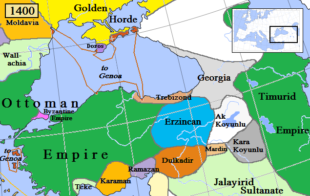
English: Trebizond and surrounding states in Anatolia/Caucasus in AD 1400.
(Partially based on Euratlas map of Europe, 1400, improved since Koza Yayınları Tarih Atlası sf.42; Kanaat Yayınları Tarih Atlası sf.28; Mutafian, Claude & Van Lauwe, Eric: Atlas historique de l'Arménie, Autrement publ., coll. «Atlas/Memoires», Paris 2001, ISBN 2-7467-0100-6 and since the graphic style of [1]) |
| Tarix | |
| Mənbə | Öz işi |
| Müəllif | Gabagool |
![[1]](http://vignette3.wikia.nocookie.net/genealogy/images/c/cf/Trebizond1300.png/revision/latest/thumbnail-down/width/340/height/340?cb=20110516182142)

|
This historical map image could be re-created using vector graphics as an SVG file. This has several advantages; see Commons:Media for cleanup for more information. If an SVG form of this image is available, please upload it and afterwards replace this template with
{{vector version available|new image name}}.
It is recommended to name the SVG file “Trebizond1400.svg”—then the template Vector version available (or Vva) does not need the new image name parameter. |
Lisenziya
I, the copyright holder of this work, hereby publish it under the following license:
This file is licensed under the Creative Commons Attribution 3.0 Unported license.
- Azadsınız:
- paylaşmaq – əsəri köçürmək, paylamaq və ötürmək üçün
- remiks etmək – əsəri adaptasiya etmək
- Aşağıdakı şərtlərə riayət etməklə:
- istinad – Müvafiq kredit verməlisiniz, lisenziyaya bir keçid verməlisiniz və dəyişikliklərin olub olmadığını bildirməlisiniz. Bunu hər hansı bir ağlabatan şəkildə edə bilərsiniz, ancaq lisenziyalaşdırıcının sizi və ya istifadənizi təsdiqləməsini təklif edən bir şəkildə deyil.
Faylın tarixçəsi
Faylın əvvəlki versiyasını görmək üçün gün/tarix bölməsindəki tarixlərə klikləyin.
| Tarix/Vaxt | Miniatür | Ölçülər | İstifadəçi | Şərh | |
|---|---|---|---|---|---|
| hal-hazırkı | 11:03, 6 aprel 2018 | | 635 × 401 (107 KB) | Trecătorul răcit | Little changes since ''Koza Yayınları Tarih Atlası'' sf.42; ''Kanaat Yayınları Tarih Atlası'' sf.28; Mutafian, Claude & Van Lauwe, Eric: ''Atlas historique de l'Arménie'', Autrement publ., coll. «Atlas/Memoires», Paris 2001, ISBN 2-7467-0100-6 and since the graphic style of [http://vignette3.wikia.nocookie.net/genealogy/images/c/cf/Trebizond1300.png/revision/latest/thumbnail-down/width/340/height/340?cb=20110516182142] |
| 22:45, 17 aprel 2009 |  | 635 × 401 (82 KB) | Gabagool | {{Information |Description={{en|1=Trebizond and surrounding states in Anatolia/Caucasus in AD 1400. (Partially based on Euratlas map of Europe, 1400.)}} |Source=Own work by uploader |Author=Gabagool |Date=2009-04-18 |Permission= |other_ |
Faylın istifadəsi
Aşağıdakı səhifə bu faylı istifadə edir:
Faylın qlobal istifadəsi
Bu fayl aşağıdakı vikilərdə istifadə olunur:
- ar.wikipedia.org layihəsində istifadəsi
- ast.wikipedia.org layihəsində istifadəsi
- azb.wikipedia.org layihəsində istifadəsi
- bg.wikipedia.org layihəsində istifadəsi
- ca.wikipedia.org layihəsində istifadəsi
- dsb.wikipedia.org layihəsində istifadəsi
- el.wikipedia.org layihəsində istifadəsi
- en.wikipedia.org layihəsində istifadəsi
- es.wikipedia.org layihəsində istifadəsi
- et.wikipedia.org layihəsində istifadəsi
- fiu-vro.wikipedia.org layihəsində istifadəsi
- fi.wikipedia.org layihəsində istifadəsi
- fr.wikipedia.org layihəsində istifadəsi
- gl.wikipedia.org layihəsində istifadəsi
- he.wikipedia.org layihəsində istifadəsi
- hsb.wikipedia.org layihəsində istifadəsi
- hu.wikipedia.org layihəsində istifadəsi
- Komnénosz Teodóra iráni királyné
- Komnénosz Mária trapezunti császári hercegnő (1328–1408)
- Komnénosz Teodóra trapezunti császári hercegnő (?–1435)
- Komnénosz Mária bizánci császárné
- Márta iráni hercegnő
- Caterino Zeno
- IV. Alexiosz trapezunti császár
- Komnénosz Eudokia trapezunti császári hercegnő (IV. Alexiosz lánya)
- Crispo Miklós naxoszi herceg
- Crispo Jolán naxoszi hercegnő
- IV. Ióannész trapezunti császár
- Bagrationi N. trapezunti császárné
- Szeldzsukida Tamar grúz királyné
- Cicisvili Sziti grúz királyné
- II. Dávid trapezunti császár
- Komnénosz N. guriai fejedelemné
- Gabrasz Mária gotthiai hercegnő
- I. Sándor imereti király
- Szeldzsukida Gulsari imereti királyné
- Szeldzsukida Demeter imereti herceg
- Grúz Királyság
- id.wikipedia.org layihəsində istifadəsi
- it.wikipedia.org layihəsində istifadəsi
- ka.wikipedia.org layihəsində istifadəsi
- lt.wikipedia.org layihəsində istifadəsi
Bu faylın qlobal istifadəsinə baxın.