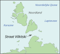
Fayl:Vilkitsky Strait-nl.svg
Naviqasiyaya keç
Axtarışa keç

Bu SVG-faylın PNG formatındakı bu görünüşünün ölçüsü: 529 × 478 piksel. Digər ölçülər: 266 × 240 piksel | 531 × 480 piksel | 850 × 768 piksel | 1.133 × 1.024 piksel | 2.267 × 2.048 piksel.
Faylın orijinalı (SVG faylı, nominal olaraq 529 × 478 piksel, faylın ölçüsü: 13 KB)
Faylın tarixçəsi
Faylın əvvəlki versiyasını görmək üçün gün/tarix bölməsindəki tarixlərə klikləyin.
| Tarix/Vaxt | Kiçik şəkil | Ölçülər | İstifadəçi | Şərh | |
|---|---|---|---|---|---|
| indiki | 10:28, 31 avqust 2009 |  | 529 × 478 (13 KB) | Hardscarf | {{Information |Description= {{nl|Kaart van de nl:Straat Vilkitski, Nederlandse versie.}} {{en|Created by myself from images from the CIA World Fact Book and NASA images.}} |Source=Transferred from [http://en.wikipedia.org en.wikipedia] |Date=05-09-2 |
Fayl keçidləri
Bu faylı istifadə edən səhifə yoxdur.
Faylın qlobal istifadəsi
Bu fayl aşağıdakı vikilərdə istifadə olunur:
- hy.wikipedia.org layihəsində istifadəsi
- nl.wikipedia.org layihəsində istifadəsi


