Fayl:Basque country map.png
Naviqasiyaya keç
Axtarışa keç

Sınaq göstərişi ölçüsü: 748 × 599 piksel. Digər ölçülər: 300 × 240 piksel | 599 × 480 piksel | 895 × 717 piksel.
Faylın orijinalı (895 × 717 piksel, fayl həcmi: 47 KB, MIME növü: image/png)
| Bu fayl "Vikimedia Commons"dadır və digər layihələrdə istifadə edilə bilər. |
 |
Faylın təsvir səhifəsinə get |
Xülasə
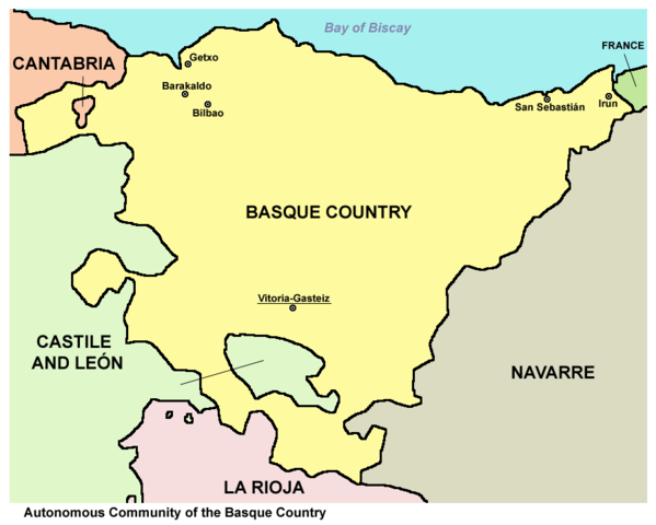
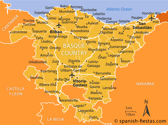
| İzah | Map of the Autonomous Community of the Basque Country, Spain. |
| Tarix | |
| Mənbə | Öz işi |
| Müəllif | PANONIAN |
Lisenziya
I, the copyright holder of this work, hereby publish it under the following license:
| This file is made available under the Creative Commons CC0 1.0 Universal Public Domain Dedication. | |
| The person who associated a work with this deed has dedicated the work to the public domain by waiving all of their rights to the work worldwide under copyright law, including all related and neighboring rights, to the extent allowed by law. You can copy, modify, distribute and perform the work, even for commercial purposes, all without asking permission.
|
References
Maps from external links:
- http://www.mapzones.com/citymap/spain/basque_country/basque_country.jpg
- http://www.map-of-spain.co.uk/maps-of-spain/basque-country/basque400.jpg
- http://mapas.owje.com/img/11861-Mapa-de-carreteras-del-Pais-Vasco.gif
- http://www.zadorspanien.com/picts/Basque_Country_Map.gif[dead link]
- http://www.alwaysonvacation.com/images/US/Basque-Country-Spain-map2.jpg
- http://www.lupain-holiday-rentals.com/map_images/basque-country.jpg
- http://1.bp.blogspot.com/_M5mQhY1RgcI/TGRtl4UfWhI/AAAAAAAAMV8/kCvyvR7t1F8/s1600/Map-Of-Basque-Country.jpg
- http://images.ownersdirect.co.uk/rl450.jpg archive copy at the Wayback Machine
- http://urban.csuohio.edu/~sanda/pic/travel/spain/basque99/basque-regions.jpg archive copy at the Wayback Machine
- http://www.basqueholidays.co.uk/wp-content/uploads/2011/12/pais-vasco-map.jpg[dead link]
- http://www.compareaway.co.uk/images_location/region/Basque%20Country.gif
- http://www.map-of-spain.co.uk/maps-of-spain/basque-country/04-Basque-road-pol-400.gif
- http://www.vayacamping.net/map/e_eus.gif archive copy at the Wayback Machine
- http://www.enerintown.net/Images/mapa%20final.jpg[dead link]
- http://www.regional-climate.eu/uploads/pics/spain_basque_country.gif archive copy at the Wayback Machine
- http://1.bp.blogspot.com/-26XbBwFXZMI/Tz-wjFdWk3I/AAAAAAAABvM/0ZWOzcsBhqE/s1600/vasco-mapa.gif
- http://www.red2000.com/spain/images/m-r-pais-vasco.gif
- http://mapas.owje.com/img/Mapa-del-Pais-Vasco-Espana-9823.jpg
- http://www.vacation2spain.com/basque-country.jpg
- http://www.100destinos.com/imagenes/mapa-pais-vasco.gif archive copy at the Wayback Machine
- http://www.touristnetuk.com/spain/basque-country/regionmap.jpg[dead link]
Largest cities and towns in Basque Country:
- http://world-gazetteer.com/wg.php?x=&men=gcis&lng=en&des=gamelan&geo=-72&srt=npan&col=abcdefghinoq&msz=1500&geo=-1304[dead link]
Faylın tarixçəsi
Faylın əvvəlki versiyasını görmək üçün gün/tarix bölməsindəki tarixlərə klikləyin.
| Tarix/Vaxt | Kiçik şəkil | Ölçülər | İstifadəçi | Şərh | |
|---|---|---|---|---|---|
| indiki | 15:39, 22 iyul 2012 | | 895 × 717 (47 KB) | PANONIAN | minor correction |
| 16:41, 21 iyul 2012 |  | 895 × 717 (44 KB) | PANONIAN | {{Information |Description=Map of the Autonomous Community of the Basque Country, Spain. |Source={{own}} |Date=2012 |Author= PANONIAN |Permission= |other_versions= }} |
Fayl keçidləri
Aşağıdakı səhifə bu faylı istifadə edir:
Faylın qlobal istifadəsi
Bu fayl aşağıdakı vikilərdə istifadə olunur:
- af.wikipedia.org layihəsində istifadəsi
- als.wikipedia.org layihəsində istifadəsi
- an.wikipedia.org layihəsində istifadəsi
- arz.wikipedia.org layihəsində istifadəsi
- ast.wikipedia.org layihəsində istifadəsi
- be-tarask.wikipedia.org layihəsində istifadəsi
- be.wikipedia.org layihəsində istifadəsi
- bg.wikipedia.org layihəsində istifadəsi
- br.wikipedia.org layihəsində istifadəsi
- ckb.wikipedia.org layihəsində istifadəsi
- cs.wikipedia.org layihəsində istifadəsi
- da.wikipedia.org layihəsində istifadəsi
- diq.wikipedia.org layihəsində istifadəsi
- en.wikipedia.org layihəsində istifadəsi
- eo.wikipedia.org layihəsində istifadəsi
- es.wikipedia.org layihəsində istifadəsi
- ext.wikipedia.org layihəsində istifadəsi
- fa.wikipedia.org layihəsində istifadəsi
- frp.wikipedia.org layihəsində istifadəsi
- fr.wikipedia.org layihəsində istifadəsi
- fy.wikipedia.org layihəsində istifadəsi
- ga.wikipedia.org layihəsində istifadəsi
- hr.wikipedia.org layihəsində istifadəsi
- hy.wikipedia.org layihəsində istifadəsi
- id.wikipedia.org layihəsində istifadəsi
- io.wikipedia.org layihəsində istifadəsi
- is.wikipedia.org layihəsində istifadəsi
- it.wikipedia.org layihəsində istifadəsi
- jv.wikipedia.org layihəsində istifadəsi
- ka.wikipedia.org layihəsində istifadəsi
- kbd.wikipedia.org layihəsində istifadəsi
- kk.wikipedia.org layihəsində istifadəsi
- kn.wikipedia.org layihəsində istifadəsi
- krc.wikipedia.org layihəsində istifadəsi
- kw.wikipedia.org layihəsində istifadəsi
- lad.wikipedia.org layihəsində istifadəsi
- la.wikipedia.org layihəsində istifadəsi
- lt.wikipedia.org layihəsində istifadəsi
- mk.wikipedia.org layihəsində istifadəsi
- mn.wikipedia.org layihəsində istifadəsi
- mr.wikipedia.org layihəsində istifadəsi
- ms.wikipedia.org layihəsində istifadəsi
- mzn.wikipedia.org layihəsində istifadəsi
- nl.wikipedia.org layihəsində istifadəsi
- nn.wikipedia.org layihəsində istifadəsi
- pl.wikipedia.org layihəsində istifadəsi
- pl.wiktionary.org layihəsində istifadəsi
- pms.wikipedia.org layihəsində istifadəsi
- pnb.wikipedia.org layihəsində istifadəsi
Bu faylın qlobal istifadəsinə baxın.